METAR & TAF KCVC
Current METAR
Observed 03:35Z
KCVC 270335Z AUTO 00000KT 3/4SM BR SCT120 26/24 A2993 RMK AO2
- Wind
- 000° @ 0 kt
- Visibility
- 0.75 SM
- Temp / Dew
- 26°C / 24°C
- Altimeter
- 29.93 inHg
- Clouds
- SCT
- Density alt
- 2,324 ft
- Ceiling
- Unlimited
- Rules
- LIFR
Airport info & contacts
Manager on record, flight service, ARTCC, attendance schedule and pattern altitude — published by the FAA and refreshed every 28 days.
Location
- From city
- 35 NM ESE
- VFR sectional
- ATLANTA
- ARTCC
- ZTL · ATLANTA
- NOTAM facility
- CVC (NOTAM-D)
Airport manager
- Name
- ADAM WEBB
- Phone
- 770-787-3996
- Address
- 14100 HIGHWAY 142, COVINGTON GA 30014
Flight service · Hours
- FSS MCN
- MACON1-800-WX-BRIEF
- Attendance
- MON-FRI · 0800-1700
- SAT-SUN · 0900-1700
Frequencies
Tap any row to copy the frequency to your clipboard.
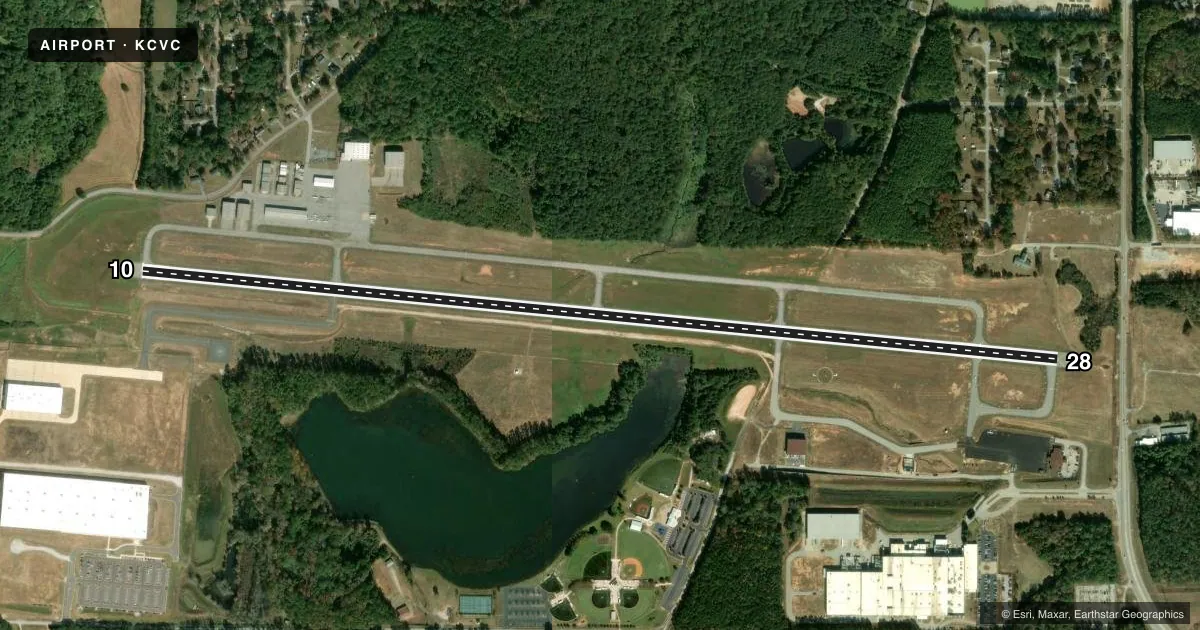
Runways & pattern
Full pagePattern entry · RWY 10
LEFT TRAFFICRunway end performance
| End | TORA | TODA | ASDA | LDA | VGSI | Approach lights | Obstruction |
|---|---|---|---|---|---|---|---|
| 10 | 6,000' | 6,000' | 5,800' | 5,800' | PAPI 2-box left(4°) | — | 40', trees, 707' from thr, 279' R of cntrln, slope 12 |
| 28 | 6,000' | 6,000' | 6,000' | 5,500' | PAPI 2-box left(3°) | MALSR | 24', pole, 406' from thr, 222' R of cntrln, slope 8 |
Declared distances in feet. TORA = takeoff run available, TODA = takeoff distance, ASDA = accelerate-stop, LDA = landing distance.
Airport sketch
Runways drawn to scale from FAA survey coordinates, rendered over satellite imagery. Not for navigation.
Approaches & charts
Services on the field
Fuel grades, oxygen, maintenance, ramp storage and lighting — as declared to the FAA by the airport operator.
Fuel & services
- Fuel
- 100LLA+
- Oxygen (bottled)
- Not available
- Oxygen (bulk)
- Not available
- Airframe repair
- Major
- Power plant repair
- Major
- Other services
- AMB,INSTR
Ramp & ground
- Transient storage
- Tie-down
- Hangar
- Landing fee
- No fee published
- Customs
- Not available
- Lighting schedule
- SEE RMK
- Beacon schedule
- SS-SR
- Beacon
- White / Green (civil land)(WG)
- Wind indicator
- Lighted
- Segmented circle
- Yes
Fuel & FBOs
Cheapest 100LL and Jet A on the field and nearby. Always confirm with the FBO before taxi.
Airport notes
Surface conditions, obstructions, local procedures, lighting outages and other notes published with each FAA cycle.
General notes
- DEER AND MIGRATORY BIRDS ON & INVOF ARPT.
- AVOID OVERFLYING POPULATED AREA SW OF ARPT BLO 1500 FT AGL.
- NO 180 DEGREE TURNS ON ASPH FOR ACFT OVER 12500 LBS GWT.
- FOR CD CTC ATLANTA APCH AT 678-364-6131.
Lighting notes
- ACTVT MALSR RWY 28; PAPI RWY 10 & 28; MIRL RWY 10/28 - CTAF.
Other notes
- EXISTED PRIOR TO 1959.
- MANAGERARPT PHONE 770-787-0098.
VFR map & nearby airports
VFR sectional. Tap any ICAO chip to open that airport.
Key facts · KCVC
Answer card- ICAO
- KCVC
- Name
- COVINGTON MUNI
- Location
- ATLANTA, GEORGIA
- Elevation
- 819.9 ft MSL
- Traffic pattern altitude
- 1,819.9 ft MSL (1,000 AGL)
- Control tower
- Non-towered (use CTAF)
- Total runways
- 1
- Longest runway
- 10/28 · 6,000 ft
- Published ILS approaches
- 0
- Published frequencies
- 4
- Magnetic variation
- 5°
- Current flight rules
- LIFR
- Current wind
- 000° at 0 kt
- Favored runway now
- –
Covington Muni is in Atlanta, Georgia. The field elevation is 819.9 ft MSL. It has one runway. Runway 10/28 is 6,000 ft long and asphalt. There is no control tower, so use CTAF 123.0 for local traffic calls. No ILS approaches are published here. The pattern altitude is not published, so use 1,000 ft AGL for light piston operations unless the current Chart Supplement says otherwise.
The on-field FBO is Covington Municipal Airport. It carries 100LL and Jet A. Call (770) 787-0098 for current services before you go. Published remarks say runway 28 has MALSR lighting. PAPI is available on both runway ends. Medium intensity runway lights are also available on 10 and 28. Atlanta Approach handles clearance delivery at 678-364-6131.
A few local items matter here. Avoid overflying the populated area southwest of the airport below 1,500 ft AGL. Deer and migratory birds are reported on and near the field. Aircraft over 12,500 pounds gross weight should not make 180 degree turns on the asphalt. If you are planning a night arrival or a heavier operation, brief the lighting and traffic flow before you launch. Check the current Chart Supplement for any noise or curfew restrictions before flying into the field.