METAR & TAF KWDR
Current METAR
Observed 11:55Z
KWDR 271155Z 10SM CLR 24/23 A2994 RMK AO2 LTG DSNT W
- Wind
- Calm
- Visibility
- 10 SM
- Temp / Dew
- 24°C / 23°C
- Altimeter
- 29.94 inHg
- Clouds
- CLR
- Density alt
- 2,214 ft
- Ceiling
- Unlimited
- Rules
- VFR
Airport info & contacts
Manager on record, flight service, ARTCC, attendance schedule and pattern altitude — published by the FAA and refreshed every 28 days.
Location
- From city
- 3 NM E
- VFR sectional
- ATLANTA
- ARTCC
- ZTL · ATLANTA
- NOTAM facility
- WDR (NOTAM-D)
Airport manager
- Name
- STONEY BANGERT
- Phone
- 770-307-3013
- Address
- 841 RONALD WOOD RD, WINDER GA 30680
Flight service · Hours
- FSS MCN
- MACON1-800-WX-BRIEF
- Attendance
- M-F · 0900-1800
- SAT · 0900-1700
- SUN · 1100-1700
Frequencies
Tap any row to copy the frequency to your clipboard.
Runways & pattern
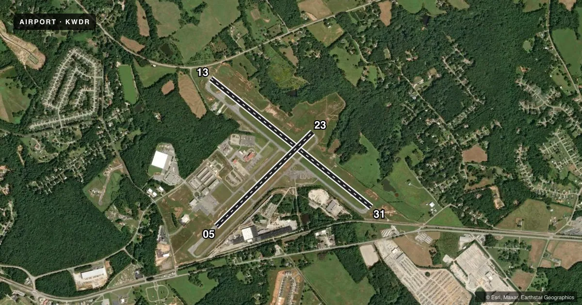
Full pagePattern entry · RWY 13
LEFT TRAFFIC| Runway | Heading (°M) | Length | Surface | Traffic |
|---|---|---|---|---|
| 13/31 | 124° / 304° | 5,505 ft | ASPH | Standard L |
| 05/23 | 41° / 221° | 3,607 ft | ASPH | Standard L |
Runway end performance
| End | TORA | TODA | ASDA | LDA | VGSI | Approach lights | Obstruction |
|---|---|---|---|---|---|---|---|
| 13 | 5,505' | 5,505' | 5,405' | 5,105' | PAPI 4-box left(3°) | — | 27', pole, 687' from thr, 366' R of cntrln, slope 18 |
| 31 | 5,505' | 5,505' | 5,405' | 4,798' | PAPI 4-box left(3°) | MALSR | 15', rr, 201' from thr, 270' R of cntrln, slope 0 |
| 05 | — | — | — | — | PAPI 2-box left(3°) | — | 46', trees, 1067' from thr, 313' R of cntrln, slope 18 |
| 23 | — | — | — | — | PAPI 2-box left(3°) | — | 38', trees, 642' from thr, 313' R of cntrln, slope 11 |
Declared distances in feet. TORA = takeoff run available, TODA = takeoff distance, ASDA = accelerate-stop, LDA = landing distance.
Airport sketch
Runways drawn to scale from FAA survey coordinates, rendered over satellite imagery. Not for navigation.
Approaches & charts
ILS · 1
Services on the field
Fuel grades, oxygen, maintenance, ramp storage and lighting — as declared to the FAA by the airport operator.
Fuel & services
- Fuel
- 100LLA+
- Oxygen (bottled)
- Not available
- Oxygen (bulk)
- Not available
- Airframe repair
- Major
- Power plant repair
- Major
- Other services
- AVNCS,INSTR,RNTL
Ramp & ground
- Transient storage
- Tie-down
- Landing fee
- No fee published
- Customs
- Not available
- Lighting schedule
- SEE RMK
- Beacon schedule
- SS-SR
- Beacon
- White / Green (civil land)(WG)
- Wind indicator
- Lighted
- Segmented circle
- Yes
Fuel & FBOs
Cheapest 100LL and Jet A on the field and nearby. Always confirm with the FBO before taxi.
Airport notes
Surface conditions, obstructions, local procedures, lighting outages and other notes published with each FAA cycle.
General notes
- DEER ON AND INVOF ARPT.
- CTC NG OPS 242.4.
- FOR CD CTC ATLANTA APCH AT 678-346-6131, WHEN APCH CLSD CTC ATLANTA ARTCC AT 770-210-7696.
- MAX CLIMB, TURN OUT EARLIER IF POSS TO MINIMIZE NOISE OVER RESIDENTIAL AREAS.
Lighting notes
- HIRL RWY 13/31 PRESET LOW INTST. TO INCREASE INTST & ACTVT MALSR RWY 31; PAPI RWYS 05, 13, 23 & 31; MIRL RWY 05/23; AND TWY LGTS - CTAF.
Approach & departure obstructions
- 31RAILROAD BETWEEN 350-500 FT LEFT FROM 0-200 FT FROM RWY END. TREES 315 FT LEFT AT RWY END.
- 13CTLG OBSTN EXCEEDS A 45 DEG SLP.
- 31RWY 31 APCH RATIO 50:1 TO DSPLCD THR.
Other notes
- EXISTED PRIOR TO 1959.
VFR map & nearby airports
VFR sectional. Tap any ICAO chip to open that airport.
Key facts · KWDR
Answer card- ICAO
- KWDR
- Name
- BARROW COUNTY
- Location
- WINDER, GEORGIA
- Elevation
- 934.4 ft MSL
- Traffic pattern altitude
- 1,934.4 ft MSL (1,000 AGL)
- Control tower
- Non-towered (use CTAF)
- Total runways
- 2
- Longest runway
- 13/31 · 5,505 ft
- Published ILS approaches
- 1
- Published frequencies
- 4
- Magnetic variation
- 5°
- Current flight rules
- VFR
- Current wind
- Calm / unavailable
- Favored runway now
- –
Barrow County Airport sits in Winder, Georgia. The field elevation is 934.4 ft MSL. It has two asphalt runways. The longest is Runway 13/31 at 5,505 ft. This is an uncontrolled airport with CTAF and UNICOM on 123.0. Atlanta Approach handles clearance delivery. The published remarks also say to contact Atlanta Approach at 678-346-6131 for clearance delivery. When Approach is closed, contact Atlanta ARTCC at 770-210-7696.
Runway 31 has the published ILS. Pattern altitude is not published in the facts, so a light piston pilot should verify the current pattern altitude before arrival. The airport has one on-field FBO, Romanair. It carries 100LL and Jet A. Deer are reported on and near the airport. The remarks also call out noise sensitivity over nearby residential areas, so plan your climb and turnout early. Runway 31 has a displaced threshold note and nearby obstructions on the approach side. Runway 13 also has a cataloged obstruction that exceeds a 45 degree slope. If you are arriving for the first time, brief the runway 31 approach carefully and confirm the latest Chart Supplement remarks before you launch.