METAR & TAF KGVL
Current METAR
Observed 08:55Z
KGVL 270855Z AUTO 30003KT 10SM OVC230 24/22 A2992 RMK AO2 SLP117 6//// T02390222 55011 FZRANO $
- Wind
- 300° @ 3 kt
- Visibility
- 10 SM
- Temp / Dew
- 24°C / 22°C
- Altimeter
- 29.92 inHg
- Clouds
- OVC
- Density alt
- 2,663 ft
- Ceiling
- 23,000 ft AGL
- Rules
- VFR
Airport info & contacts
Manager on record, flight service, ARTCC, attendance schedule and pattern altitude — published by the FAA and refreshed every 28 days.
Location
- From city
- 0 NM S
- VFR sectional
- ATLANTA
- ARTCC
- ZTL · ATLANTA
- NOTAM facility
- GVL (NOTAM-D)
Airport manager
- Name
- LISA POOLE
- Phone
- 770-535-6882
- Address
- PO BOX 2496, GAINESVILLE GA 30503-2496
Flight service · Hours
- FSS MCN
- MACON1-800-WX-BRIEF
- Attendance
- DALGT
Frequencies
Tap any row to copy the frequency to your clipboard.
Runways & pattern
Full pagePattern entry · RWY 29
LEFT TRAFFIC| Runway | Heading (°M) | Length | Surface | Traffic |
|---|---|---|---|---|
| 05/23 | 38° / 218° | 5,496 ft | ASPH | Standard L |
| 11/29Favored | 105° / 285° | 4,003 ft | ASPH | Standard L |
Runway end performance
| End | TORA | TODA | ASDA | LDA | VGSI | Approach lights | Obstruction |
|---|---|---|---|---|---|---|---|
| 05 | 5,496' | 5,496' | 5,370' | 5,370' | PAPI 4-box right(3°) | MALSR | 23', trees, 269' from thr, 493' R of cntrln, slope 3 |
| 23 | 5,496' | 5,496' | 5,496' | 5,100' | PAPI 4-box left(3°) | — | 15', trees, 279' from thr, 479' R of cntrln, slope 5 |
| 11 | 4,001' | 4,001' | 3,881' | 3,770' | — | — | 42', trees, 242' from thr, 111' R of cntrln, slope 1 |
| 29 | 4,001' | 4,001' | 3,890' | 3,770' | — | — | 42', trees, 494' from thr, 149' R of cntrln, slope 7 |
Declared distances in feet. TORA = takeoff run available, TODA = takeoff distance, ASDA = accelerate-stop, LDA = landing distance.
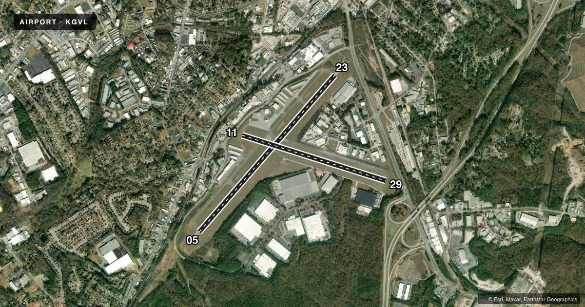
Airport sketch
Runways drawn to scale from FAA survey coordinates, rendered over satellite imagery. Not for navigation.
Approaches & charts
ILS · 1
Services on the field
Fuel grades, oxygen, maintenance, ramp storage and lighting — as declared to the FAA by the airport operator.
Fuel & services
- Fuel
- 100LLA+
- Oxygen (bottled)
- Not available
- Oxygen (bulk)
- High pressure
- Airframe repair
- Major
- Power plant repair
- Minor
- Other services
- CHTR,INSTR,RNTL,SALES
Ramp & ground
- Transient storage
- Tie-down
- Landing fee
- No fee published
- Customs
- Not available
- Lighting schedule
- SEE RMK
- Beacon schedule
- SS-SR
- Beacon
- White / Green (civil land)(WG)
- Wind indicator
- Lighted
- Segmented circle
- Yes
Fuel & FBOs
Cheapest 100LL and Jet A on the field and nearby. Always confirm with the FBO before taxi.
Airport notes
Surface conditions, obstructions, local procedures, lighting outages and other notes published with each FAA cycle.
General notes
- DEER ON & INVOF ALL RYS.
- FOR CD IF UNA TO CTC ON FSS FREQ, CTC ATLANTA APCH AT 678-364-6131, WHEN ATCT CLSD CTC ATLANTA ARTCC AT 770-210-7692.
Lighting notes
- DUSK-DAWN. ACTVT MALSR RWY 05; HIRL RWY 05/23 - CTAF.
Fuel notes
- 100LL24 HOUR SELF SERVICE FUEL WITH CREDIT CARD.
Approach & departure obstructions
- 23BLDG 360 FT LEFT 0 FT - 80 FT FROM EOR.
- 23APCH 32:1 TO DSPLCD THLD.
VFR map & nearby airports
VFR sectional. Tap any ICAO chip to open that airport.
Key facts · KGVL
Answer card- ICAO
- KGVL
- Name
- LEE GILMER MEML
- Location
- GAINESVILLE, GEORGIA
- Elevation
- 1,276.9 ft MSL
- Traffic pattern altitude
- 2,276.9 ft MSL (1,000 AGL)
- Control tower
- Non-towered (use CTAF)
- Total runways
- 2
- Longest runway
- 05/23 · 5,496 ft
- Published ILS approaches
- 1
- Published frequencies
- 4
- Magnetic variation
- 3°
- Current flight rules
- VFR
- Current wind
- 300° at 3 kt
- Favored runway now
- RWY 29
Lee Gilmer Memorial Airport is in Gainesville, Georgia. The field elevation is 1,276.9 ft MSL. It has two asphalt runways. The longest is Runway 05/23 at 5,496 ft. Runway 11/29 is 4,003 ft. There is no control tower. CTAF and UNICOM are both 123.075. Approach and departure service is handled by Atlanta on 132.475 and 291.1.
The airport has one ILS approach for Runway 05. Pattern altitude is not published, so use standard 1,000 ft AGL for light piston operations unless current local guidance says otherwise. The published remarks matter here. Runway 05 has medium intensity approach lighting with runway alignment lights from dusk to dawn. High intensity runway lights are available on Runways 05 and 23. They are controlled on CTAF. There is also 24-hour self-service 100LL with credit card. Deer are present on and near all runways. Runway 23 has a displaced threshold with a steep approach slope. A building sits close to the runway environment near that end. Give that side extra attention on short final.
Champion Aviation Services is on the field. It carries 100LL, Jet A and Jet A Prist. Lanier Flight Center is also on the field. It carries 100LL. For first-time arrivals, plan for a non-towered airport with active approach support, night lighting on Runway 05 and wildlife awareness on every movement area.