METAR & TAF KJCA
Current METAR
Observed 10:35Z
KJCA 271035Z AUTO 27004KT 10SM CLR 23/23 A2991 RMK AO2 T02310228
- Wind
- 270° @ 4 kt
- Visibility
- 10 SM
- Temp / Dew
- 23°C / 23°C
- Altimeter
- 29.91 inHg
- Clouds
- CLR
- Density alt
- 2,151 ft
- Ceiling
- Unlimited
- Rules
- VFR
Airport info & contacts
Manager on record, flight service, ARTCC, attendance schedule and pattern altitude — published by the FAA and refreshed every 28 days.
Location
- From city
- 3 NM NE
- VFR sectional
- ATLANTA
- ARTCC
- ZTL · ATLANTA
- NOTAM facility
- MCN (NOTAM-D)
Airport manager
- Name
- TOM STRONG
- Phone
- 706-367-1493
- Address
- 1562 AIRPORT RD, JEFFERSON GA 30549
Flight service · Hours
- FSS MCN
- MACON1-800-WX-BRIEF
- Attendance
- MON-FRI · 0800-1700
Frequencies
Tap any row to copy the frequency to your clipboard.
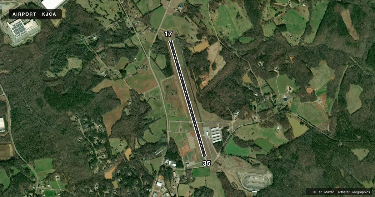
Runways & pattern
Full pagePattern entry · RWY 35
LEFT TRAFFICRunway end performance
| End | TORA | TODA | ASDA | LDA | VGSI | Approach lights | Obstruction |
|---|---|---|---|---|---|---|---|
| 17 | — | — | — | — | PAPI 2-box left(3°) | — | 91', trees, 1313' from thr, 400' R of cntrln, slope 12 |
| 35 | — | — | — | — | PAPI 2-box left(3°) | — | 43', trees, 837' from thr, 294' R of cntrln, slope 14 |
Declared distances in feet. TORA = takeoff run available, TODA = takeoff distance, ASDA = accelerate-stop, LDA = landing distance.
Airport sketch
Runways drawn to scale from FAA survey coordinates, rendered over satellite imagery. Not for navigation.
Approaches & charts
Services on the field
Fuel grades, oxygen, maintenance, ramp storage and lighting — as declared to the FAA by the airport operator.
Fuel & services
- Fuel
- 100LLA+
- Oxygen (bottled)
- Not available
- Oxygen (bulk)
- Not available
- Airframe repair
- Major
- Power plant repair
- Minor
- Other services
- AVNCS,INSTR,RNTL
Ramp & ground
- Transient storage
- Tie-down
- Hangar
- Landing fee
- No fee published
- Customs
- Not available
- Lighting schedule
- SEE RMK
- Beacon schedule
- SS-SR
- Beacon
- White / Green (civil land)(WG)
- Wind indicator
- Lighted
- Segmented circle
- Yes
Fuel & FBOs
Cheapest 100LL and Jet A on the field and nearby. Always confirm with the FBO before taxi.
Airport notes
Surface conditions, obstructions, local procedures, lighting outages and other notes published with each FAA cycle.
General notes
- DEER ON & INVOF ARPT.
- FUEL 24 HR CREDIT CARD SVC AVBL.
- FOR APCH/DEP SVC CTC ATLANTA APCH AT 678-364-6131. WHEN ATLANTA APCH UNAVBL CTC ATLANTA ARTCC AT 770-210-7692.
Lighting notes
- MIRL RWY 17/35 PRESET ON MED INTST, TO INCR INTST AND ACTVT PAPI RWY 17 & 35 - CTAF.
VFR map & nearby airports
VFR sectional. Tap any ICAO chip to open that airport.
Key facts · KJCA
Answer card- ICAO
- KJCA
- Name
- JACKSON COUNTY
- Location
- JEFFERSON, GEORGIA
- Elevation
- 950.5 ft MSL
- Traffic pattern altitude
- 1,950.5 ft MSL (1,000 AGL)
- Control tower
- Non-towered (use CTAF)
- Total runways
- 1
- Longest runway
- 17/35 · 5,010 ft
- Published ILS approaches
- 0
- Published frequencies
- 4
- Magnetic variation
- 5°
- Current flight rules
- VFR
- Current wind
- 270° at 4 kt
- Favored runway now
- RWY 35
Jackson County Airport sits in Jefferson, Georgia. Field elevation is 950.5 ft MSL. The airport has one runway. Runway 17/35 is 5,010 ft long and asphalt. The field is non-towered. Atlanta Approach handles approach and departure service. Published remarks say to call Atlanta Approach at 678-364-6131. If that service is unavailable, call Atlanta ARTCC at 770-210-7692.
No ILS approaches are published here. Pattern altitude is not published. Use the standard 1,000 ft AGL pattern for light piston traffic unless the current Chart Supplement says otherwise. The airport carries 100LL and Jet A at the on-field Jackson County Airport FBO. Fuel is available 24 hours with credit card service. Deer are on and near the airport. Keep a sharp scan on taxi, takeoff and landing.
Runway edge lights on 17/35 are preset. CTAF is used to raise intensity and activate the PAPI for runways 17 and 35. That matters at night or in low visibility. This is a good field to brief before arrival. Check the current Chart Supplement for any noise or curfew restrictions before flying in. Also verify current approach service and lighting status if you are arriving after hours.