METAR & TAF KMLJ
Current METAR
Observed 12:35Z
KMLJ 271235Z AUTO 00000KT 10SM CLR 26/25 A2988 RMK AO2
- Wind
- 000° @ 0 kt
- Visibility
- 10 SM
- Temp / Dew
- 26°C / 25°C
- Altimeter
- 29.88 inHg
- Clouds
- CLR
- Density alt
- 1,847 ft
- Ceiling
- Unlimited
- Rules
- VFR
Airport info & contacts
Manager on record, flight service, ARTCC, attendance schedule and pattern altitude — published by the FAA and refreshed every 28 days.
Location
- From city
- 4 NM N
- VFR sectional
- ATLANTA
- ARTCC
- ZTL · ATLANTA
- NOTAM facility
- MCN (NOTAM-D)
Airport manager
- Name
- BRUCE HOOD
- Phone
- 478-457-4228
- Address
- 216 AIRPORT ROAD, MILLEDGEVILLE GA 31061
Flight service · Hours
- FSS MCN
- MACON1-800-WX-BRIEF
- Attendance
- MON - SAT · 0800-1700
- SUN · BY PREARRANGEMENT
Frequencies
Tap any row to copy the frequency to your clipboard.
Runways & pattern
Full pagePattern entry · RWY 10
LEFT TRAFFICRunway end performance
| End | TORA | TODA | ASDA | LDA | VGSI | Approach lights | Obstruction |
|---|---|---|---|---|---|---|---|
| 10 | 5,506' | 5,506' | 5,506' | 5,506' | PAPI 2-box left(3°) | MALSF | 132', trees, 2940' from thr, 534' R of cntrln, slope 20 |
| 28 | 5,506' | 5,506' | 5,506' | 5,424' | PAPI 2-box left(3°) | — | 7', road, 279' from thr, 261' R of cntrln, slope 11 |
Declared distances in feet. TORA = takeoff run available, TODA = takeoff distance, ASDA = accelerate-stop, LDA = landing distance.
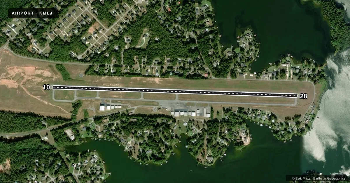
Airport sketch
Runways drawn to scale from FAA survey coordinates, rendered over satellite imagery. Not for navigation.
Approaches & charts
Services on the field
Fuel grades, oxygen, maintenance, ramp storage and lighting — as declared to the FAA by the airport operator.
Fuel & services
- Fuel
- 100LLA+
- Oxygen (bottled)
- Not available
- Oxygen (bulk)
- Not available
- Airframe repair
- Not available
- Power plant repair
- Not available
- Other services
- INSTR,RNTL
Ramp & ground
- Transient storage
- Tie-down
- Landing fee
- No fee published
- Customs
- Not available
- Lighting schedule
- SEE RMK
- Beacon schedule
- SS-SR
- Beacon
- White / Green (civil land)(WG)
- Wind indicator
- Lighted
- Segmented circle
- Yes
Fuel & FBOs
Cheapest 100LL and Jet A on the field and nearby. Always confirm with the FBO before taxi.
Airport notes
Surface conditions, obstructions, local procedures, lighting outages and other notes published with each FAA cycle.
General notes
- DEER, GEESE, COYOTES, AND BIRDS ON AND INVOF ARPT.
- FOR CD CTC ATLANTA APCH AT 678-364-6132, WHEN APCH CLSD CTC ATLANTA ARTCC AT 770-210-7692.
- NO FIXED WING ACFT PRKG WI 100 FT OF FUEL TANK.
- EXTSV FLT TRNG ON AND INVOF ARPT.
- FLW FBO INSTRN FOR PRKG DUE TO TIGHT RAMP AREA.
- BEARS RPRTD W OF RWY, USE CTN.
- EXTSV BIRD ACT NEAR AER 10/28 FEB TO OCT DRG DALGT HRS.
- TPA - LIGHT ACFT 1400 MSL, HEAVY ACFT 1900 MSL.
- AMEL - EXP MARSHALLER UPON ENTERING MAIN RAMP.
- RT - REFER TO FBO FOR PRKG.
- ALL FIXED WING ACFT SHALL LVE PRKG BRAKE OFF IN CASE OF TOWING.
- NO PUB PRKG AT W RAMP AND HNGRS.
Lighting notes
- LCTD MID FIELD BESIDE FBO SOUTH OF TWY.
- ATCTVT MALSF RWY 10; REIL RWY 28; PAPI RWY 10 & 28; MIRL RWY 10/28 ARE PRESET ON MED INTST DUSK-2200; TO INCR INTST AND ACTVT AFTER 2200 - CTAF.
Runway surface & condition
- 10/28PCR VALUE: 237/F/C/X/T
Other notes
- FLW HI WING, LOW WING, HI WING SEQ.
- WIND INDCR LCTD N OF RWY 10 TDZ, ACTVT WIND INDCR LGT - CTAF.
- MANAGERALTN NR: 478-453-9358.
VFR map & nearby airports
VFR sectional. Tap any ICAO chip to open that airport.
Key facts · KMLJ
Answer card- ICAO
- KMLJ
- Name
- BALDWIN COUNTY RGNL
- Location
- MILLEDGEVILLE, GEORGIA
- Elevation
- 384.9 ft MSL
- Traffic pattern altitude
- 1,384.9 ft MSL (1,000 AGL)
- Control tower
- Non-towered (use CTAF)
- Total runways
- 1
- Longest runway
- 10/28 · 5,506 ft
- Published ILS approaches
- 0
- Published frequencies
- 5
- Magnetic variation
- 4°
- Current flight rules
- VFR
- Current wind
- 000° at 0 kt
- Favored runway now
- –
Baldwin County Rgnl (KMLJ) is in Milledgeville, Georgia. The field elevation is 384.9 ft MSL. It has one runway, 10/28, at 5,506 ft. There is no control tower. The airport uses Atlanta Approach for radar services, with CTAF and UNICOM on 122.975.
No ILS approaches are published here. The published pattern altitude for light aircraft is 1,400 ft MSL. The runway lighting is pilot controlled. Runway 10 has medium intensity approach lights with sequenced flashers. Runway 28 has REILs. PAPI is published on both ends. Lights are preset medium from dusk to 2200. Use CTAF to raise intensity after 2200.
Sinclair Aviation is on the field. It carries 100LL and JET A. Refer to the FBO for parking. Expect a marshaller on the main ramp. The remarks also call out bird activity near runway 10/28 from February through October in daylight. Deer, geese, coyotes and birds are also reported near the airport. That makes a careful taxi and takeoff scan important here. For clearance delivery, contact Atlanta Approach. If approach is closed, contact Atlanta ARTCC. Check the current FAA Chart Supplement for any updated procedures before you go.