METAR & TAF 2J3
2J3 does not publish a METAR.
Showing the nearest reporting station: KSBO (EAST GEORGIA RGNL) · 22.6 NM away. Conditions at 2J3 may differ.
METAR · KSBO
Observed 13:15Z
KSBO 271315Z AUTO 30004KT 10SM CLR 26/25 A2990 RMK AO2
- Wind
- 300° @ 4 kt
- Visibility
- 10 SM
- Temp / Dew
- 26°C / 25°C
- Altimeter
- 29.90 inHg
- Clouds
- CLR
- Density alt
- 1,751 ft
- Ceiling
- Unlimited
- Rules
- VFR
Airport info & contacts
Manager on record, flight service, ARTCC, attendance schedule and pattern altitude — published by the FAA and refreshed every 28 days.
Location
- From city
- 2 NM SE
- VFR sectional
- ATLANTA
- ARTCC
- ZTL · ATLANTA
- NOTAM facility
- MCN (NOTAM-D)
Airport manager
- Name
- RICHARD SAPP
- Phone
- 478-625-3166
- Address
- PO BOX 527, LOUISVILLE GA 30434
Flight service · Hours
- FSS MCN
- MACON1-800-WX-BRIEF
- Attendance
- Unattended
Frequencies
Tap any row to copy the frequency to your clipboard.
Runways & pattern
Full pagePattern entry · RWY 31
LEFT TRAFFICRunway end performance
| End | TORA | TODA | ASDA | LDA | VGSI | Approach lights | Obstruction |
|---|---|---|---|---|---|---|---|
| 13 | — | — | — | — | PAPI 2-box left(3.83°) | — | 55', trees, 835' from thr, 343' R of cntrln, slope 11 |
| 31 | — | — | — | — | PAPI 2-box left(3.65°) | — | 20', trees, 671' from thr, 184' R of cntrln, slope 23 |
Declared distances in feet. TORA = takeoff run available, TODA = takeoff distance, ASDA = accelerate-stop, LDA = landing distance.
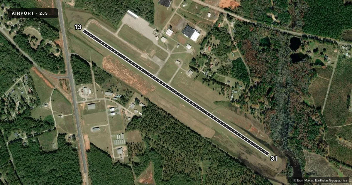
Airport sketch
Runways drawn to scale from FAA survey coordinates, rendered over satellite imagery. Not for navigation.
Approaches & charts
Services on the field
Fuel grades, oxygen, maintenance, ramp storage and lighting — as declared to the FAA by the airport operator.
Fuel & services
- Fuel
- 100LLA+
- Oxygen (bottled)
- Not available
- Oxygen (bulk)
- Not available
- Airframe repair
- Major
- Power plant repair
- Major
Ramp & ground
- Transient storage
- Tie-down
- Landing fee
- No fee published
- Customs
- Not available
- Lighting schedule
- SEE RMK
- Beacon schedule
- SS-SR
- Beacon
- White / Green (civil land)(WG)
- Wind indicator
- Lighted
- Segmented circle
- Yes
Fuel & FBOs
Cheapest 100LL and Jet A on the field and nearby. Always confirm with the FBO before taxi.
Airport notes
Surface conditions, obstructions, local procedures, lighting outages and other notes published with each FAA cycle.
General notes
- FOR CD CTC AUGUSTA APCH AT 706-771-1777, WHEN APCH CLSD CTC ATLANTA ARTCC AT 770-210-7692..
- CALL AMGR - 478-625-3166 - FOR COURTESY CAR
Lighting notes
- ACTVT PAPI RWY 13 & 31; MIRL RWY 13/31- CTAF.
VFR map & nearby airports
VFR sectional. Tap any ICAO chip to open that airport.
Key facts · 2J3
Answer card- ICAO
- 2J3
- Name
- LOUISVILLE MUNI
- Location
- LOUISVILLE, GEORGIA
- Elevation
- 327.9 ft MSL
- Traffic pattern altitude
- 1,327.9 ft MSL (1,000 AGL)
- Control tower
- Non-towered (use CTAF)
- Total runways
- 1
- Longest runway
- 13/31 · 5,002 ft
- Published ILS approaches
- 0
- Published frequencies
- 3
- Magnetic variation
- 3°
- Current flight rules
- VFR
- Current wind
- 300° at 4 kt
- Favored runway now
- RWY 31
Louisville Muni sits in Louisville, Georgia. The field elevation is 327.9 ft MSL. It has one runway. Runway 13/31 is 5,002 ft of asphalt, so it gives light aircraft a straightforward option for local flying and cross-country stops. There is no control tower. CTAF is 122.9. Augusta Approach handles clearance delivery on 126.8 or 270.3, depending on the side of the sector. Atlanta ARTCC is the backup when approach is closed.
No ILS approaches are published here. Pattern altitude is not published, so use the standard 1,000 ft AGL for light piston traffic unless the current Chart Supplement says otherwise. The airport has one on-field FBO, Louisville Municipal Airport. It carries 100LL and Jet A. Call the airport manager at (478) 625-3166 if you need the courtesy car. Runway 13 and 31 have PAPI. Medium intensity runway lights are also on 13 and 31. They are controlled by CTAF. That makes after-hours operations possible, but you should verify lighting use and any local procedures before you go. For a first visit, the main things to plan around are the non-towered pattern, the published lighting on the single runway and the approach coordination if you need IFR handling.