METAR & TAF KAGS
Current METAR
Observed 12:53Z
KAGS 271253Z 00000KT 10SM CLR 27/24 A2986 RMK AO2 SLP108 T02670244
- Wind
- 000° @ 0 kt
- Visibility
- 10 SM
- Temp / Dew
- 27°C / 24°C
- Altimeter
- 29.86 inHg
- Clouds
- CLR
- Density alt
- 1,695 ft
- Ceiling
- Unlimited
- Rules
- VFR
Airport info & contacts
Manager on record, flight service, ARTCC, attendance schedule and pattern altitude — published by the FAA and refreshed every 28 days.
Location
- From city
- 6 NM S
- VFR sectional
- ATLANTA
- ARTCC
- ZTL · ATLANTA
- NOTAM facility
- AGS (NOTAM-D)
Airport manager
- Name
- HERBERT JUDON
- Phone
- 706-798-3236
- Address
- 1501 AVIATION WAY, AUGUSTA GA 30906
Flight service · Hours
- FSS MCN
- MACON1-800-WX-BRIEF
- Attendance
- ALL
Frequencies
Tap any row to copy the frequency to your clipboard.
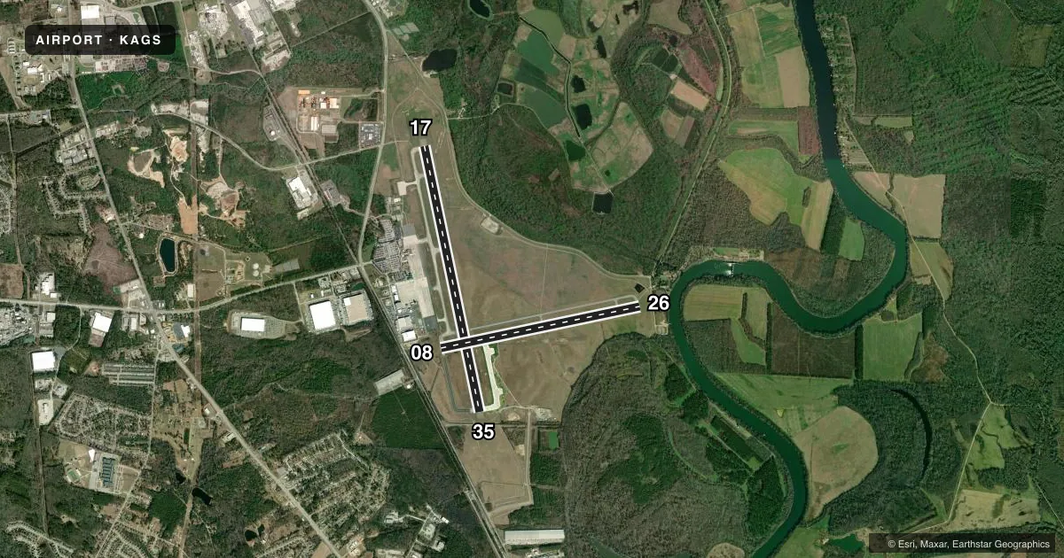
Runways & pattern
Full pagePattern entry · RWY 17
LEFT TRAFFIC| Runway | Heading (°M) | Length | Surface | Traffic |
|---|---|---|---|---|
| 17/35 | 164° / 344° | 8,001 ft | CONC | Standard L |
| 08/26 | 74° / 254° | 6,001 ft | ASPH | Standard L |
Runway end performance
| End | TORA | TODA | ASDA | LDA | VGSI | Approach lights | Obstruction |
|---|---|---|---|---|---|---|---|
| 17 | — | — | — | — | PAPI 4-box left(3°) | MALSR | 90', tree, 2450' from thr, 800' R of cntrln, slope 38 |
| 35 | — | — | — | — | PAPI 4-box left(3°) | MALSR | 42', trees, 1500' from thr, 600' R of cntrln, slope 21 |
| 08 | — | — | — | — | PAPI 4-box left(3°) | — | 52', trees, 1250' from thr, 125' R of cntrln, slope 20 |
| 26 | — | — | — | — | PAPI 4-box left(3°) | — | 65', trees, 1250' from thr, 200' R of cntrln, slope 16 |
Declared distances in feet. TORA = takeoff run available, TODA = takeoff distance, ASDA = accelerate-stop, LDA = landing distance.
Airport sketch
Runways drawn to scale from FAA survey coordinates, rendered over satellite imagery. Not for navigation.
Approaches & charts
ILS · 2
Services on the field
Fuel grades, oxygen, maintenance, ramp storage and lighting — as declared to the FAA by the airport operator.
Fuel & services
- Fuel
- 100LLA
- Oxygen (bottled)
- HIGH/LOW
- Oxygen (bulk)
- HIGH/LOW
- Airframe repair
- Major
- Power plant repair
- Major
- Other services
- AMB,AVNCS,CARGO,CHTR,RNTL,SALES
Ramp & ground
- Transient storage
- Tie-down
- Hangar
- Landing fee
- No fee published
- Customs
- Not available
- Lighting schedule
- SEE RMK
- Beacon schedule
- SS-SR
- Beacon
- White / Green (civil land)(WG)
- Wind indicator
- Yes
- Segmented circle
- Yes
Fuel & FBOs
Cheapest 100LL and Jet A on the field and nearby. Always confirm with the FBO before taxi.
Airport notes
Surface conditions, obstructions, local procedures, lighting outages and other notes published with each FAA cycle.
General notes
- BIRDS ON & INVOF ARPT. HVY BIRD ACT INVOF ARPT NOV-MAR.
- CAUTION: TAXI-LANE RAMP ENTRANCE/EXIT POINT INTO STANDARD AERO STORM WATER DITCH ON NORTH SIDE.
- CAUTION: WILDLIFE HAZARD COYOTE.
- FOR CD IF UNA TO CTC ON FSS FREQ, CTC AUGUSTA APCH AT 706-771-1777, WHEN APCH CLSD CTC ATLANTA ARTCC AT 770-210-7692.
- TOUCH AND GO OPS UNAVBL FOR ACFT OVER 12500 LBS.
Lighting notes
- PAPI RWYS 08, 17, 26 & 35, OPER CONSLY. REIL RWY 08 & 26; MIRL RWY 08/26; HIRL RWY 17/35 OPER CONSLY WHEN ATCT CLSD. ACTVT MALSR RWY 17 & 35 - CTAF.
Runway surface & condition
- 17/352T-585K (B-C-17), 2D/2D2-975K (747), 840K (C-5) 2D/2D2-975K (747).
- 17/352S-175.
- 08/26PCR VALUE: 120/F/B/X/T
- 17/35PCR VALUE: 930/R/B/W/T
Approach & departure obstructions
- 35PER SURVEY DEC 2004 RWY 17-35.
Other notes
- EXISTED PRIOR TO 1959.
- ARFF INDEX C AVBL UPON REQUEST. ARFF INDEX D AVBL WITH 48 HR NOTICE.
VFR map & nearby airports
VFR sectional. Tap any ICAO chip to open that airport.
Key facts · KAGS
Answer card- ICAO
- KAGS
- Name
- AUGUSTA RGNL AT BUSH FLD
- Location
- AUGUSTA, GEORGIA
- Elevation
- 145.7 ft MSL
- Traffic pattern altitude
- 1,145.7 ft MSL (1,000 AGL)
- Control tower
- Towered · 0645-2300
- Total runways
- 2
- Longest runway
- 17/35 · 8,001 ft
- Published ILS approaches
- 2
- Published frequencies
- 18
- Magnetic variation
- 4°
- Current flight rules
- VFR
- Current wind
- 000° at 0 kt
- Favored runway now
- –
Augusta Regional at Bush Field sits in Augusta, Georgia. The field elevation is 145.7 ft MSL. KAGS has two runways. The longest is 17/35 at 8,001 ft. Runway 08/26 is 6,001 ft. The tower is open daily from 0645 to 2300.
This field has two ILS approaches. They are on runway ends 17 and 35. Pattern altitude is not published in the facts, so use the standard 1,000 ft AGL for light piston traffic unless ATC or the current Chart Supplement says otherwise. Augusta Regional is a busy towered field with TRSA service and published approach control. Expect normal coordination on arrival and departure.
Augusta Regional Airport Aviation Services is on the field. It carries 100LL, Jet A and Jet A Prist. The airport remarks call out birds in the area. Heavier bird activity is noted from November through March. They also note coyotes as a wildlife hazard. There is also a caution about the taxi-lane ramp entrance and exit point into the Standard Aero storm water ditch on the north side. Runway lighting and approach lighting are published for both runway pairs, so night ops are supported. If you need clearance delivery after FSS contact is not available, the Chart Supplement gives alternate phone numbers for Augusta Approach and Atlanta Center.