METAR & TAF KBXG
KBXG does not publish a METAR.
Showing the nearest reporting station: KAGS (AUGUSTA RGNL AT BUSH FLD) · 19.9 NM away. Conditions at KBXG may differ.
METAR · KAGS
Observed 05:53Z
KAGS 270553Z AUTO 00000KT 7SM FEW060 24/24 A2987 RMK AO2 SLP114 T02440244 10317 20244 50003
- Wind
- 000° @ 0 kt
- Visibility
- 7 SM
- Temp / Dew
- 24°C / 24°C
- Altimeter
- 29.87 inHg
- Clouds
- FEW
- Density alt
- 1,525 ft
- Ceiling
- Unlimited
- Rules
- VFR
Airport info & contacts
Manager on record, flight service, ARTCC, attendance schedule and pattern altitude — published by the FAA and refreshed every 28 days.
Location
- From city
- 3 NM S
- VFR sectional
- ATLANTA
- ARTCC
- ZTL · ATLANTA
- NOTAM facility
- MCN (NOTAM-D)
Airport manager
- Name
- ADAM FLAKES
- Phone
- 706-554-5270
- Address
- PO BOX 89, WAYNESBORO GA 30830
Flight service · Hours
- FSS MCN
- MACON1-800-WX-BRIEF
- Attendance
- M-F · 0900-1700
Frequencies
Tap any row to copy the frequency to your clipboard.
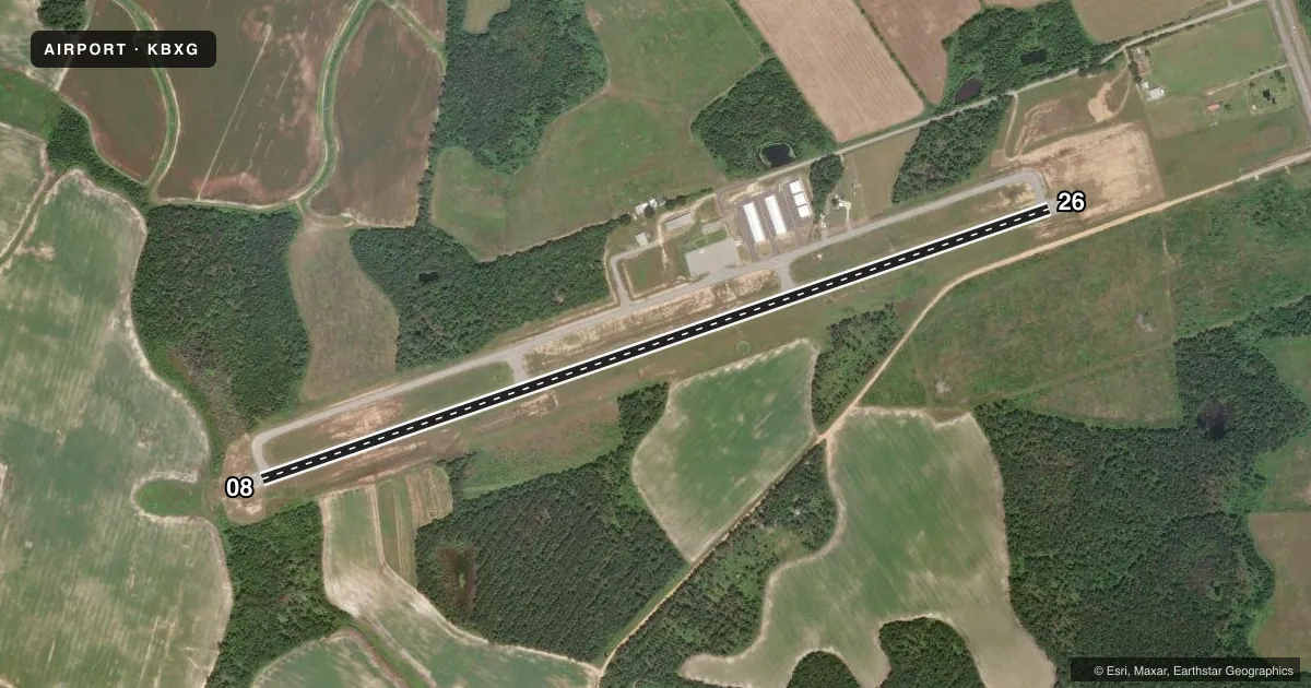
Runways & pattern
Full pagePattern entry · RWY 08
LEFT TRAFFICRunway end performance
| End | TORA | TODA | ASDA | LDA | VGSI | Approach lights | Obstruction |
|---|---|---|---|---|---|---|---|
| 08 | 5,003' | 5,003' | 5,003' | 5,003' | PAPI 2-box left(3°) | — | 55', trees, 288' from thr, 246' R of cntrln, slope 1 |
| 26 | 5,003' | 5,003' | 5,003' | 4,903' | PAPI 2-box right(3°) | — | 35', pole, 500' from thr, 264' R of cntrln, slope 8 |
Declared distances in feet. TORA = takeoff run available, TODA = takeoff distance, ASDA = accelerate-stop, LDA = landing distance.
Airport sketch
Runways drawn to scale from FAA survey coordinates, rendered over satellite imagery. Not for navigation.
Approaches & charts
Services on the field
Fuel grades, oxygen, maintenance, ramp storage and lighting — as declared to the FAA by the airport operator.
Fuel & services
- Fuel
- 100LLA+
- Oxygen (bottled)
- Not available
- Oxygen (bulk)
- Not available
- Airframe repair
- Not available
- Power plant repair
- Not available
- Other services
- AGRI
Ramp & ground
- Transient storage
- Tie-down
- Landing fee
- No fee published
- Customs
- Not available
- Lighting schedule
- SEE RMK
- Beacon schedule
- SS-SR
- Beacon
- White / Green (civil land)(WG)
- Wind indicator
- Lighted
- Segmented circle
- Yes
Fuel & FBOs
Cheapest 100LL and Jet A on the field and nearby. Always confirm with the FBO before taxi.
Airport notes
Surface conditions, obstructions, local procedures, lighting outages and other notes published with each FAA cycle.
General notes
- DEER ON & INVOF ARPT.
- FOR CD CTC AUGUSTA APCH AT 706-771-1777, WHEN APCH CLSD CTC ATLANTA ARTCC 770-210-7692.
Lighting notes
- ACTVT REIL RWY 08; PAPI RWY 08 & 26; MIRL RWY 08/26 - CTAF.
Other notes
- MANAGERCOUNTY ADMINISTRATOR.
- MANAGERARPT PHONE 706-554-5270.
VFR map & nearby airports
VFR sectional. Tap any ICAO chip to open that airport.
Key facts · KBXG
Answer card- ICAO
- KBXG
- Name
- BURKE COUNTY
- Location
- WAYNESBORO, GEORGIA
- Elevation
- 308.7 ft MSL
- Traffic pattern altitude
- 1,308.7 ft MSL (1,000 AGL)
- Control tower
- Non-towered (use CTAF)
- Total runways
- 1
- Longest runway
- 08/26 · 5,003 ft
- Published ILS approaches
- 0
- Published frequencies
- 3
- Magnetic variation
- 4°
- Current flight rules
- VFR
- Current wind
- 000° at 0 kt
- Favored runway now
- –
Burke County Airport sits in Waynesboro, Georgia. Field elevation is 308.7 ft MSL. The airport has one runway. Runway 08/26 is 5,003 ft of asphalt. There is no control tower. VFR operations only are published here. No ILS approaches are published, so plan for visual work and current weather awareness before you go.
The pattern altitude is not published. Use 1,000 ft AGL for light piston traffic unless the current Chart Supplement says otherwise. Runway 08 has REIL lighting. PAPI is available on runways 08 and 26. Medium intensity runway lighting is available on both ends and is controlled by CTAF. That helps for night arrivals. You still need to self-announce and stay sharp on the radio.
There are no on-field FBOs listed in the facts, so verify fuel and services with the airport operator or call the field directly before arrival. For clearance delivery, contact Augusta Approach at 706-771-1777. When approach is closed, contact Atlanta ARTCC at 770-210-7692. Deer are on and near the airport, so keep a close scan on taxi, takeoff and landing. The airport manager is the County Administrator.