METAR & TAF KJYL
Current METAR
Observed 12:35Z
KJYL 271235Z AUTO 00000KT 4SM BR CLR 24/24 A2989 RMK AO2 T02370237
- Wind
- 000° @ 0 kt
- Visibility
- 4 SM
- Temp / Dew
- 24°C / 24°C
- Altimeter
- 29.89 inHg
- Clouds
- CLR
- Density alt
- 1,353 ft
- Ceiling
- Unlimited
- Rules
- MVFR
Airport info & contacts
Manager on record, flight service, ARTCC, attendance schedule and pattern altitude — published by the FAA and refreshed every 28 days.
Location
- From city
- 7 NM S
- VFR sectional
- ATLANTA
- ARTCC
- ZJX · JACKSONVILLE
- NOTAM facility
- MCN (NOTAM-D)
Airport manager
- Name
- HANK MAIERHOFFER
- Phone
- 912-857-3220
- Address
- 538 BEACON ROAD, SYLVANIA GA 30467
Flight service · Hours
- FSS MCN
- MACON1-800-WX-BRIEF
- Attendance
- 0800-1700
Frequencies
Tap any row to copy the frequency to your clipboard.
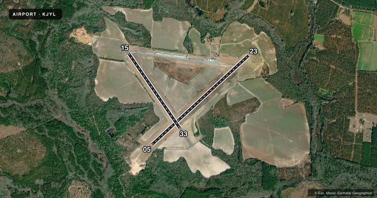
Runways & pattern
Full pagePattern entry · RWY 05
RIGHT TRAFFIC| Runway | Heading (°M) | Length | Surface | Traffic |
|---|---|---|---|---|
| 05/23 | 40° / 220° | 5,501 ft | ASPH | 05 R |
| 15/33 | 138° / 318° | 3,787 ft | ASPH | 15 R |
Runway end performance
| End | TORA | TODA | ASDA | LDA | VGSI | Approach lights | Obstruction |
|---|---|---|---|---|---|---|---|
| 05 | — | — | — | — | PAPI 2-box left(3°) | — | 30', trees, 971' from thr, 336' R of cntrln, slope 25 |
| 23 | — | — | — | — | PAPI 2-box left(3°) | — | 32', trees, 908' from thr, 467' R of cntrln, slope 22 |
| 15 | — | — | — | — | — | — | 65', trees, 1596' from thr, 259' R of cntrln, slope 21 |
Declared distances in feet. TORA = takeoff run available, TODA = takeoff distance, ASDA = accelerate-stop, LDA = landing distance.
Airport sketch
Runways drawn to scale from FAA survey coordinates, rendered over satellite imagery. Not for navigation.
Approaches & charts
Services on the field
Fuel grades, oxygen, maintenance, ramp storage and lighting — as declared to the FAA by the airport operator.
Fuel & services
- Fuel
- 100LLA+
- Oxygen (bottled)
- Not available
- Oxygen (bulk)
- Not available
- Airframe repair
- Major
- Power plant repair
- Major
- Other services
- AGRI,PAJA
Ramp & ground
- Transient storage
- Tie-down
- Landing fee
- No fee published
- Customs
- Not available
- Lighting schedule
- SEE RMK
- Beacon schedule
- SS-SR
- Beacon
- White / Green (civil land)(WG)
- Wind indicator
- Lighted
- Segmented circle
- Yes
Fuel & FBOs
Cheapest 100LL and Jet A on the field and nearby. Always confirm with the FBO before taxi.
Airport notes
Surface conditions, obstructions, local procedures, lighting outages and other notes published with each FAA cycle.
General notes
- DEER ON & INVOF ARPT.
- FOR CD CTC JACKSONVILLE ARTCC AT 904-845-1592.
- MIL OPN RQR 24 HR PPR AT 912-687-0653.
Lighting notes
- MIRL RWY 05/23 PRESET LOW INTST DUSK-0100, TO INCR INTST AND ACTVT AFTER 0100 - CTAF. PAPI RWY 05 & 23 - CTAF.
Fuel notes
- 100LLFUEL 24 HR CREDIT CARD SVC AVBL.
Other notes
- ARPT CONSTRUCTED PRIOR TO 1958.
- MANAGERALT PHONE 912-682-9313.
VFR map & nearby airports
VFR sectional. Tap any ICAO chip to open that airport.
Key facts · KJYL
Answer card- ICAO
- KJYL
- Name
- PLANTATION AIRPARK
- Location
- SYLVANIA, GEORGIA
- Elevation
- 190.3 ft MSL
- Traffic pattern altitude
- 1,190.3 ft MSL (1,000 AGL)
- Control tower
- Non-towered (use CTAF)
- Total runways
- 2
- Longest runway
- 05/23 · 5,501 ft
- Published ILS approaches
- 0
- Published frequencies
- 2
- Magnetic variation
- 7°
- Current flight rules
- MVFR
- Current wind
- 000° at 0 kt
- Favored runway now
- –
Plantation Airpark is in Sylvania, Georgia. Field elevation is 190.3 ft MSL. The airport has two asphalt runways. The longest is 5,501 ft on runway 05/23. Runway 15/33 is 3,787 ft. There is no control tower, so expect self-announce traffic on CTAF 122.8. Pattern altitude is not published, so use the standard 1,000 ft AGL for light piston operations unless the current Chart Supplement says otherwise.
No ILS approaches are published here. Aeroborne Enterprises is on the field. It carries 100LL and Jet A. Fuel is available 24 hours with credit card service. The runway lighting on 05/23 is preset to low intensity from dusk to 0100. After 0100, use the CTAF to increase intensity and activate the lights. The PAPI on 05 and 23 is also controlled by CTAF.
A first-time pilot should watch for deer in and near the airport. Military operations need 24-hour prior permission. Clearance delivery is handled through Jacksonville ARTCC. This is a non-towered field with a long primary runway, so plan for normal local traffic discipline and verify current procedures in the FAA Chart Supplement before departure.