METAR & TAF KMHP
Current METAR
Observed 13:15Z
KMHP 271315Z AUTO 30004KT 10SM CLR 27/26 A2988 RMK AO2 T02740257
- Wind
- 300° @ 4 kt
- Visibility
- 10 SM
- Temp / Dew
- 27°C / 26°C
- Altimeter
- 29.88 inHg
- Clouds
- CLR
- Density alt
- 1,734 ft
- Ceiling
- Unlimited
- Rules
- VFR
Airport info & contacts
Manager on record, flight service, ARTCC, attendance schedule and pattern altitude — published by the FAA and refreshed every 28 days.
Location
- From city
- 2 NM S
- VFR sectional
- ATLANTA
- ARTCC
- ZJX · JACKSONVILLE
- NOTAM facility
- MCN (NOTAM-D)
Airport manager
- Name
- CLIFF HENDRIX
- Phone
- 912-536-5909
- Address
- METTER-CANDLER AIRPORT AUTHORITY, 25 S. TERRELL STREET, METTER GA 30439
Flight service · Hours
- FSS MCN
- MACON1-800-WX-BRIEF
- Attendance
- UNATTENDED
Frequencies
Tap any row to copy the frequency to your clipboard.
Runways & pattern
Full pagePattern entry · RWY 28
LEFT TRAFFICRunway end performance
| End | TORA | TODA | ASDA | LDA | VGSI | Approach lights | Obstruction |
|---|---|---|---|---|---|---|---|
| 10 | — | — | — | — | PAPI 2-box right(3°) | — | 81', trees, 2565' from thr, 575' R of cntrln, slope 29 |
| 28 | — | — | — | — | PAPI 2-box left(3°) | — | 14', road, 442' from thr, 286' R of cntrln, slope 17 |
Declared distances in feet. TORA = takeoff run available, TODA = takeoff distance, ASDA = accelerate-stop, LDA = landing distance.
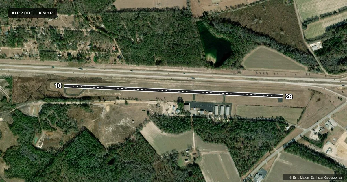
Airport sketch
Runways drawn to scale from FAA survey coordinates, rendered over satellite imagery. Not for navigation.
Approaches & charts
Services on the field
Fuel grades, oxygen, maintenance, ramp storage and lighting — as declared to the FAA by the airport operator.
Fuel & services
- Fuel
- 100LLA+
- Oxygen (bottled)
- Not available
- Oxygen (bulk)
- Not available
- Airframe repair
- Major
- Power plant repair
- Major
- Other services
- INSTR
Ramp & ground
- Transient storage
- Tie-down
- Landing fee
- No fee published
- Customs
- Not available
- Lighting schedule
- SEE RMK
- Beacon schedule
- SS-SR
- Beacon
- White / Green (civil land)(WG)
- Wind indicator
- Lighted
- Segmented circle
- Yes
Fuel & FBOs
Cheapest 100LL and Jet A on the field and nearby. Always confirm with the FBO before taxi.
Airport notes
Surface conditions, obstructions, local procedures, lighting outages and other notes published with each FAA cycle.
General notes
- FOR CD CTC JACKSONVILLE ARTCC AT 904-845-1592.
Lighting notes
- ACTVT PAPI RWY 10 & 28; REIL RWY 10; MIRL RWY 10/28 - CTAF.
Approach & departure obstructions
- 286 FT FENCE AND SHRUBS 0 FT-200 FT FM THR, 180 FT RIGHT.
Other notes
- MANAGERSECRETARY/ TREASURER.
- MANAGERARPT PHONE 912-685-4162.
VFR map & nearby airports
VFR sectional. Tap any ICAO chip to open that airport.
Key facts · KMHP
Answer card- ICAO
- KMHP
- Name
- JOHN EDWIN JONES SR FLD/METTER MUNI
- Location
- METTER, GEORGIA
- Elevation
- 197.3 ft MSL
- Traffic pattern altitude
- 1,197.3 ft MSL (1,000 AGL)
- Control tower
- Non-towered (use CTAF)
- Total runways
- 1
- Longest runway
- 10/28 · 5,001 ft
- Published ILS approaches
- 0
- Published frequencies
- 2
- Magnetic variation
- 7°
- Current flight rules
- VFR
- Current wind
- 300° at 4 kt
- Favored runway now
- RWY 28
John Edwin Jones Sr Fld/Metter Muni (KMHP) is in Metter, Georgia. The field elevation is 197.3 ft MSL. It has one runway. Runway 10/28 is 5,001 ft asphalt, which is the longest runway on the field. There is no control tower. CTAF and UNICOM are both 123.0.
No ILS approaches are published here. The pattern altitude is not published in the facts, so use the standard 1,000 ft AGL for light piston traffic unless the current Chart Supplement says otherwise. The on-field FBO is Metter Municipal Airport. It carries 100LL and Jet A. Call (912) 685-4162 for current service details before you go.
Published remarks matter here. PAPI is available for both runway ends. Runway 10 also has REIL lighting. Both runway ends have medium intensity runway lighting. There is also a reported fence and shrubs near the right side of runway 28 close to the threshold. That is worth checking in your preflight planning, especially if you are arriving at night or in low visibility. For clearance delivery, contact Jacksonville ARTCC at 904-845-1592. If you need current operational details, call the airport manager or the FBO directly before departure.