METAR & TAF KVDI
Current METAR
Observed 05:55Z
KVDI 270555Z AUTO 01016G20KT 1/2SM +RA FG OVC005 25/24 A2991 RMK AO2 LTG DSNT SW P0016 VIS 1/4V3 10272 20245
- Wind
- 010° @ 16G20 kt
- Visibility
- 0.5 SM
- Temp / Dew
- 25°C / 24°C
- Altimeter
- 29.91 inHg
- Clouds
- OVC
- Density alt
- 1,553 ft
- Ceiling
- 500 ft AGL
- Rules
- LIFR
Airport info & contacts
Manager on record, flight service, ARTCC, attendance schedule and pattern altitude — published by the FAA and refreshed every 28 days.
Location
- From city
- 3 NM SE
- VFR sectional
- ATLANTA
- ARTCC
- ZJX · JACKSONVILLE
- NOTAM facility
- VDI (NOTAM-D)
Airport manager
- Name
- BILLY RAGAN
- Phone
- 912-537-3979
- Address
- 2921 AIRPORT ROAD, VIDALIA GA 30474
Flight service · Hours
- FSS MCN
- MACON1-800-WX-BRIEF
- Attendance
- 0800-1800
Frequencies
Tap any row to copy the frequency to your clipboard.
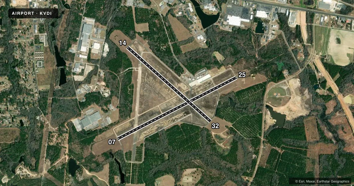
Runways & pattern
Full pagePattern entry · RWY 07
LEFT TRAFFIC| Runway | Heading (°M) | Length | Surface | Traffic |
|---|---|---|---|---|
| 07/25Favored | 57° / 237° | 6,002 ft | CONC | Standard L |
| 14/32 | 126° / 306° | 5,002 ft | CONC | Standard L |
Runway end performance
| End | TORA | TODA | ASDA | LDA | VGSI | Approach lights | Obstruction |
|---|---|---|---|---|---|---|---|
| 07 | — | — | — | — | PAPI 4-box left(3°) | — | 31', trees, 290' from thr, 490' R of cntrln, slope 2 |
| 25 | — | — | — | — | PAPI 4-box left(3°) | MALSR | 19', trees, 575' from thr, 230' R of cntrln, slope 19 |
| 14 | — | — | — | — | — | — | 27', trees, 339' from thr, 262' R of cntrln, slope 5 |
| 32 | — | — | — | — | — | — | 42', trees, 724' from thr, 240' R of cntrln, slope 12 |
Declared distances in feet. TORA = takeoff run available, TODA = takeoff distance, ASDA = accelerate-stop, LDA = landing distance.
Airport sketch
Runways drawn to scale from FAA survey coordinates, rendered over satellite imagery. Not for navigation.
Approaches & charts
ILS · 1
Services on the field
Fuel grades, oxygen, maintenance, ramp storage and lighting — as declared to the FAA by the airport operator.
Fuel & services
- Fuel
- 100LLA+
- Oxygen (bottled)
- Not available
- Oxygen (bulk)
- Not available
- Airframe repair
- Minor
- Power plant repair
- Minor
- Other services
- AGRI,INSTR,RNTL
Ramp & ground
- Transient storage
- Tie-down
- Landing fee
- No fee published
- Customs
- Not available
- Lighting schedule
- SEE RMK
- Beacon schedule
- SS-SR
- Beacon
- White / Green (civil land)(WG)
- Wind indicator
- Lighted
- Segmented circle
- No
Fuel & FBOs
Cheapest 100LL and Jet A on the field and nearby. Always confirm with the FBO before taxi.
Airport notes
Surface conditions, obstructions, local procedures, lighting outages and other notes published with each FAA cycle.
General notes
- FOR CD CTC JACKSONVILLE ARTCC AT 904-845-1592.
Lighting notes
- HIRL RWY 07/25 PRESET MED INTS DUSK-2300. AFTER 2300 ACTVT - CTAF. ACTVT MALSR RWY 25; REIL RWY 07 - CTAF. PAPI RWY 07 & 25 OPR CONSLY.
Fuel notes
- 100LLFUEL 24 HR CREDIT CARD SVC AVBL.
VFR map & nearby airports
VFR sectional. Tap any ICAO chip to open that airport.
Key facts · KVDI
Answer card- ICAO
- KVDI
- Name
- VIDALIA RGNL
- Location
- VIDALIA, GEORGIA
- Elevation
- 274.3 ft MSL
- Traffic pattern altitude
- 1,274.3 ft MSL (1,000 AGL)
- Control tower
- Non-towered (use CTAF)
- Total runways
- 2
- Longest runway
- 07/25 · 6,002 ft
- Published ILS approaches
- 1
- Published frequencies
- 2
- Magnetic variation
- 6°
- Current flight rules
- LIFR
- Current wind
- 010° at 16 kt
- Favored runway now
- RWY 07
Vidalia Rgnl is in Vidalia, Georgia. Field elevation is 274.3 ft MSL. The airport has two concrete runways. The longest is runway 07/25 at 6,002 ft. There is no control tower. CTAF and UNICOM are both 122.8.
One ILS approach is published for runway 25. Pattern altitude is not published, so use the standard 1,000 ft AGL for light piston traffic unless the current Chart Supplement says otherwise. The field sits in a non-towered environment, so expect self-announce traffic and keep a close scan in the pattern.
Vidalia Regional Airport is the on-field FBO. It carries AVGAS 100LL and Jet A. Fuel with 24-hour credit card service is available. The published lighting notes matter here. Runway 07/25 has high intensity lights preset to medium from dusk to 2300. After 2300, activation is on CTAF. The runway 25 approach lighting system and alignment lights are also activated on CTAF. Runway end identifier lights on runway 07 are activated on CTAF. PAPI on runways 07 and 25 operate continuously.
For IFR clearance delivery, Jacksonville ARTCC handles it by phone. If you need current operating details before departure, verify the latest notes with the airport operator or the current FAA Chart Supplement.