METAR & TAF 3J0
3J0 does not publish a METAR.
Showing the nearest reporting station: KAQX (ALLENDALE COUNTY) · 12.3 NM away. Conditions at 3J0 may differ.
METAR · KAQX
Observed 05:35Z
KAQX 270535Z AUTO 00000KT 3/4SM BR OVC002 24/24 A2987 RMK AO2
- Wind
- 000° @ 0 kt
- Visibility
- 0.75 SM
- Temp / Dew
- 24°C / 24°C
- Altimeter
- 29.87 inHg
- Clouds
- OVC
- Density alt
- 1,281 ft
- Ceiling
- 200 ft AGL
- Rules
- LIFR
Airport info & contacts
Manager on record, flight service, ARTCC, attendance schedule and pattern altitude — published by the FAA and refreshed every 28 days.
Location
- From city
- 1 NM E
- VFR sectional
- CHARLOTTE
- ARTCC
- ZJX · JACKSONVILLE
- NOTAM facility
- AND (NOTAM-D)
Airport manager
- Name
- CHRISTOPHER S. INGLESE
- Phone
- 803-914-2086
- Address
- 201 JACKSON AVENUE W, HAMPTON SC 29924
Flight service · Hours
- FSS AND
- ANDERSON1-800-WX-BRIEF
- Attendance
- MON-FRI · 0800-1700
- SAT · 0830-1700
- SUN · 1200-1700
Frequencies
Tap any row to copy the frequency to your clipboard.
Runways & pattern
Full pagePattern entry · RWY 11
LEFT TRAFFICRunway end performance
| End | TORA | TODA | ASDA | LDA | VGSI | Approach lights | Obstruction |
|---|---|---|---|---|---|---|---|
| 11 | — | — | — | — | — | — | 77', tree, 1057' from thr, 158' R of cntrln, slope 11 |
| 29 | — | — | — | — | — | — | 100', tree, 1184' from thr, 96' R of cntrln, slope 9 |
Declared distances in feet. TORA = takeoff run available, TODA = takeoff distance, ASDA = accelerate-stop, LDA = landing distance.
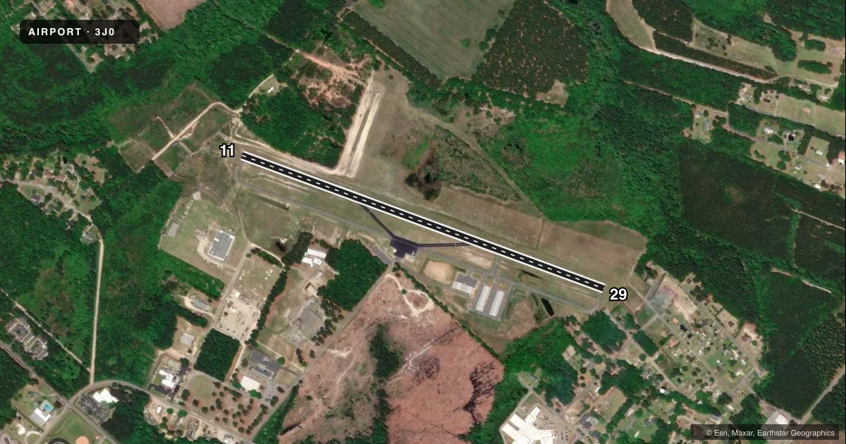
Airport sketch
Runways drawn to scale from FAA survey coordinates, rendered over satellite imagery. Not for navigation.
Approaches & charts
Services on the field
Fuel grades, oxygen, maintenance, ramp storage and lighting — as declared to the FAA by the airport operator.
Fuel & services
- Fuel
- 100LLA
- Oxygen (bottled)
- Not available
- Oxygen (bulk)
- Not available
- Airframe repair
- Not available
- Power plant repair
- Not available
Ramp & ground
- Transient storage
- Tie-down
- Landing fee
- No fee published
- Customs
- Not available
- Wind indicator
- Lighted
- Segmented circle
- No
Fuel & FBOs
Cheapest 100LL and Jet A on the field and nearby. Always confirm with the FBO before taxi.
Airport notes
Surface conditions, obstructions, local procedures, lighting outages and other notes published with each FAA cycle.
General notes
- MKD WATER TANK APRXLY 680 FT FROM RWY 29.
- FOR CD CTC JACKSONVILLE ARTCC AT 904-845-1592.
- ARPT PHONE NR 803-914-2086.
- WX ADZY AVBL: FOUR MIC CLICKS ON CTAF 122.9. ADZY ONLY, NOT FOR IFR USE.
Fuel notes
- 100LL100LL & JET A FUEL ABL 24 HRS SELF SVC WITH CREDIT CARD.
Approach & departure obstructions
- 29OFF RWY 29, A YELLOW PROPERTY POST 100 FT FM THLD AND 35 FT LEFT OF CNTRLN. ALSO A 20 FT POWER POLE 145 FT FM THLD AND 75 FT LEFT OF CNTRLN. ALSO A 23 FT TREE 131 FT FM THLD AND 66 FT LEFT OF CNTRLN.
Other notes
- ARPT EXISTED PRIOR TO 1958.
VFR map & nearby airports
VFR sectional. Tap any ICAO chip to open that airport.
Key facts · 3J0
Answer card- ICAO
- 3J0
- Name
- HAMPTON COUNTY
- Location
- HAMPTON, SOUTH CAROLINA
- Elevation
- 112.1 ft MSL
- Traffic pattern altitude
- 1,112.1 ft MSL (1,000 AGL)
- Control tower
- Non-towered (use CTAF)
- Total runways
- 1
- Longest runway
- 11/29 · 3,601 ft
- Published ILS approaches
- 0
- Published frequencies
- 1
- Magnetic variation
- 4°
- Current flight rules
- LIFR
- Current wind
- 000° at 0 kt
- Favored runway now
- –
Hampton County Airport sits in Hampton, South Carolina. The field elevation is 112.1 ft MSL. It has one runway. Runway 11/29 is 3,601 ft long with asphalt pavement. There is no control tower, so CTAF 122.9 is the main frequency for traffic and the weather advisory. The advisory service is available with four microphone clicks on CTAF 122.9. It is advisory only. Do not use it for IFR planning.
No ILS approaches are published here. Pattern altitude is not published in the facts, so use the standard 1,000 ft AGL pattern unless the current Chart Supplement says otherwise. For this field that works out to about 1,112 ft MSL based on the listed elevation. The airport has 24-hour self-serve 100LL and Jet A with credit card access. There are no on-field FBOs listed, so call the airport operator or the field directly before arrival if you need ramp or service details. The airport phone number is 803-914-2086.
Watch the runway 29 departure and arrival side closely. Published obstructions near that end include a yellow property post, a power pole, a tree and a marked water tank farther out. For IFR departures, clearance delivery is through Jacksonville ARTCC at 904-845-1592. This is a non-towered field. Expect self-announce traffic and keep an eye out for local pattern work.