METAR & TAF 99N
99N does not publish a METAR.
Showing the nearest reporting station: KBNL (BARNWELL RGNL) · 14.3 NM away. Conditions at 99N may differ.
METAR · KBNL
Observed 01:15Z
KBNL 270115Z AUTO 00000KT 10SM VCTS CLR 27/25 A2987 RMK AO2 LTG DSNT SE
- Wind
- 000° @ 0 kt
- Visibility
- 10 SM
- Temp / Dew
- 27°C / 25°C
- Altimeter
- 29.87 inHg
- Clouds
- CLR
- Density alt
- 1,788 ft
- Ceiling
- Unlimited
- Rules
- VFR
Airport info & contacts
Manager on record, flight service, ARTCC, attendance schedule and pattern altitude — published by the FAA and refreshed every 28 days.
Location
- From city
- 5 NM W
- VFR sectional
- CHARLOTTE
- ARTCC
- ZJX · JACKSONVILLE
- NOTAM facility
- AND (NOTAM-D)
Airport manager
- Name
- MR. JOEY PRESTON
- Phone
- 803-245-5191
- Address
- PO BOX 149, BAMBERG SC 29003
Flight service · Hours
- FSS AND
- ANDERSON1-800-WX-BRIEF
- Attendance
- Unattended
Frequencies
Tap any row to copy the frequency to your clipboard.
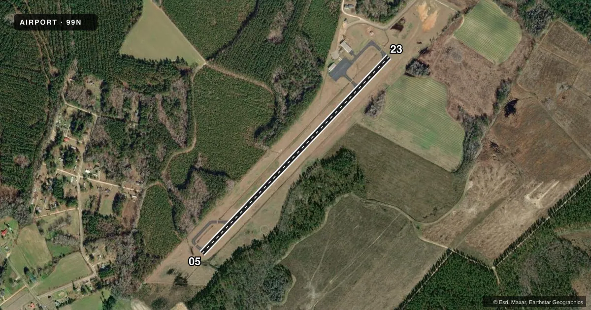
Runways & pattern
Full pagePattern entry · RWY 05
LEFT TRAFFICRunway end performance
| End | TORA | TODA | ASDA | LDA | VGSI | Approach lights | Obstruction |
|---|---|---|---|---|---|---|---|
| 05 | — | — | — | — | PAPI 2-box left(3°) | — | 78', tree, 559' from thr, 294' R of cntrln, slope 4 |
| 23 | — | — | — | — | PAPI 2-box left(3°) | — | 71', tree, 634' from thr, 309' R of cntrln, slope 6 |
Declared distances in feet. TORA = takeoff run available, TODA = takeoff distance, ASDA = accelerate-stop, LDA = landing distance.
Airport sketch
Runways drawn to scale from FAA survey coordinates, rendered over satellite imagery. Not for navigation.
Approaches & charts
Services on the field
Fuel grades, oxygen, maintenance, ramp storage and lighting — as declared to the FAA by the airport operator.
Fuel & services
- Fuel
- 100LL
- Oxygen (bottled)
- Not available
- Oxygen (bulk)
- Not available
- Airframe repair
- Not available
- Power plant repair
- Not available
- Other services
- CHTR
Ramp & ground
- Transient storage
- Tie-down
- Landing fee
- No fee published
- Lighting schedule
- SEE RMK
- Beacon schedule
- SS-SR
- Beacon
- White / Green (civil land)(WG)
- Wind indicator
- Yes
- Segmented circle
- Yes
Fuel & FBOs
Cheapest 100LL and Jet A on the field and nearby. Always confirm with the FBO before taxi.
Airport notes
Surface conditions, obstructions, local procedures, lighting outages and other notes published with each FAA cycle.
General notes
- FOR CD CTC COLUMBIA APCH AT 803-822-5242 OR 803-822-5040.
Lighting notes
- ACTVT PAPI RWY 05 & 23; MIRL RWY 05/23 - CTAF.
Other notes
- THIS AIRPORT HAS BEEN SURVEYED BY THE NATIONAL GEODETIC SURVEY.
- VFR OPNS ONLY.
- MANAGERCOUNTY ADMINISTRATOR.
VFR map & nearby airports
VFR sectional. Tap any ICAO chip to open that airport.
Key facts · 99N
Answer card- ICAO
- 99N
- Name
- BAMBERG COUNTY
- Location
- BAMBERG, SOUTH CAROLINA
- Elevation
- 231 ft MSL
- Traffic pattern altitude
- 1,231 ft MSL (1,000 AGL)
- Control tower
- Non-towered (use CTAF)
- Total runways
- 1
- Longest runway
- 05/23 · 3,603 ft
- Published ILS approaches
- 0
- Published frequencies
- 4
- Magnetic variation
- 7°
- Current flight rules
- VFR
- Current wind
- 000° at 0 kt
- Favored runway now
- –
Bamberg County Airport (99N) sits in Bamberg, South Carolina. The field elevation is 231 ft MSL. It has one runway. Runway 05/23 is 3,603 ft long with asphalt pavement. There is no control tower. Use CTAF 122.8 for local traffic. Columbia Approach handles radar and clearance support on 124.15 and 338.2. No ILS approaches are published here. Plan this field as a VFR airport only.
The pattern altitude is not published. For light piston work, use the standard 1,000 ft AGL unless the current Chart Supplement says otherwise. The runway lighting is medium intensity on 05/23. A PAPI is active on both runway ends. That helps on night or marginal VFR arrivals. The published remarks also say VFR operations only. That is the main operating limit to keep in mind.
There are no on-field FBOs listed in the facts. Contact the airport operator directly before arrival if you need services. For first-time arrivals, the key items are the single runway layout, the lack of an ILS and the need to stay on CTAF with Columbia Approach coordination as needed. Check the current Chart Supplement for any updates before you go.