METAR & TAF KOGB
Current METAR
Observed 22:53Z
KOGB 262253Z AUTO 00000KT 10SM FEW050 27/24 A2986 RMK AO2 SLP108 T02720244
- Wind
- 000° @ 0 kt
- Visibility
- 10 SM
- Temp / Dew
- 27°C / 24°C
- Altimeter
- 29.86 inHg
- Clouds
- FEW
- Density alt
- 1,757 ft
- Ceiling
- Unlimited
- Rules
- VFR
Airport info & contacts
Manager on record, flight service, ARTCC, attendance schedule and pattern altitude — published by the FAA and refreshed every 28 days.
Location
- From city
- 2 NM S
- VFR sectional
- CHARLOTTE
- ARTCC
- ZJX · JACKSONVILLE
- NOTAM facility
- OGB (NOTAM-D)
Airport manager
- Name
- BETTY BAKER
- Phone
- 803-928-1545
- Address
- 1811 AIRPORT ROAD, ORANGEBURG SC 29115
Flight service · Hours
- FSS AND
- ANDERSON1-800-WX-BRIEF
- Attendance
- MON-FRI · 0700-1700
Frequencies
Tap any row to copy the frequency to your clipboard.
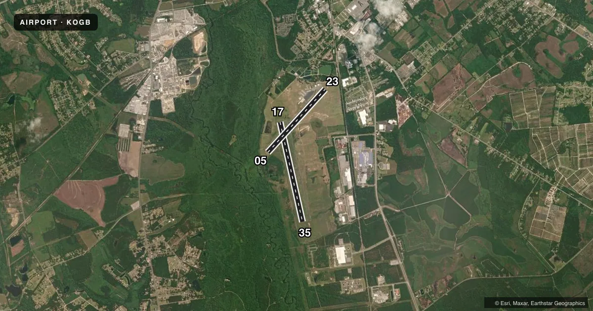
Runways & pattern
Full pagePattern entry · RWY 17
LEFT TRAFFIC| Runway | Heading (°M) | Length | Surface | Traffic |
|---|---|---|---|---|
| 17/35 | 160° / 340° | 5,399 ft | ASPH | Standard L |
| 05/23 | 35° / 215° | 4,508 ft | ASPH | 05 R |
Runway end performance
| End | TORA | TODA | ASDA | LDA | VGSI | Approach lights | Obstruction |
|---|---|---|---|---|---|---|---|
| 17 | — | — | — | — | PAPI 2-box left(3°) | ODALS | 76', tree, 2449' from thr, 128' R of cntrln, slope 29 |
| 35 | — | — | — | — | PAPI 2-box left(3°) | ODALS | — |
| 05 | — | — | — | — | VASI 4-box left(3°) | — | 32', tree, 425' from thr, 141' R of cntrln, slope 7 |
| 23 | — | — | — | — | — | — | 75', tree, 1045' from thr, 354' R of cntrln, slope 11 |
Declared distances in feet. TORA = takeoff run available, TODA = takeoff distance, ASDA = accelerate-stop, LDA = landing distance.
Airport sketch
Runways drawn to scale from FAA survey coordinates, rendered over satellite imagery. Not for navigation.
Approaches & charts
Services on the field
Fuel grades, oxygen, maintenance, ramp storage and lighting — as declared to the FAA by the airport operator.
Fuel & services
- Fuel
- 100LLA
- Oxygen (bottled)
- Not available
- Oxygen (bulk)
- Not available
- Airframe repair
- Minor
- Power plant repair
- Minor
- Other services
- AVNCS,INSTR
Ramp & ground
- Transient storage
- Tie-down
- Landing fee
- No fee published
- Customs
- Not available
- Lighting schedule
- SEE RMK
- Beacon schedule
- SS-SR
- Beacon
- White / Green (civil land)(WG)
- Wind indicator
- Lighted
- Segmented circle
- Yes
Fuel & FBOs
Cheapest 100LL and Jet A on the field and nearby. Always confirm with the FBO before taxi.
Airport notes
Surface conditions, obstructions, local procedures, lighting outages and other notes published with each FAA cycle.
General notes
- RWY 05 HAS MKD PLINES 1000 FT FROM THLD.
- GCO AVBL ON FREQ 125.675 MONITORED BY COLUMBIA APCH CTL.
- FOR CD IF UNA VIA GCO CTC JACKSONVILLE ARTCC AT 904-845-1592.
Lighting notes
- ACTVT ODALS RWY 17/35, REIL RWY 23 & RWY 17/35; MIRL RWY 05/23 & RWY 17/35 - CTAF. PAPI RWY 17 & 35 OPER CONSLY.
Approach & departure obstructions
- 05RWY 05 VASI OTS INDEFLY.
Other notes
- EXISTED PRIOR TO 1958.
- 1NOT MANNED ON SAT OR SUN - FOR ASST PHONE AMGR.
VFR map & nearby airports
VFR sectional. Tap any ICAO chip to open that airport.
Key facts · KOGB
Answer card- ICAO
- KOGB
- Name
- ORANGEBURG MUNI
- Location
- ORANGEBURG, SOUTH CAROLINA
- Elevation
- 195.4 ft MSL
- Traffic pattern altitude
- 1,195.4 ft MSL (1,000 AGL)
- Control tower
- Non-towered (use CTAF)
- Total runways
- 2
- Longest runway
- 17/35 · 5,399 ft
- Published ILS approaches
- 0
- Published frequencies
- 4
- Magnetic variation
- 7°
- Current flight rules
- VFR
- Current wind
- 000° at 0 kt
- Favored runway now
- –
Orangeburg Muni is in Orangeburg, South Carolina. The field elevation is 195.4 ft MSL. It has two asphalt runways. The longest is 17/35 at 5,399 ft. There is no control tower. CTAF and UNICOM are both 122.7. Columbia Approach handles the published approach and departure frequencies.
No ILS approaches are published here. Pattern altitude is not published in the facts, so use the standard 1,000 ft AGL for light piston traffic unless the current Chart Supplement says otherwise. The on-field FBO is Orangeburg Municipal Airport. It carries 100LL, Jet A and Jet A Prist. Call (803) 534-5545 for current service details.
A few operational notes matter here. The VASI for runway 05 is out of service indefinitely. Runway 17 and 35 have continuous PAPI operation. The airport also has runway end identifier lights on 23 and 17/35. Runway 05 has marked pilot lines 1,000 ft from the threshold. The airport is not manned on Saturday or Sunday. If you need help, call the airport manager. For clearance delivery, use the ground communications outlet on 125.675 when available. If that does not work, Jacksonville ARTCC can help with clearance delivery. This is a non-towered field. Expect self-announce traffic. Keep a close eye on pattern work.