METAR & TAF KCUB
Current METAR
Observed 04:53Z
KCUB 270453Z AUTO 00000KT 10SM CLR 26/24 A2991 RMK AO2 SLP124 T02560244 403280239
- Wind
- 000° @ 0 kt
- Visibility
- 10 SM
- Temp / Dew
- 26°C / 24°C
- Altimeter
- 29.91 inHg
- Clouds
- CLR
- Density alt
- 1,572 ft
- Ceiling
- Unlimited
- Rules
- VFR
Airport info & contacts
Manager on record, flight service, ARTCC, attendance schedule and pattern altitude — published by the FAA and refreshed every 28 days.
Location
- From city
- 2 NM S
- VFR sectional
- CHARLOTTE
- Pattern altitude
- 807 ft AGL · 1,000 ft MSL
- ARTCC
- ZJX · JACKSONVILLE
- NOTAM facility
- CUB (NOTAM-D)
Airport manager
- Name
- PETER CEVALLOS
- Phone
- 803-771-7915
- Address
- 1400 JIM HAMILTON BLVD, COLUMBIA SC 29205
Flight service · Hours
- FSS AND
- ANDERSON1-800-WX-BRIEF
- Attendance
- 0600-2200
Frequencies
Tap any row to copy the frequency to your clipboard.
Runways & pattern
Full pagePattern entry · RWY 13
RIGHT TRAFFICRunway end performance
| End | TORA | TODA | ASDA | LDA | VGSI | Approach lights | Obstruction |
|---|---|---|---|---|---|---|---|
| 13 | 4,999' | 4,999' | 4,999' | 4,999' | PAPI 2-box left(4°) | — | 77', tree, 1096' from thr, 148' R of cntrln, slope 11 |
| 31 | 4,999' | 4,999' | 4,999' | 4,599' | PAPI 2-box right(3°) | — | 64', tree, 1053' from thr, 353' R of cntrln, slope 13 |
Declared distances in feet. TORA = takeoff run available, TODA = takeoff distance, ASDA = accelerate-stop, LDA = landing distance.
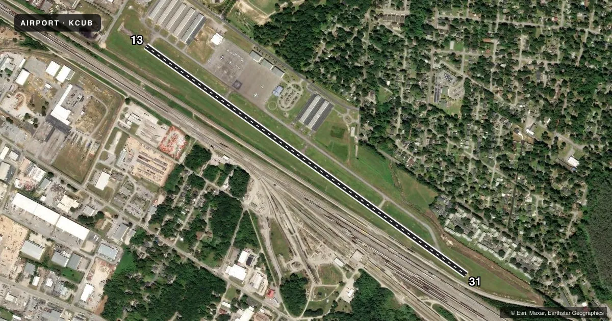
Airport sketch
Runways drawn to scale from FAA survey coordinates, rendered over satellite imagery. Not for navigation.
Approaches & charts
ILS · 1
Services on the field
Fuel grades, oxygen, maintenance, ramp storage and lighting — as declared to the FAA by the airport operator.
Fuel & services
- Fuel
- 100LLA
- Oxygen (bulk)
- HIGH/LOW
- Airframe repair
- Major
- Power plant repair
- Major
- Other services
- AVNCS,CHTR,INSTR,RNTL
Ramp & ground
- Transient storage
- Tie-down
- Hangar
- Landing fee
- No fee published
- Customs
- Not available
- Lighting schedule
- SEE RMK
- Beacon schedule
- SS-SR
- Beacon
- White / Green (civil land)(WG)
- Wind indicator
- Lighted
- Segmented circle
- Yes
Fuel & FBOs
Cheapest 100LL and Jet A on the field and nearby. Always confirm with the FBO before taxi.
Airport notes
Surface conditions, obstructions, local procedures, lighting outages and other notes published with each FAA cycle.
General notes
- RR SWITCHING YARD PARALLEL TO RY 13/31.
- AVOID NOISE SENSITIVE AREA NORTH OF ARPT BLO 1500 FT.
- NO NORTHBOUND DEP TURNS EITHER RY BLO 1500 FT.
- RY TO TWY SEPARATION IS 206 FT. THE SEPARATION DESIGN CRITERION IS NOT FULLY MET FOR ACFT 12,500 LBS AND LARGER
- DUE TO PROXIMITY AND RY ALIGNMENT, AIRCREWS HAVE MISTAKEN CAE (RY 11/29) FOR CUB (RY 13/31) WHICH IS 6 MILES SW.
- FOR CD CTC COLUMBIA APCH AT 803-822-5242 OR 803-822-5040.
Lighting notes
- ACTVT MIRL RY 13/31 AND REILS RYS 13 & 31 - CTAF.
Fuel notes
- 100LLCONTRACT FUEL FOR MILITARY.
Approach & departure obstructions
- 31RY 31, 18 FTTREES, 160 FT FM THLD 56 FT LEFT OF CENTERLINE.
- 13400 FT STWY NW END OF RY.
- 13PAPI RWY 13 UNUSBL BYD 8 DEG RT.
- 13RY 13 71 FT TREE 148 FT LEFT OF CNTRLN & 1096 FT FROM THLD, 40 FT POWER LINES 180 FT RIGHT OF CNTRLN & 958 FT FROM THLD, 30 FT BLDG 140 FT RIGHT & 900 FT FM THLD, 27 FT BLDG 653 FT FROM THLD & 172 FT LEFT.
Other notes
- EXISTED PRIOR TO 1958.
- TPA: 807 FT AGL / 1000 FT MSL.
- 1FOR SERVICE AFTER HRS CALL 803-771-7915.
- MANAGERFBO EAGLE AVIATION 803-771-7915.
VFR map & nearby airports
VFR sectional. Tap any ICAO chip to open that airport.
Key facts · KCUB
Answer card- ICAO
- KCUB
- Name
- JIM HAMILTON L B OWENS
- Location
- COLUMBIA, SOUTH CAROLINA
- Elevation
- 193.4 ft MSL
- Traffic pattern altitude
- 1,000.4 ft MSL (807 AGL)
- Control tower
- Non-towered (use CTAF)
- Total runways
- 1
- Longest runway
- 13/31 · 5,011 ft
- Published ILS approaches
- 1
- Published frequencies
- 5
- Magnetic variation
- 6°
- Current flight rules
- VFR
- Current wind
- 000° at 0 kt
- Favored runway now
- –
JIM HAMILTON L B OWENS is in Columbia, South Carolina. The field elevation is 193.4 ft MSL. It has one runway, 13/31, which is 5,011 ft long. There is no control tower. Pattern altitude is 807 ft AGL, which is 1,000.4 ft MSL.
Runway 31 has the published ILS approach. Medium intensity runway lights are activated on runway 13/31 via CTAF. Eagle Aviation is on the field. It carries 100LL, Jet A and Jet A Prist. For service after hours, call the FBO directly at 803-771-7915.
First-time pilots should pay close attention to the published remarks. Noise sensitive areas are north of the airport below 1,500 ft. Runway 13 has several obstacles near the approach path, including trees, power lines and buildings. There is also a railroad switching yard parallel to the runway. The Chart Supplement notes that runway 13/31 has a runway to taxiway separation issue for aircraft 12,500 lb and larger. Crews have also mistaken nearby CAE runway 11/29 for CUB runway 13/31. Verify your position before joining the pattern or starting an approach.