METAR & TAF KSMS
Current METAR
Observed 06:15Z
KSMS 270615Z AUTO 00000KT 9SM CLR 23/23 A2988 RMK AO2
- Wind
- 000° @ 0 kt
- Visibility
- 9 SM
- Temp / Dew
- 23°C / 23°C
- Altimeter
- 29.88 inHg
- Clouds
- CLR
- Density alt
- 1,235 ft
- Ceiling
- Unlimited
- Rules
- VFR
Airport info & contacts
Manager on record, flight service, ARTCC, attendance schedule and pattern altitude — published by the FAA and refreshed every 28 days.
Location
- From city
- 4 NM N
- VFR sectional
- CHARLOTTE
- ARTCC
- ZJX · JACKSONVILLE
- NOTAM facility
- AND (NOTAM-D)
Airport manager
- Name
- JEFF KNAUER
- Phone
- 803-469-4639
- Address
- 2945 AIRPORT ROAD, SUMTER SC 29153
Flight service · Hours
- FSS AND
- ANDERSON1-800-WX-BRIEF
- Attendance
- 0800-1800
Frequencies
Tap any row to copy the frequency to your clipboard.
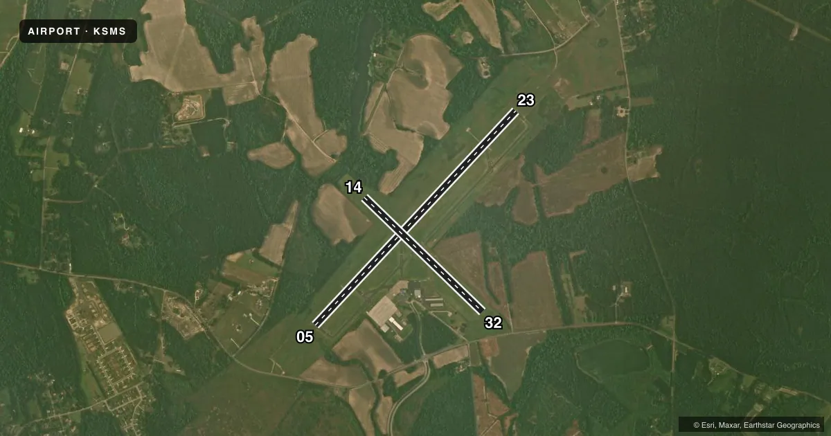
Runways & pattern
Full pagePattern entry · RWY 05
RIGHT TRAFFIC| Runway | Heading (°M) | Length | Surface | Traffic |
|---|---|---|---|---|
| 05/23 | 36° / 216° | 5,501 ft | ASPH | 05 R |
| 14/32 | 127° / 307° | 3,081 ft | TURF | 32 R |
Runway end performance
| End | TORA | TODA | ASDA | LDA | VGSI | Approach lights | Obstruction |
|---|---|---|---|---|---|---|---|
| 05 | — | — | — | — | PAPI 4-box left(3°) | — | 79', trees, 2373' from thr, 565' R of cntrln, slope 27 |
| 23 | — | — | — | — | PAPI 4-box left(3°) | ODALS | 88', trees, 2748' from thr, 659' R of cntrln, slope 28 |
| 14 | — | — | — | — | — | — | 84', trees, 941' from thr, 152' R of cntrln, slope 8 |
| 32 | — | — | — | — | — | — | 95', tree, 1369' from thr, 113' R of cntrln, slope 14 |
Declared distances in feet. TORA = takeoff run available, TODA = takeoff distance, ASDA = accelerate-stop, LDA = landing distance.
Airport sketch
Runways drawn to scale from FAA survey coordinates, rendered over satellite imagery. Not for navigation.
Approaches & charts
ILS · 1
Services on the field
Fuel grades, oxygen, maintenance, ramp storage and lighting — as declared to the FAA by the airport operator.
Fuel & services
- Fuel
- 100LLA
- Oxygen (bottled)
- Not available
- Oxygen (bulk)
- Not available
- Airframe repair
- Major
- Power plant repair
- Major
- Other services
- AVNCS,INSTR,RNTL
Ramp & ground
- Transient storage
- Tie-down
- Hangar
- Landing fee
- No fee published
- Customs
- Not available
- Lighting schedule
- SEE RMK
- Beacon schedule
- SS-SR
- Beacon
- White / Green (civil land)(WG)
- Wind indicator
- Lighted
- Segmented circle
- Yes
Fuel & FBOs
Cheapest 100LL and Jet A on the field and nearby. Always confirm with the FBO before taxi.
Airport notes
Surface conditions, obstructions, local procedures, lighting outages and other notes published with each FAA cycle.
General notes
- WILDLIFE ON & INVOF ARPT WITH INCR ACTVTY DUSK & DAWN.
- FOR CD CTC SHAW APCH AT 803-895-4884, WHEN APCH CLSD CTC JACKSONVILLE ARTCC AT 904-845-1592.
- FOR 100LL AFT 1700 CALL 803-469-4639.
Lighting notes
- AFT 2000, ACTVT REILS RWY 05/23; MIRL RWY 05/23 - CTAF. PAPI RWY 05 & 23 OPER CONSLY.
VFR map & nearby airports
VFR sectional. Tap any ICAO chip to open that airport.
Key facts · KSMS
Answer card- ICAO
- KSMS
- Name
- SUMTER
- Location
- SUMTER, SOUTH CAROLINA
- Elevation
- 182.1 ft MSL
- Traffic pattern altitude
- 1,182.1 ft MSL (1,000 AGL)
- Control tower
- Non-towered (use CTAF)
- Total runways
- 2
- Longest runway
- 05/23 · 5,501 ft
- Published ILS approaches
- 1
- Published frequencies
- 3
- Magnetic variation
- 7°
- Current flight rules
- VFR
- Current wind
- 000° at 0 kt
- Favored runway now
- –
KSMS is in Sumter, South Carolina. The field elevation is 182.1 ft MSL. It has two runways. The longest is 5,501 ft asphalt runway 05/23. The other runway is 3,081 ft turf runway 14/32. This is an untowered field. Plan to self-announce on CTAF 122.7 and work the pattern with local traffic in mind.
The published pattern altitude is not listed. Use the standard 1,000 ft AGL pattern unless local procedures or ATC say otherwise. Runway 23 has an ILS approach. That is the only published ILS here. The airport sits in the Shaw approach area, so clearance delivery goes through Shaw Approach when it is open. When it is closed, use Jacksonville ARTCC. The on-field FBO is On Eagles' Wings. It carries 100LL and Jet A Prist. For 100LL after 1700, call the FBO first.
A few operational details matter here. After 2000, runway end identifier lights on 05/23 and the medium intensity runway lights on 05/23 are activated via CTAF. The precision approach path indicators on 05 and 23 run continuously. Wildlife is reported on and near the airport. Activity is higher at dusk and dawn. If you are new to KSMS, brief the lighting. Watch for wildlife. Expect a straightforward but active local environment.