METAR & TAF KCDN
Current METAR
Observed 03:55Z
KCDN 270355Z AUTO 00000KT 10SM CLR 25/25 A2992 RMK AO2
- Wind
- 000° @ 0 kt
- Visibility
- 10 SM
- Temp / Dew
- 25°C / 25°C
- Altimeter
- 29.92 inHg
- Clouds
- CLR
- Density alt
- 1,575 ft
- Ceiling
- Unlimited
- Rules
- VFR
Airport info & contacts
Manager on record, flight service, ARTCC, attendance schedule and pattern altitude — published by the FAA and refreshed every 28 days.
Location
- From city
- 3 NM NE
- VFR sectional
- CHARLOTTE
- ARTCC
- ZJX · JACKSONVILLE
- NOTAM facility
- AND (NOTAM-D)
Airport manager
- Name
- MR. GERALD BLANCHARD
- Phone
- 803-729-0925
- Address
- 2203 AIRLINE DRIVE, CAMDEN SC 29020
Flight service · Hours
- FSS AND
- ANDERSON1-800-WX-BRIEF
- Attendance
- MON-FRI · 0800-1800
- SAT-SUN · 0800-1700
Frequencies
Tap any row to copy the frequency to your clipboard.
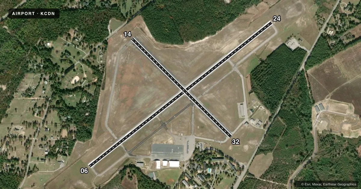
Runways & pattern
Full pagePattern entry · RWY 06
LEFT TRAFFIC| Runway | Heading (°M) | Length | Surface | Traffic |
|---|---|---|---|---|
| 06/24 | 47° / 227° | 5,000 ft | ASPH | Standard L |
| 14/32 | 130° / 310° | 2,998 ft | ASPH | Standard L |
Runway end performance
| End | TORA | TODA | ASDA | LDA | VGSI | Approach lights | Obstruction |
|---|---|---|---|---|---|---|---|
| 06 | — | — | — | — | PAPI 2-box left(3°) | — | — |
| 24 | — | — | — | — | PAPI 2-box left(3°) | — | 27', pole, 1024' from thr, 153' R of cntrln, slope 30 |
| 14 | — | — | — | — | — | — | 56', tree, 541' from thr, 227' R of cntrln, slope 6 |
| 32 | — | — | — | — | — | — | 31', tree, 653' from thr, 90' R of cntrln, slope 14 |
Declared distances in feet. TORA = takeoff run available, TODA = takeoff distance, ASDA = accelerate-stop, LDA = landing distance.
Airport sketch
Runways drawn to scale from FAA survey coordinates, rendered over satellite imagery. Not for navigation.
Approaches & charts
Services on the field
Fuel grades, oxygen, maintenance, ramp storage and lighting — as declared to the FAA by the airport operator.
Fuel & services
- Fuel
- 100LLA
- Oxygen (bottled)
- Low pressure
- Oxygen (bulk)
- Not available
- Airframe repair
- Major
- Power plant repair
- Major
- Other services
- INSTR,RNTL
Ramp & ground
- Transient storage
- Tie-down
- Hangar
- Landing fee
- No fee published
- Customs
- Not available
- Lighting schedule
- SEE RMK
- Beacon schedule
- SS-SR
- Beacon
- White / Green (civil land)(WG)
- Wind indicator
- Lighted
- Segmented circle
- Yes
Fuel & FBOs
Cheapest 100LL and Jet A on the field and nearby. Always confirm with the FBO before taxi.
Airport notes
Surface conditions, obstructions, local procedures, lighting outages and other notes published with each FAA cycle.
General notes
- FOR CD CTC JACKSONVILLE ARTCC AT 904-845-1592.
Lighting notes
- DUSK-DAWN. MIRL RWY 06/24 PRESET LOW INTST; TO INCR INTST AND ACTVT REIL RWY 06 & 24; PAPI RWY 06 & 24 - CTAF.
Other notes
- EXISTED PRIOR TO 1958.
- 1FOR AFT HRS SVC CALL 803-713-4655.
VFR map & nearby airports
VFR sectional. Tap any ICAO chip to open that airport.
Key facts · KCDN
Answer card- ICAO
- KCDN
- Name
- WOODWARD FLD
- Location
- CAMDEN, SOUTH CAROLINA
- Elevation
- 302.5 ft MSL
- Traffic pattern altitude
- 1,302.5 ft MSL (1,000 AGL)
- Control tower
- Non-towered (use CTAF)
- Total runways
- 2
- Longest runway
- 06/24 · 5,000 ft
- Published ILS approaches
- 0
- Published frequencies
- 4
- Magnetic variation
- 5°
- Current flight rules
- VFR
- Current wind
- 000° at 0 kt
- Favored runway now
- –
Woodward Fld sits in Camden, South Carolina. Field elevation is 302.5 ft MSL. The airport has two asphalt runways. The longest is 5,000 ft on 06/24. There is no control tower. Pattern altitude is not published. Use 1,000 ft AGL for light piston traffic unless the current Chart Supplement says otherwise.
No ILS approaches are published here. Runway 06/24 has lighting from dusk to dawn. The medium intensity lights on 06/24 start at low intensity. Use the CTAF to raise intensity and to turn on the runway end identifier lights. Precision approach path indicators are available on 06 and 24. Those are also activated via CTAF. That makes the field workable after dark, but you still need to verify current procedures before you go.
Kershaw County FBO is on the field. It carries 100LL and Jet A Prist. For after-hours service, the published number is available in the Chart Supplement remarks. The airport also notes that clearance delivery is handled through Jacksonville ARTCC. This is a non-towered field with two published approach frequencies tied to Shaw. Check the current Chart Supplement for any local procedures, then plan your arrival with the runway lighting and CTAF use in mind.