METAR & TAF KPYG
KPYG does not publish a METAR.
Showing the nearest reporting station: KCQW (CHERAW MUNI/LYNCH BELLINGER FLD) · 19.2 NM away. Conditions at KPYG may differ.
METAR · KCQW
Observed 13:35Z
KCQW 251335Z AUTO 35004KT 10SM FEW038 24/23 A3007 RMK AO2 LTG DSNT SE AND S
- Wind
- 350° @ 4 kt
- Visibility
- 10 SM
- Temp / Dew
- 24°C / 23°C
- Altimeter
- 30.07 inHg
- Clouds
- FEW
- Density alt
- 1,607 ft
- Ceiling
- Unlimited
- Rules
- VFR
Airport info & contacts
Manager on record, flight service, ARTCC, attendance schedule and pattern altitude — published by the FAA and refreshed every 28 days.
Location
- From city
- 3 NM SE
- VFR sectional
- CHARLOTTE
- ARTCC
- ZTL · ATLANTA
- NOTAM facility
- AND (NOTAM-D)
Airport manager
- Name
- SHANE SLIGH
- Phone
- 843-672-7292
- Address
- 307 E MCGREGOR STREET, 126 N PEARL ST, PAGELAND SC 29728-1951
Flight service · Hours
- FSS AND
- ANDERSON1-800-WX-BRIEF
- Attendance
- Unattended
Frequencies
Tap any row to copy the frequency to your clipboard.
Runways & pattern
Full pagePattern entry · RWY 06
LEFT TRAFFICRunway end performance
| End | TORA | TODA | ASDA | LDA | VGSI | Approach lights | Obstruction |
|---|---|---|---|---|---|---|---|
| 06 | — | — | — | — | PAPI 2-box left(3°) | — | — |
| 24 | — | — | — | — | PAPI 2-box left(3°) | — | 27', pole, 181' from thr, 186' R of cntrln, slope 0 |
Declared distances in feet. TORA = takeoff run available, TODA = takeoff distance, ASDA = accelerate-stop, LDA = landing distance.
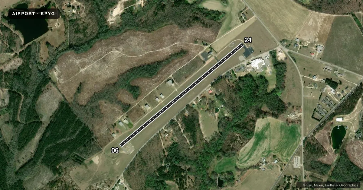
Airport sketch
Runways drawn to scale from FAA survey coordinates, rendered over satellite imagery. Not for navigation.
Approaches & charts
Services on the field
Fuel grades, oxygen, maintenance, ramp storage and lighting — as declared to the FAA by the airport operator.
Fuel & services
- Fuel
- 100LL
- Oxygen (bottled)
- Not available
- Oxygen (bulk)
- Not available
- Airframe repair
- Not available
- Power plant repair
- Not available
Ramp & ground
- Transient storage
- Tie-down
- Landing fee
- No fee published
- Customs
- Not available
- Lighting schedule
- SEE RMK
- Beacon schedule
- SS-SR
- Beacon
- White / Green (civil land)(WG)
- Wind indicator
- Lighted
- Segmented circle
- Yes
Fuel & FBOs
Cheapest 100LL and Jet A on the field and nearby. Always confirm with the FBO before taxi.
Airport notes
Surface conditions, obstructions, local procedures, lighting outages and other notes published with each FAA cycle.
General notes
- FOR CD CTC CHARLOTTE APCH AT 704-359-0241.
Lighting notes
- ACTVT PAPI RWY 6 & 24 - CTAF.
Fuel notes
- 100LLSELF SVC FUEL AVBL 24 HRS.
Approach & departure obstructions
- 2431 FT PWR POLE 182 FT FM RWY END, 188 FT R OF CNTRLN. ACCESS ROAD 27 FEET FROM RWY END.
- 06CONTROLLING OBSTRUCTION EXCEEDS A 45 DEGREE SLOPE
VFR map & nearby airports
VFR sectional. Tap any ICAO chip to open that airport.
Key facts · KPYG
Answer card- ICAO
- KPYG
- Name
- PAGELAND
- Location
- PAGELAND, SOUTH CAROLINA
- Elevation
- 574.9 ft MSL
- Traffic pattern altitude
- 1,574.9 ft MSL (1,000 AGL)
- Control tower
- Non-towered (use CTAF)
- Total runways
- 1
- Longest runway
- 06/24 · 3,396 ft
- Published ILS approaches
- 0
- Published frequencies
- 3
- Magnetic variation
- 8°
- Current flight rules
- VFR
- Current wind
- 350° at 4 kt
- Favored runway now
- RWY 06
Pageland Airport is in Pageland, South Carolina. Field elevation is 574.9 ft MSL. The airport has one runway. Runway 06/24 is 3,396 ft long with an asphalt surface. There is no control tower. CTAF is 122.9. The published pattern altitude is not listed, so use 1,000 ft AGL for light piston operations unless the current Chart Supplement says otherwise.
No ILS approaches are published here. For clearance delivery, Charlotte Approach can be reached at 704-359-0241. The field uses Charlotte Approach frequencies on 120.05 and 307.8 for approach and departure services. The on-field FBO is Pageland Airport. It carries self-serve 100LL. Fuel is available 24 hours. The PAPI on runways 06 and 24 is activated by the CTAF, so make sure you know the local activation procedure before you get close.
First-time pilots should pay attention to the runway end conditions. The Chart Supplement notes a controlling obstruction near runway 06 that exceeds a 45 degree slope. Near runway 24, there is a 31-foot power pole close to the departure end plus an access road near the runway end. Review the current Chart Supplement before arrival and plan your approach and departure with those items in mind.