METAR & TAF N52
N52 does not publish a METAR.
Showing the nearest reporting station: KLKR (LANCASTER COUNTY-MC WHIRTER FLD) · 10.0 NM away. Conditions at N52 may differ.
METAR · KLKR
Observed 02:35Z
KLKR 270235Z AUTO 00000KT 10SM CLR 25/24 A2991 RMK AO2
- Wind
- 000° @ 0 kt
- Visibility
- 10 SM
- Temp / Dew
- 25°C / 24°C
- Altimeter
- 29.91 inHg
- Clouds
- CLR
- Density alt
- 1,959 ft
- Ceiling
- Unlimited
- Rules
- VFR
Airport info & contacts
Manager on record, flight service, ARTCC, attendance schedule and pattern altitude — published by the FAA and refreshed every 28 days.
Location
- From city
- 3 NM S
- VFR sectional
- CHARLOTTE
- ARTCC
- ZTL · ATLANTA
- NOTAM facility
- RDU (NOTAM-D)
Airport manager
- Name
- DAN MILLER
- Phone
- 704-843-6220
- Address
- 7710 JAARS ROAD, WAXHAW NC 28173
Flight service · Hours
- FSS RDU
- RALEIGH1-800-WX-BRIEF
- Attendance
- MON-FRI · 0800-1700
Frequencies
Tap any row to copy the frequency to your clipboard.
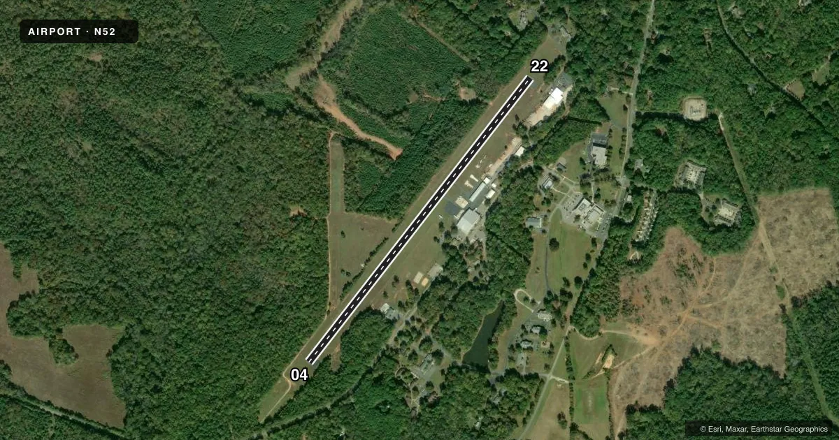
Runways & pattern
Full pagePattern entry · RWY 04
LEFT TRAFFICRunway end performance
| End | TORA | TODA | ASDA | LDA | VGSI | Approach lights | Obstruction |
|---|---|---|---|---|---|---|---|
| 04 | — | — | — | — | — | — | 50', trees, 342' from thr, 63' R of cntrln, slope 2 |
| 22 | — | — | — | — | — | — | 59', trees, 301' from thr, 148' R of cntrln, slope 1 |
Declared distances in feet. TORA = takeoff run available, TODA = takeoff distance, ASDA = accelerate-stop, LDA = landing distance.
Airport sketch
Runways drawn to scale from FAA survey coordinates, rendered over satellite imagery. Not for navigation.
Approaches & charts
Services on the field
Fuel grades, oxygen, maintenance, ramp storage and lighting — as declared to the FAA by the airport operator.
Fuel & services
- Fuel
- Not available
- Oxygen (bottled)
- Not available
- Oxygen (bulk)
- Not available
- Other services
- AVNCS
Ramp & ground
- Transient storage
- Tie-down
- Landing fee
- No fee published
- Lighting schedule
- SEE RMK
- Beacon schedule
- SEE RMK
- Beacon
- White / Green (civil land)(WG)
- Wind indicator
- Lighted
- Segmented circle
- No
Fuel & FBOs
Cheapest 100LL and Jet A on the field and nearby. Always confirm with the FBO before taxi.
Airport notes
Surface conditions, obstructions, local procedures, lighting outages and other notes published with each FAA cycle.
General notes
- RWY 04 HAS 5 FT DROP-OFF 150 FT FM THR, 0 BOTH.
- DEER ON AND INVOF ARPT.
- RWY 04/22 20 FT DOWN SLOPE BTN ENDS.
- SFC VARN IN RESA.
- WIND CONDS PMTG AT NIGHT TKOF RWY 22 & LAND RWY 04.
- TSNT TFC PROHIBITED FM LNDG ON GRASS PRACTICE AREAS.
- FOR CD CTC CHARLOTTE APCH AT 704-359-0241.
- TSNT TFC NOTE THAT ONLY JAARS PILOTS ARE PMTD TO USE NON-STD PATTERNS FOR T.
Lighting notes
- ACTVT BEACON - CTAF.
- ACTVT LIRL RWY 04/22 - CTAF.
Runway surface & condition
- 04/22RWY 04/22 NSTD LIRL. ONLY THREE END LGTS EACH SIDE OF RWYS & EACH SIDE OF DSPLCD THR.
Approach & departure obstructions
- 04+15 FT WINDSOCK POLE 132 FT FROM THR OFFSET 74 FT LEFT OF CNTRLN; AND +51 FT TREES 0-200 FT FROM THR OFFSET 133 FT RIGHT OF CNTRLN; +51 FT TREES 0-200 FT FROM THR OFFSET 157 FT LEFT OF CNTRLN; AND +7 FT FENCE 0-200 FT FROM THR OFFSET 112 FT RIGHT AND OFFSET 120 FT LEFT OF CNTRLN.
- 2284 FT TREES 0-200 FT FM THR OFFSET 133 FT RIGHT; 65 FT TREES 0-200 FT FM THR OFFSET 107 FT LEFT.
- 04MRKGS SMALLER THAN STD DUE TO PVMT WIDTH.
- 22MRKGS SMALLER THAN STD DUE TO PVMT WIDTH.
- 22APCH SLOPE 5:1 TO DSPLCD THR.
Other notes
- 1UNATNDD MAJOR HOLS.
VFR map & nearby airports
VFR sectional. Tap any ICAO chip to open that airport.
Key facts · N52
Answer card- ICAO
- N52
- Name
- JAARS-TOWNSEND
- Location
- WAXHAW, NORTH CAROLINA
- Elevation
- 602 ft MSL
- Traffic pattern altitude
- 1,602 ft MSL (1,000 AGL)
- Control tower
- Non-towered (use CTAF)
- Total runways
- 1
- Longest runway
- 04/22 · 3,309 ft
- Published ILS approaches
- 0
- Published frequencies
- 4
- Magnetic variation
- 7°
- Current flight rules
- VFR
- Current wind
- 000° at 0 kt
- Favored runway now
- –
JAARS-TOWNSEND is in Waxhaw, North Carolina. The field elevation is 602 ft MSL. It has one runway. Runway 04/22 is 3,309 ft long with asphalt pavement. There is no control tower. CTAF and UNICOM are both 123.0. No ILS approaches are published here.
Pattern altitude is not published. Use the standard 1,000 ft AGL pattern for light piston traffic unless the current Chart Supplement or the airport operator gives you different guidance. The airport sits in the Charlotte area, so expect to work with Charlotte Approach for clearance delivery. The published remarks also note that transient traffic is not allowed to use the grass practice areas. Only JAARS pilots are permitted to use non-standard patterns for training.
Runway 04/22 has low intensity lighting that is activated by CTAF. The runway also has a 20 ft downslope between the ends. Published remarks call out trees and fence obstructions near both ends. Deer are also reported on and near the airport. There are no on-field FBOs listed, so contact the airport operator directly or call the field on CTAF or UNICOM for current service details before you go.