METAR & TAF KUZA
Current METAR
Observed 07:40Z
KUZA 270740Z AUTO 22003KT 2SM BR FEW003 23/23 A2987 RMK AO2 T02280228
- Wind
- 220° @ 3 kt
- Visibility
- 2 SM
- Temp / Dew
- 23°C / 23°C
- Altimeter
- 29.87 inHg
- Clouds
- FEW
- Density alt
- 1,848 ft
- Ceiling
- Unlimited
- Rules
- IFR
Airport info & contacts
Manager on record, flight service, ARTCC, attendance schedule and pattern altitude — published by the FAA and refreshed every 28 days.
Location
- From city
- 4 NM NW
- VFR sectional
- CHARLOTTE
- ARTCC
- ZTL · ATLANTA
- NOTAM facility
- UZA (NOTAM-D)
Airport manager
- Name
- STEVEN A. GOULD JR., C.M.
- Phone
- 803-329-5560
- Address
- 550 AIRPORT RD, SUITE 205, ROCK HILL SC 29732
Flight service · Hours
- FSS AND
- ANDERSON1-800-WX-BRIEF
- Attendance
- MON-FRI · 0700-2000
- SAT-SUN · 0800-1900
Frequencies
Tap any row to copy the frequency to your clipboard.
Runways & pattern
Full pagePattern entry · RWY 20
LEFT TRAFFICRunway end performance
| End | TORA | TODA | ASDA | LDA | VGSI | Approach lights | Obstruction |
|---|---|---|---|---|---|---|---|
| 02 | — | — | — | — | PAPI 2-box left(3°) | MALSR | 82', tree, 1589' from thr, 725' R of cntrln, slope 16 |
| 20 | — | — | — | — | PAPI 2-box left(3°) | — | 87', tree, 1825' from thr, 523' R of cntrln, slope 18 |
Declared distances in feet. TORA = takeoff run available, TODA = takeoff distance, ASDA = accelerate-stop, LDA = landing distance.
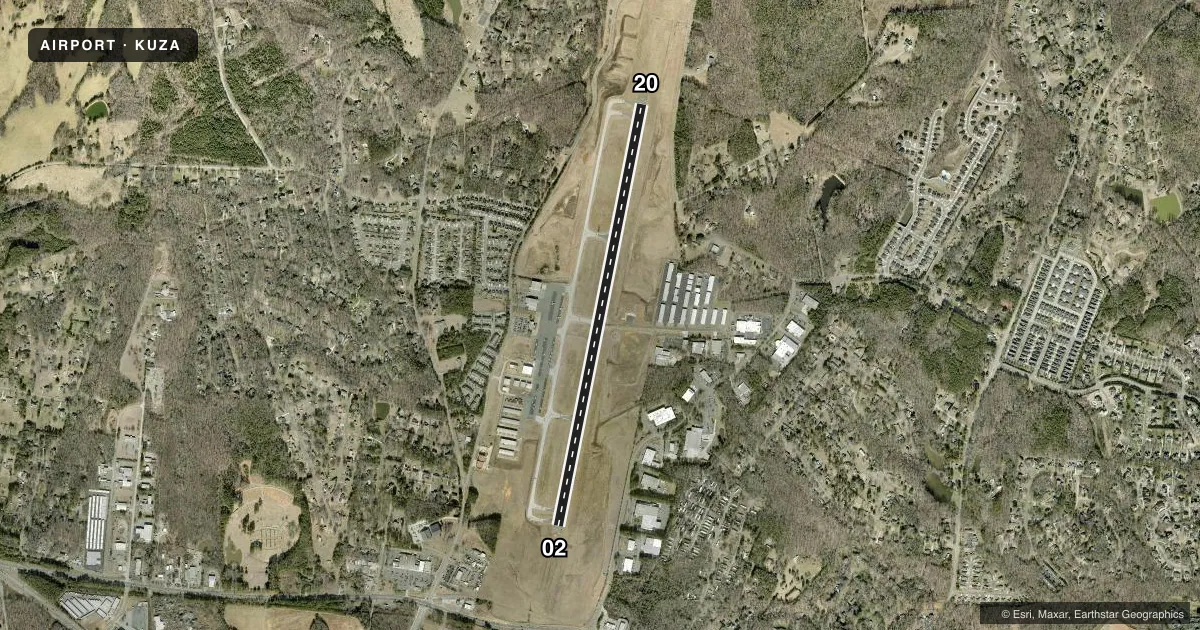
Airport sketch
Runways drawn to scale from FAA survey coordinates, rendered over satellite imagery. Not for navigation.
Approaches & charts
ILS · 1
Services on the field
Fuel grades, oxygen, maintenance, ramp storage and lighting — as declared to the FAA by the airport operator.
Fuel & services
- Fuel
- 100LLA
- Oxygen (bottled)
- High pressure
- Oxygen (bulk)
- Not available
- Airframe repair
- Major
- Power plant repair
- Major
- Other services
- AFRT,AMB,CHTR,INSTR,RNTL,SALES,SURV
Ramp & ground
- Transient storage
- Tie-down
- Hangar
- Landing fee
- No fee published
- Customs
- Not available
- Lighting schedule
- SEE RMK
- Beacon schedule
- SS-SR
- Beacon
- White / Green (civil land)(WG)
- Wind indicator
- Lighted
- Segmented circle
- Yes
Fuel & FBOs
Cheapest 100LL and Jet A on the field and nearby. Always confirm with the FBO before taxi.
Airport notes
Surface conditions, obstructions, local procedures, lighting outages and other notes published with each FAA cycle.
General notes
- WILDLIFE INVOF ARPT.
- VOLUNTARY NOISE ABATEMENT PROC IN EFCT.
- FOR CD IF UNA TO CTC ON FSS FREQ, CTC CHARLOTTE APCH AT 704-359-0241.
- GCO AVBL ON FREQ 121.725 TO CHARLOTTE APCH.
Lighting notes
- DUSK-2300. MIRL RWY 02/20 & MALSR RWY 02 PRESET MED INTST DUSK-2300; TO INCR INTST & ACTVT AFTER 2300 - CTAF.
Other notes
- MANAGERFBO - PILATUS AIRCRAFT USA, AARON COPE 803-366-5108.
VFR map & nearby airports
VFR sectional. Tap any ICAO chip to open that airport.
Key facts · KUZA
Answer card- ICAO
- KUZA
- Name
- ROCK HILL/YORK COUNTY/BRYANT FLD
- Location
- ROCK HILL, SOUTH CAROLINA
- Elevation
- 666.3 ft MSL
- Traffic pattern altitude
- 1,666.3 ft MSL (1,000 AGL)
- Control tower
- Non-towered (use CTAF)
- Total runways
- 1
- Longest runway
- 02/20 · 5,500 ft
- Published ILS approaches
- 1
- Published frequencies
- 4
- Magnetic variation
- 5°
- Current flight rules
- IFR
- Current wind
- 220° at 3 kt
- Favored runway now
- RWY 20
Rock Hill/York County/Bryant Fld sits in Rock Hill, South Carolina. Field elevation is 666.3 ft MSL. The airport has one runway. Runway 02/20 is 5,500 ft long with asphalt pavement. There is no control tower. The published pattern altitude is not listed, so use the standard 1,000 ft AGL for light piston traffic unless ATC or the current Chart Supplement says otherwise.
Instrument coverage includes one ILS approach to Runway 02. The field sits under Charlotte approach control for IFR services. Published remarks say the airport uses voluntary noise abatement procedures. Wildlife is also reported in the vicinity, so plan your arrival and departure with that in mind. Runway lighting is preset from dusk to 2300. The medium intensity approach lighting system on Runway 02 is also preset. After 2300, use CTAF to increase lighting intensity and activate the lights.
Pilatus, formerly Skytech, is the on-field FBO. It carries 100LL and Jet A. For clearance delivery, if Flight Service is not reachable, contact Charlotte Approach. First-time arrivals should also note the ground communications outlet on 121.725 to Charlotte Approach.