METAR & TAF KEQY
Current METAR
Observed 07:39Z
KEQY 270739Z AUTO 00000KT 4SM BR CLR 23/22 A2986 RMK AO2 T02280222
- Wind
- 000° @ 0 kt
- Visibility
- 4 SM
- Temp / Dew
- 23°C / 22°C
- Altimeter
- 29.86 inHg
- Clouds
- CLR
- Density alt
- 1,881 ft
- Ceiling
- Unlimited
- Rules
- MVFR
Airport info & contacts
Manager on record, flight service, ARTCC, attendance schedule and pattern altitude — published by the FAA and refreshed every 28 days.
Location
- From city
- 5 NM NW
- VFR sectional
- CHARLOTTE
- ARTCC
- ZTL · ATLANTA
- NOTAM facility
- EQY (NOTAM-D)
Airport manager
- Name
- MALCOLM WEEKS
- Phone
- 704-282-4730
- Address
- 3900 PAUL J. HELMS DRIVE, MONROE NC 28110
Flight service · Hours
- FSS RDU
- RALEIGH1-800-WX-BRIEF
- Attendance
- 0700-1900
Frequencies
Tap any row to copy the frequency to your clipboard.
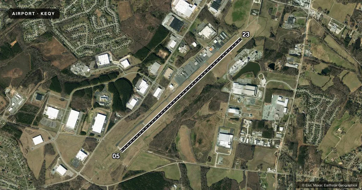
Runways & pattern
Full pagePattern entry · RWY 05
LEFT TRAFFICRunway end performance
| End | TORA | TODA | ASDA | LDA | VGSI | Approach lights | Obstruction |
|---|---|---|---|---|---|---|---|
| 05 | — | — | — | — | PAPI 4-box left(3°) | MALSR | 36', trees, 1963' from thr, 382' R of cntrln, slope 48 |
| 23 | — | — | — | — | PAPI 4-box left(3°) | — | 25', trees, 1095' from thr, 431' R of cntrln, slope 35 |
Declared distances in feet. TORA = takeoff run available, TODA = takeoff distance, ASDA = accelerate-stop, LDA = landing distance.
Airport sketch
Runways drawn to scale from FAA survey coordinates, rendered over satellite imagery. Not for navigation.
Approaches & charts
ILS · 1
Services on the field
Fuel grades, oxygen, maintenance, ramp storage and lighting — as declared to the FAA by the airport operator.
Fuel & services
- Fuel
- 100LLA1+
- Oxygen (bottled)
- HIGH/LOW
- Oxygen (bulk)
- Not available
- Airframe repair
- Major
- Power plant repair
- Major
- Other services
- AVNCS,CHTR,INSTR,RNTL,SALES
Ramp & ground
- Transient storage
- Tie-down
- Hangar
- Landing fee
- No fee published
- Customs
- Not available
- Lighting schedule
- SEE RMK
- Beacon schedule
- SS-SR
- Beacon
- White / Green (civil land)(WG)
- Wind indicator
- Lighted
- Segmented circle
- Yes
Fuel & FBOs
Cheapest 100LL and Jet A on the field and nearby. Always confirm with the FBO before taxi.
Airport notes
Surface conditions, obstructions, local procedures, lighting outages and other notes published with each FAA cycle.
General notes
- ARPT PHONE NUMBER 704-282-4730.
- DEER, WILDLIFE, AND BIRDS ON AND INVOF ARPT.
- RIGHT SIDE OF TWY A AT RWY 23 HAS STEEP SHOULDER DROP-OFF BTN RWY AND TWY A.
- FOR CD CTC CHARLOTTE APCH AT 704-359-0241.
Lighting notes
- ACTVT MALSR RWY 05; REIL RWY 23; HIRL RWY 05/23 - CTAF. ALL LIGHTS OPER DUSK-0000. AFTER 0000, ACTVT - 122.7. PAPI RWY 05 & 23 OPER CONSLY.
Fuel notes
- 100LLFUEL 24 HR CREDIT CARD SVC AVBL.
Approach & departure obstructions
- 2363 FT TREES LOCATED 0-200 FT FM THR AND OFFSET 401 FT L.
VFR map & nearby airports
VFR sectional. Tap any ICAO chip to open that airport.
Key facts · KEQY
Answer card- ICAO
- KEQY
- Name
- CHARLOTTE/MONROE EXEC
- Location
- MONROE, NORTH CAROLINA
- Elevation
- 682.5 ft MSL
- Traffic pattern altitude
- 1,682.5 ft MSL (1,000 AGL)
- Control tower
- Non-towered (use CTAF)
- Total runways
- 1
- Longest runway
- 05/23 · 7,001 ft
- Published ILS approaches
- 1
- Published frequencies
- 5
- Magnetic variation
- 6°
- Current flight rules
- MVFR
- Current wind
- 000° at 0 kt
- Favored runway now
- –
Charlotte/Monroe Executive Airport sits in Monroe, North Carolina. Field elevation is 682.5 ft MSL. The airport has one runway. Runway 05/23 is 7,001 ft long with an asphalt surface. There is one ILS approach. It serves runway 05.
This is an untowered field. Use CTAF 122.7 for local traffic. Pattern altitude is not published. Use the standard 1,000 ft AGL pattern unless ATC or the current Chart Supplement says otherwise. The airport sits in the Charlotte area, so expect busy traffic flow and stay sharp on radio calls. For clearance delivery, the published remark points pilots to Charlotte Approach.
Charlotte-Monroe Executive Airport is on the field. It carries 100LL and Jet A Prist. Fuel has 24-hour credit card service. Published lighting notes matter here. MALSR is on runway 05. REIL is on runway 23. High intensity runway lights are available for both ends. The lights operate from dusk to 0000 on CTAF. After 0000, activate the lights on 122.7. The PAPI for both runway ends operates continuously.
Watch runway 23 closely. The Chart Supplement notes 63-foot trees near the threshold, offset left. It also notes a steep shoulder drop-off on the right side of taxiway A near runway 23. Deer, wildlife and birds are also reported on and near the airport.