METAR & TAF KLKR
Current METAR
Observed 08:55Z
KLKR 270855Z AUTO 00000KT M1/4SM FG OVC002 23/23 A2986 RMK AO2
- Wind
- 000° @ 0 kt
- Visibility
- —
- Temp / Dew
- 23°C / 23°C
- Altimeter
- 29.86 inHg
- Clouds
- OVC
- Density alt
- 1,637 ft
- Ceiling
- 200 ft AGL
- Rules
- LIFR
Airport info & contacts
Manager on record, flight service, ARTCC, attendance schedule and pattern altitude — published by the FAA and refreshed every 28 days.
Location
- From city
- 4 NM W
- VFR sectional
- CHARLOTTE
- ARTCC
- ZTL · ATLANTA
- NOTAM facility
- AND (NOTAM-D)
Airport manager
- Name
- PAUL MOSES
- Phone
- (803) 285-1513
- Address
- 286 AVIATION BLVD, LANCASTER, LANCASTER SC 29720
Flight service · Hours
- FSS AND
- ANDERSON1-800-WX-BRIEF
- Attendance
- 0730-1500
Frequencies
Tap any row to copy the frequency to your clipboard.
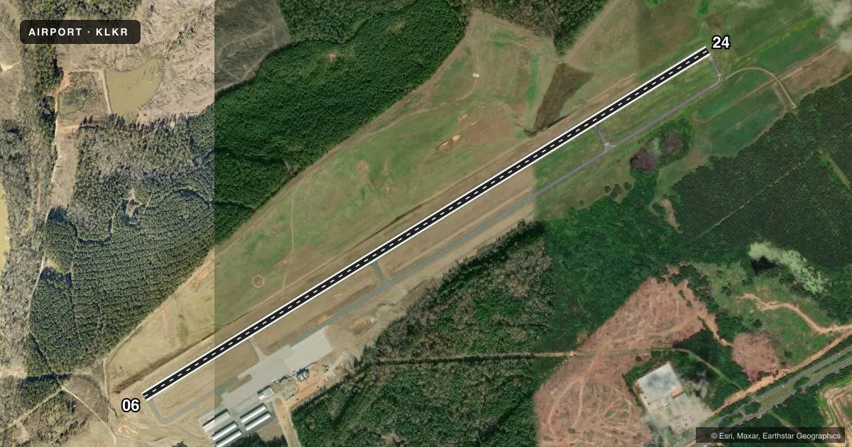
Runways & pattern
Full pagePattern entry · RWY 06
LEFT TRAFFICRunway end performance
| End | TORA | TODA | ASDA | LDA | VGSI | Approach lights | Obstruction |
|---|---|---|---|---|---|---|---|
| 06 | — | — | — | — | PAPI 2-box left(3°) | — | 17', tree, 629' from thr, 101' R of cntrln, slope 25 |
| 24 | — | — | — | — | PAPI 2-box left(3.15°) | — | 150', tree, 4473' from thr, 473' R of cntrln, slope 28 |
Declared distances in feet. TORA = takeoff run available, TODA = takeoff distance, ASDA = accelerate-stop, LDA = landing distance.
Airport sketch
Runways drawn to scale from FAA survey coordinates, rendered over satellite imagery. Not for navigation.
Approaches & charts
Services on the field
Fuel grades, oxygen, maintenance, ramp storage and lighting — as declared to the FAA by the airport operator.
Fuel & services
- Fuel
- 100LLA
- Oxygen (bulk)
- Not available
- Airframe repair
- Not available
- Power plant repair
- Not available
- Other services
- INSTR
Ramp & ground
- Transient storage
- Tie-down
- Hangar
- Landing fee
- Yes
- Customs
- Not available
- Lighting schedule
- SEE RMK
- Beacon schedule
- SS-SR
- Beacon
- White / Green (civil land)(WG)
- Wind indicator
- Lighted
- Segmented circle
- Yes
Fuel & FBOs
Cheapest 100LL and Jet A on the field and nearby. Always confirm with the FBO before taxi.
Airport notes
Surface conditions, obstructions, local procedures, lighting outages and other notes published with each FAA cycle.
General notes
- 25 FT DROP; 250 FT FM THR RWY 06.
- DEER ON & INVOF ARPT.
- GCO AVBL ON FREQ 121.725 TO CHARLOTTE APCH.
- SMALL ACFT MUST BE ON A TIE DOWN.
- FOR CD CTC CHARLOTTE APCH AT 704-359-0241.
- ARL APPLICATORS NOT PMTD DUE TO PAVEMENT CONDS.
Lighting notes
- ACTVT REIL RWY 06 & 24; MIRL RWY 06/24 - CTAF. PAPI RWY 06 & 24 OPR CONSLY.
Fuel notes
- 100LLFOR FUEL AFT HRS CALL 803-285-1513
VFR map & nearby airports
VFR sectional. Tap any ICAO chip to open that airport.
Key facts · KLKR
Answer card- ICAO
- KLKR
- Name
- LANCASTER COUNTY-MC WHIRTER FLD
- Location
- LANCASTER, SOUTH CAROLINA
- Elevation
- 485.9 ft MSL
- Traffic pattern altitude
- 1,485.9 ft MSL (1,000 AGL)
- Control tower
- Non-towered (use CTAF)
- Total runways
- 1
- Longest runway
- 06/24 · 6,004 ft
- Published ILS approaches
- 0
- Published frequencies
- 4
- Magnetic variation
- 7°
- Current flight rules
- LIFR
- Current wind
- 000° at 0 kt
- Favored runway now
- –
Lancaster County-Mc Whirter Fld sits in Lancaster, South Carolina. Field elevation is 485.9 ft MSL. The airport has one runway. Runway 06/24 is 6,004 ft long with concrete pavement. It is a non-towered field. Pattern altitude is not published, so use the standard 1,000 ft AGL for light piston traffic unless the current Chart Supplement says otherwise. That puts the pattern at about 1,486 ft MSL based on the listed field elevation.
No ILS approaches are published here. CTAF and UNICOM are both 122.725. Charlotte Approach works the area on 120.05 and 307.8. Clearance delivery is handled through Charlotte Approach. The field has runway end identifier lights on 06 and 24. Medium intensity runway lights are pilot-controlled on CTAF. PAPI is on continuously for both runway ends.
Lancaster County Airport is on the field. It carries 100LL and Jet A. For fuel after hours, call the field directly. Small aircraft must be tied down. Watch the runway 06 end. There is a 25 ft drop about 250 ft from the threshold. Deer are also reported on and near the airport. Aerial applicators are not permitted because of pavement conditions, so plan on standard GA use only.