METAR & TAF KAKH
Current METAR
Observed 01:54Z
KAKH 270154Z AUTO 21003KT 10SM CLR 24/23 A2990 RMK AO2 SLP118 T02440228
- Wind
- 210° @ 3 kt
- Visibility
- 10 SM
- Temp / Dew
- 24°C / 23°C
- Altimeter
- 29.90 inHg
- Clouds
- CLR
- Density alt
- 2,094 ft
- Ceiling
- Unlimited
- Rules
- VFR
Airport info & contacts
Manager on record, flight service, ARTCC, attendance schedule and pattern altitude — published by the FAA and refreshed every 28 days.
Location
- From city
- 4 NM S
- VFR sectional
- CHARLOTTE
- ARTCC
- ZTL · ATLANTA
- NOTAM facility
- AKH (NOTAM-D)
Airport manager
- Name
- STEVE HUSS
- Phone
- 704-869-7844
- Address
- 1126 GASTON DAY SCHOOL ROAD, GASTONIA NC 28056
Flight service · Hours
- FSS RDU
- RALEIGH1-800-WX-BRIEF
- Attendance
- MON-SUN · 0800-1700
Frequencies
Tap any row to copy the frequency to your clipboard.
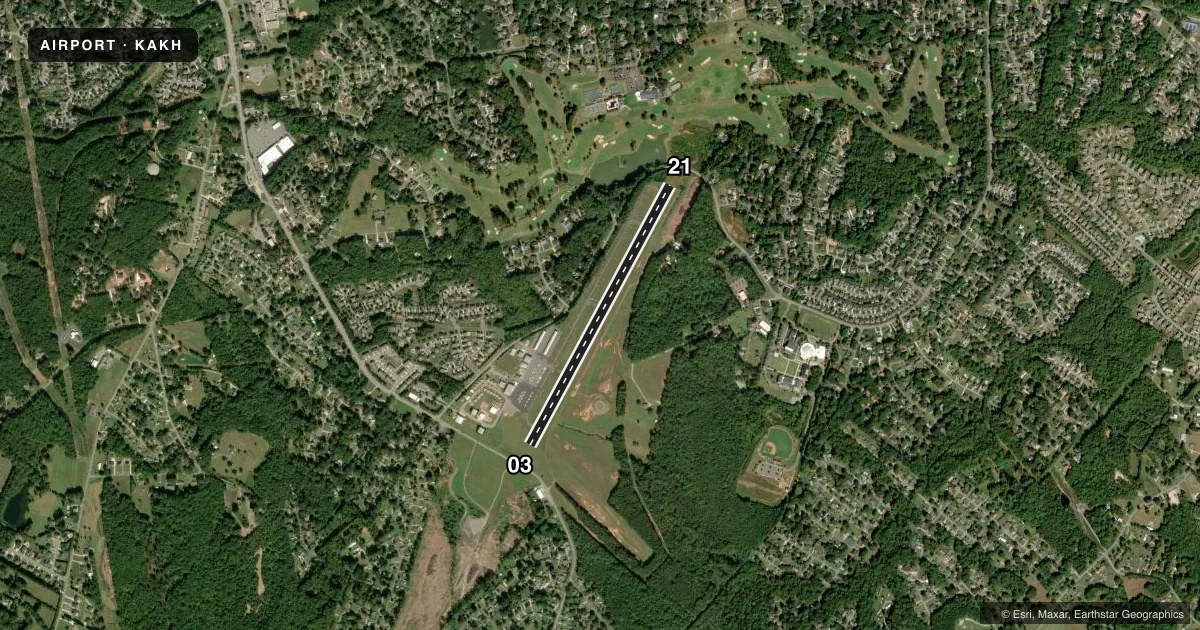
Runways & pattern
Full pagePattern entry · RWY 21
LEFT TRAFFICRunway end performance
| End | TORA | TODA | ASDA | LDA | VGSI | Approach lights | Obstruction |
|---|---|---|---|---|---|---|---|
| 03 | — | — | — | — | PAPI 2-box right(3°) | ODALS | 10', road, 279' from thr, 0' R of cntrln, slope 7 |
| 21 | — | — | — | — | PAPI 2-box left(3°) | — | 74', trees, 2902' from thr, 756' R of cntrln, slope 36 |
Declared distances in feet. TORA = takeoff run available, TODA = takeoff distance, ASDA = accelerate-stop, LDA = landing distance.
Airport sketch
Runways drawn to scale from FAA survey coordinates, rendered over satellite imagery. Not for navigation.
Approaches & charts
Services on the field
Fuel grades, oxygen, maintenance, ramp storage and lighting — as declared to the FAA by the airport operator.
Fuel & services
- Fuel
- 100LLA1+
- Oxygen (bottled)
- Not available
- Oxygen (bulk)
- Not available
- Airframe repair
- Major
- Power plant repair
- Major
- Other services
- AVNCS,CHTR
Ramp & ground
- Transient storage
- Tie-down
- Landing fee
- No fee published
- Customs
- Not available
- Lighting schedule
- SEE RMK
- Beacon schedule
- SS-SR
- Beacon
- White / Green (civil land)(WG)
- Wind indicator
- Lighted
- Segmented circle
- Yes
Fuel & FBOs
Cheapest 100LL and Jet A on the field and nearby. Always confirm with the FBO before taxi.
Airport notes
Surface conditions, obstructions, local procedures, lighting outages and other notes published with each FAA cycle.
General notes
- RWY 03 - 15 FT ROAD 292 FT FM THR L & R OF CNTRLN.
- RWY 21 - 50 FT DROP-OFF 300 FT FM DSPLCD THR L&R OF CNTRLN AND UNMKD PLINES 370 FT FM DSPLCD THR L&R OF CNTRLN.
- NOISE ABATEMENT: FROM 2200-0600 PILOTS ARE REQUESTED TO USE RWY 21 AS CALM WIND RWY & DO RUNUPS ON RAMP; NOT RWY END. TO AVOID LOW ALT TURNS TO THE WEST REQ CLNC THRU CLASS B ASP FROM CHARLOTTE APCH.
- DEER ON & INVOF ARPT.
- FOR CD CTC CHARLOTTE APCH AT 704-359-0241.
- RWY 03/21 NO LINE OF SIGHT BTN RWY ENDS.
Lighting notes
- ACTVT ODALS RWY 03; PAPI RWY 03 & 21; MIRL RWY 03/21 - CTAF.
Approach & departure obstructions
- 2110 FT BRUSH 82 FT FM END OF RWY 105 FT RIGHT OF CNTRLN.
- 21APCH SLOPE 43:1 TO DSPLCD THR DUE TO 66 FT TREES LOCATED 3099 FT FRM DSPLCD THR OFFSET 796 FT RIGHT OF CNTRLN.
Other notes
- 1UNATNDD CHRISTMAS DAY.
- 1FOR SERVICE AFTER HOURS CALL 704-813-6040
- OWNERSTEVE HUSS.
VFR map & nearby airports
VFR sectional. Tap any ICAO chip to open that airport.
Key facts · KAKH
Answer card- ICAO
- KAKH
- Name
- GASTONIA MUNI
- Location
- GASTONIA, NORTH CAROLINA
- Elevation
- 797.9 ft MSL
- Traffic pattern altitude
- 1,797.9 ft MSL (1,000 AGL)
- Control tower
- Non-towered (use CTAF)
- Total runways
- 1
- Longest runway
- 03/21 · 3,769 ft
- Published ILS approaches
- 0
- Published frequencies
- 5
- Magnetic variation
- 6°
- Current flight rules
- VFR
- Current wind
- 210° at 3 kt
- Favored runway now
- RWY 21
Gastonia Muni sits in Gastonia, North Carolina. The field elevation is 797.9 ft MSL. It has one runway, 03/21, which is 3,769 ft long and asphalt. There is no control tower. Towered services are handled through Charlotte Approach. Published frequencies include CTAF 123.0 and UNICOM 123.0.
No ILS approaches are published here. Runway lighting on 03/21 is activated by CTAF. The field also has ODALS on runway 03 and PAPI on both runway ends. Pattern altitude is not published. Use 1,000 ft AGL for light piston traffic unless the current Chart Supplement says otherwise. That puts the standard pattern near 1,798 ft MSL at this field.
Academy of Aviation is on the field. It carries 100LL and Jet A with Prist. The airport remarks matter here. Charlotte Approach clearance delivery is listed at 704-359-0241. Noise abatement asks pilots to use runway 21 as the calm wind runway from 2200 to 0600. Runups should be done on the ramp, not at the runway end. The field also has deer in the area. Runway 21 has tree and power line issues near the displaced threshold. Runway 03 has a road close in on final. The runway ends do not have line of sight to each other, so brief your taxi and departure plan before you roll.