METAR & TAF 14A
14A does not publish a METAR.
Showing the nearest reporting station: KSVH (STATESVILLE RGNL) · 9.5 NM away. Conditions at 14A may differ.
METAR · KSVH
Observed 10:55Z
KSVH 271055Z AUTO 00000KT M1/4SM FG OVC003 22/22 A2992 RMK AO2 T02160215
- Wind
- 000° @ 0 kt
- Visibility
- —
- Temp / Dew
- 22°C / 22°C
- Altimeter
- 29.92 inHg
- Clouds
- OVC
- Density alt
- 1,881 ft
- Ceiling
- 300 ft AGL
- Rules
- LIFR
Airport info & contacts
Manager on record, flight service, ARTCC, attendance schedule and pattern altitude — published by the FAA and refreshed every 28 days.
Location
- From city
- 5 NM NW
- VFR sectional
- CHARLOTTE
- ARTCC
- ZTL · ATLANTA
- NOTAM facility
- RDU (NOTAM-D)
Airport manager
- Name
- DEBBY DENNIS
- Phone
- 704-880-1563
- Address
- 341 NORMANDY ROAD, MOORESVILLE NC 28117
Flight service · Hours
- FSS RDU
- RALEIGH1-800-WX-BRIEF
- Attendance
- MON - FRI · 0800-1700
- SAT - SUN · 1000-1600
Frequencies
Tap any row to copy the frequency to your clipboard.
Runways & pattern
Full pagePattern entry · RWY 14
LEFT TRAFFICRunway end performance
| End | TORA | TODA | ASDA | LDA | VGSI | Approach lights | Obstruction |
|---|---|---|---|---|---|---|---|
| 14 | — | — | — | — | — | — | 82', trees, 673' from thr, 262' R of cntrln, slope 5 |
| 32 | — | — | — | — | — | — | 42', trees, 469' from thr, 132' R of cntrln, slope 6 |
Declared distances in feet. TORA = takeoff run available, TODA = takeoff distance, ASDA = accelerate-stop, LDA = landing distance.
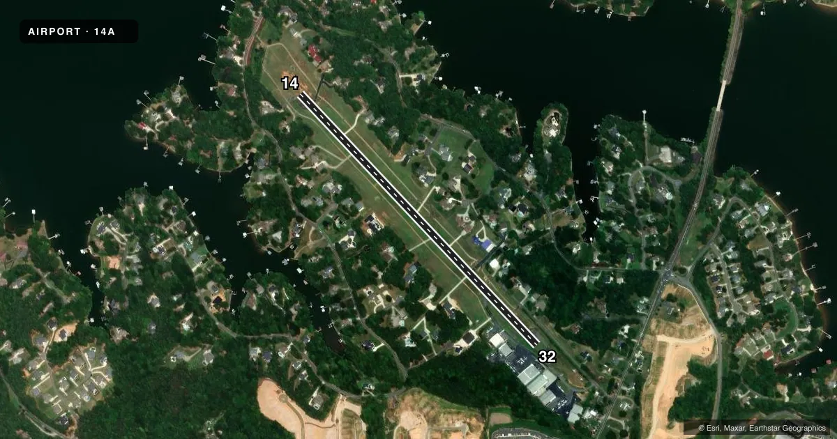
Airport sketch
Runways drawn to scale from FAA survey coordinates, rendered over satellite imagery. Not for navigation.
Approaches & charts
Services on the field
Fuel grades, oxygen, maintenance, ramp storage and lighting — as declared to the FAA by the airport operator.
Fuel & services
- Fuel
- 100LL
- Oxygen (bottled)
- Not available
- Oxygen (bulk)
- Not available
- Airframe repair
- Major
- Power plant repair
- Major
- Other services
- INSTR,RNTL
Ramp & ground
- Transient storage
- Tie-down
- Hangar
- Landing fee
- No fee published
- Customs
- Not available
- Lighting schedule
- SEE RMK
- Beacon schedule
- SS-SR
- Beacon
- White / Green (civil land)(WG)
- Wind indicator
- Yes
- Segmented circle
- Yes
Fuel & FBOs
Cheapest 100LL and Jet A on the field and nearby. Always confirm with the FBO before taxi.
Airport notes
Surface conditions, obstructions, local procedures, lighting outages and other notes published with each FAA cycle.
General notes
- ACFT TAXIING ON GRASS INVOF RESIDENTIAL AIRPARK HNGR ACCESS.
- RWY 14 HAS UPHILL GRADE.
- DEP RWY 14 HDG 160 DEGS TO AVOID SCHOOL.
- NOISE SENSITIVE AREA AVOID DEPS BTN 2300 AND 0600. DEP RWY 32 HDG 324 DEG UNTIL OVER LAKE TO AVOID HOUSES.
- RWY 32 HAS 10 FT DROP-OFF 5 FT FM LEFT SIDE OF PAVEMENT AND ACFT PARKED 200 FT FM END OF RWY 100 FT RIGHT OF CNTRLN.
- FOR CD CTC APCH AT 704-359-0241. CALL WHEN AT RWY READY FOR DEP.
- CTC RACE CITY FLT OPS FOR TIEDOWN, HNGR, AND FUEL INFO AT 704-662-6227.
- ACFT MAX WT 8000 LBS.
- BACK TAXI ON RWY - NO PARL TWYS.
- NO HEL TRG.
- DEER INVOF RWY.
Lighting notes
- ACTVT MIRL RWY 14/32 - CTAF (7 CLICKS).
Runway surface & condition
- 14/32RWY 14 HAS DSPLCD THR LIGHTS BUT NO LIGHTS AT BEGINNING OF PAVEMENT.
Approach & departure obstructions
- 14+10 FT TERRAIN 100 FT FM THR, 50 FT LEFT OF CNTRLN, AND 20 FT SUPPL LDI (TET) 100 FT FM THR, 100 FT LEFT OF CNTRLN.
- 32+48 TREES LINE 0-200 FT FM THR OFFSET 116 FT RIGHT.
- 14RWY 14/32 NUMBERS NSTD SIZE.
- 14APCH RATIO 9:1 AT DSPLCD THR.
Other notes
- PRVDD VFR; APCH SLOPE SFCS CLEAR FOR 20:1; LTG FOR APCH END RWY 14 CHGD TO SHOW GREEN ON APCH SIDE AND RED ON RWY SIDE; RMK ADDED TO A/FD RE RWY 32 APCH/LDG & LGT; AND HGRS OBSTRUCTION LGTD IF NIGHT APCHS/LDG TO RWY 32 AUTH.
- UNLGTD SEGMENTED CRC.
- 1ARPT UNATNDD ALL MAJ HOLS.
VFR map & nearby airports
VFR sectional. Tap any ICAO chip to open that airport.
Key facts · 14A
Answer card- ICAO
- 14A
- Name
- LAKE NORMAN AIRPARK
- Location
- MOORESVILLE, NORTH CAROLINA
- Elevation
- 839.4 ft MSL
- Traffic pattern altitude
- 1,839.4 ft MSL (1,000 AGL)
- Control tower
- Non-towered (use CTAF)
- Total runways
- 1
- Longest runway
- 14/32 · 3,147 ft
- Published ILS approaches
- 0
- Published frequencies
- 4
- Magnetic variation
- 7°
- Current flight rules
- LIFR
- Current wind
- 000° at 0 kt
- Favored runway now
- –
Lake Norman Airpark sits in Mooresville, North Carolina. The field elevation is 839.4 ft MSL. It has one runway. Runway 14/32 is 3,147 ft of asphalt, so plan performance with that length in mind. There is no control tower. CTAF and UNICOM are both 122.8. Approach and departure support is with Charlotte on 134.75 or 257.2.
No ILS approaches are published here. The pattern altitude is not published, so use the standard 1,000 ft AGL for light piston operations unless the current Chart Supplement says otherwise. Race City Flight Operations is on the field. It carries 100LL. Call them directly at (704) 662-6227 for current service details.
A few remarks matter here. Runway 14 has displaced threshold lighting, but no lights at the pavement start. The runway 14 approach end lighting has a modified red and green setup. Runway 32 has a drop-off near the left side of the pavement. Deer are reported in the area. Noise-sensitive departures should be avoided between 2300 and 0600. For departure to runway 32, the published track keeps you heading 324 degrees until over the lake to stay clear of houses. If you need clearance delivery, contact approach at 704-359-0241 and call when ready at the runway.