METAR & TAF KEHO
Current METAR
Observed 10:35Z
KEHO 271035Z AUTO 00000KT 1/2SM FG OVC001 22/21 A2989 RMK AO2 T02150210
- Wind
- 000° @ 0 kt
- Visibility
- 0.5 SM
- Temp / Dew
- 22°C / 21°C
- Altimeter
- 29.89 inHg
- Clouds
- OVC
- Density alt
- 1,927 ft
- Ceiling
- 100 ft AGL
- Rules
- LIFR
Airport info & contacts
Manager on record, flight service, ARTCC, attendance schedule and pattern altitude — published by the FAA and refreshed every 28 days.
Location
- From city
- 3 NM SW
- VFR sectional
- CHARLOTTE
- ARTCC
- ZTL · ATLANTA
- NOTAM facility
- EHO (NOTAM-D)
Airport manager
- Name
- JACK POOLE
- Phone
- 704-487-1161
- Address
- 830 COLLEGE AVE, HIGHWAY 150, SHELBY NC 28152
Flight service · Hours
- FSS RDU
- RALEIGH1-800-WX-BRIEF
- Attendance
- MON-FRI · 0800-1700
- SUN · 1300-1600
- SAT · 1000-1500
Frequencies
Tap any row to copy the frequency to your clipboard.
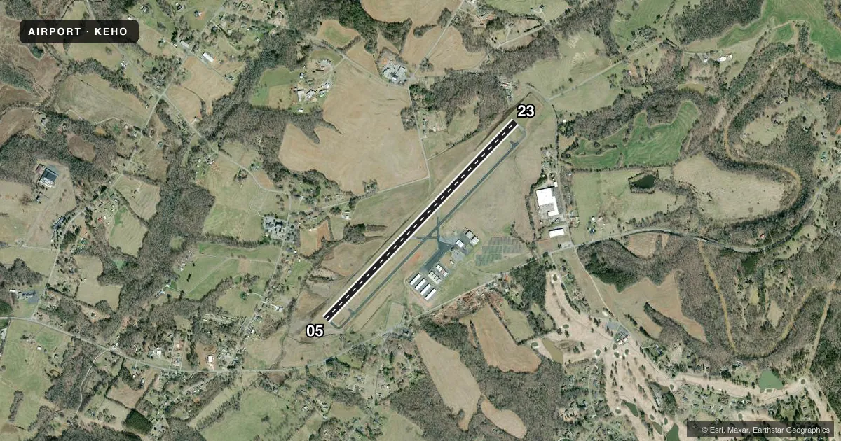
Runways & pattern
Full pagePattern entry · RWY 05
LEFT TRAFFICRunway end performance
| End | TORA | TODA | ASDA | LDA | VGSI | Approach lights | Obstruction |
|---|---|---|---|---|---|---|---|
| 05 | — | — | — | — | PAPI 2-box left(3°) | — | 44', trees, 955' from thr, 307' R of cntrln, slope 17 |
| 23 | — | — | — | — | PAPI 2-box left(3°) | — | 40', trees, 994' from thr, 38' R of cntrln, slope 19 |
Declared distances in feet. TORA = takeoff run available, TODA = takeoff distance, ASDA = accelerate-stop, LDA = landing distance.
Airport sketch
Runways drawn to scale from FAA survey coordinates, rendered over satellite imagery. Not for navigation.
Approaches & charts
Services on the field
Fuel grades, oxygen, maintenance, ramp storage and lighting — as declared to the FAA by the airport operator.
Fuel & services
- Fuel
- 100LLA1+
- Oxygen (bottled)
- Not available
- Oxygen (bulk)
- Not available
- Airframe repair
- Major
- Power plant repair
- Major
- Other services
- INSTR,RNTL
Ramp & ground
- Transient storage
- Tie-down
- Landing fee
- No fee published
- Customs
- Not available
- Lighting schedule
- SEE RMK
- Beacon schedule
- SS-SR
- Beacon
- White / Green (civil land)(WG)
- Wind indicator
- Lighted
- Segmented circle
- Yes
Fuel & FBOs
Cheapest 100LL and Jet A on the field and nearby. Always confirm with the FBO before taxi.
Airport notes
Surface conditions, obstructions, local procedures, lighting outages and other notes published with each FAA cycle.
General notes
- FOR SERVICE AFTER HOURS CALL 704 284-3321.
- RY 23 HAS 35 FT DROP-OFF 600 FT FM THLD 0B.
- RY 05 HAS 45 FT DROP-OFF 100 FT FM THLD 0B.
- FOR CD CTC CHARLOTTE APCH AT 704-359-0241.
- REFER TO CHARLOTTE SECTIONAL CHART FOR TOWERS OFF BOTH RWY ENDS.
Lighting notes
- DUSK-2300. AFTER 2300 ACTVT MIRL RWY 05/23 - CTAF. PAPI RWY 05 & 23 OPER CONSLY.
Fuel notes
- 100LL100LL FUEL 24 HR CREDIT CARD SVC AVBL.
VFR map & nearby airports
VFR sectional. Tap any ICAO chip to open that airport.
Key facts · KEHO
Answer card- ICAO
- KEHO
- Name
- SHELBY-CLEVELAND COUNTY RGNL
- Location
- SHELBY, NORTH CAROLINA
- Elevation
- 846.6 ft MSL
- Traffic pattern altitude
- 1,846.6 ft MSL (1,000 AGL)
- Control tower
- Non-towered (use CTAF)
- Total runways
- 1
- Longest runway
- 05/23 · 5,001 ft
- Published ILS approaches
- 0
- Published frequencies
- 4
- Magnetic variation
- 6°
- Current flight rules
- LIFR
- Current wind
- 000° at 0 kt
- Favored runway now
- –
Shelby-Cleveland County Regional Airport sits in Shelby, North Carolina. Field elevation is 846.6 ft MSL. The airport has one runway. Runway 05/23 is 5,001 ft long. There is no control tower. No ILS approaches are published here. The pattern altitude is not published, so use the standard 1,000 ft AGL for light piston traffic unless the current Chart Supplement says otherwise.
The on-field FBO is Shelby-Cleveland County Regional Airport. It carries AVGAS 100LL and JET A Prist. 100LL is available 24 hours with credit card service. That is useful for late arrivals or early departures. Published remarks also call out drop-offs near both runway ends. Runway 05 has a 45-foot drop-off about 100 feet from the threshold. Runway 23 has a 35-foot drop-off about 600 feet from the threshold. Plan your rollout and takeoff with that in mind.
The field uses CTAF 122.8. UNICOM is also 122.8. After 2300, medium intensity runway lights on 05/23 are activated on CTAF. PAPI on both ends operates continuously. For clearance delivery, contact Charlotte Approach. This is a non-towered field with Charlotte-area traffic nearby, so keep a sharp scan and check the current sectional for the towers noted in the remarks.