METAR & TAF KFQD
Current METAR
Observed 12:35Z
KFQD 261235Z AUTO 35003KT 10SM SCT005 SCT035 BKN075 21/21 A3001 RMK AO2 LTG DSNT E P0022
- Wind
- 350° @ 3 kt
- Visibility
- 10 SM
- Temp / Dew
- 21°C / 21°C
- Altimeter
- 30.01 inHg
- Clouds
- BKN
- Density alt
- 1,944 ft
- Ceiling
- 7,500 ft AGL
- Rules
- VFR
Airport info & contacts
Manager on record, flight service, ARTCC, attendance schedule and pattern altitude — published by the FAA and refreshed every 28 days.
Location
- From city
- 3 NM N
- VFR sectional
- CHARLOTTE
- ARTCC
- ZTL · ATLANTA
- NOTAM facility
- FQD (NOTAM-D)
Airport manager
- Name
- DEVON RAISCH
- Phone
- (828) 287-0800
- Address
- 110 MARCHMAN FIELD DRIVE, SUITE 102, RUTHERFORDTON NC 28139
Flight service · Hours
- FSS RDU
- RALEIGH1-800-WX-BRIEF
- Attendance
- 0900-1800
Frequencies
Tap any row to copy the frequency to your clipboard.
Runways & pattern
Full pagePattern entry · RWY 01
LEFT TRAFFICRunway end performance
| End | TORA | TODA | ASDA | LDA | VGSI | Approach lights | Obstruction |
|---|---|---|---|---|---|---|---|
| 01 | — | — | — | — | PAPI 2-box left(3°) | — | 27', trees, 804' from thr, 288' R of cntrln, slope 22 |
| 19 | — | — | — | — | PAPI 2-box left(3.25°) | — | 24', trees, 327' from thr, 254' R of cntrln, slope 5 |
Declared distances in feet. TORA = takeoff run available, TODA = takeoff distance, ASDA = accelerate-stop, LDA = landing distance.
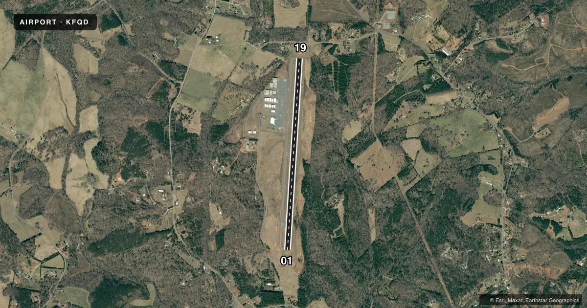
Airport sketch
Runways drawn to scale from FAA survey coordinates, rendered over satellite imagery. Not for navigation.
Approaches & charts
ILS · 1
Services on the field
Fuel grades, oxygen, maintenance, ramp storage and lighting — as declared to the FAA by the airport operator.
Fuel & services
- Fuel
- 100LLA1+
- Airframe repair
- Major
- Power plant repair
- Major
- Other services
- INSTR,RNTL,SALES
Ramp & ground
- Transient storage
- Tie-down
- Hangar
- Landing fee
- No fee published
- Customs
- Not available
- Lighting schedule
- SEE RMK
- Beacon schedule
- SS-SR
- Beacon
- White / Green (civil land)(WG)
- Wind indicator
- Lighted
- Segmented circle
- No
Fuel & FBOs
Cheapest 100LL and Jet A on the field and nearby. Always confirm with the FBO before taxi.
Airport notes
Surface conditions, obstructions, local procedures, lighting outages and other notes published with each FAA cycle.
General notes
- RWY 01 HAS 100 FT DROP-OFF 315 FT FM THR OFFSET 140 FT RIGHT AND 160 FT LEFT OF CNTRLN; AND 100 FT DROP-OFF 700-900 FT ALONG CNTRLN OFFSET 80 FT RIGHT.
- DEER IN VICINITY OF ARPT.
- FOR CD CTC GREER APCH AT 864-877-8275. WHEN GREER APCH CLSD, FOR CD CTC ATLANTA ARTCC AT 770-210-7692.
- TWY A TOWARD RWY 1 HAS 30 FT DROP-OFF 60 FT RIGHT OF CNTRLN.
- RWY 19 HAS 12 FT UNMARKED POWER LINES 440 FT FM THR BOTH SIDES OF CNTRLN.
Lighting notes
- ACTVT REIL RWY 01 & 19; PAPI RWY 01 & 19; MIRL RWY 01/19 - CTAF.
Fuel notes
- 100LL100LL AND JET A 24 SELF SVC FUEL AVBL WITH CREDIT CARD.
Approach & departure obstructions
- 196 FT FENCE 0-200 FT FM THR OFFSET 182 FT LEFT OF CNTRLN.
Other notes
- MANAGERMGR MOBILE PH# 828-748-5480.
VFR map & nearby airports
VFR sectional. Tap any ICAO chip to open that airport.
Key facts · KFQD
Answer card- ICAO
- KFQD
- Name
- RUTHERFORD COUNTY/MARCHMAN FLD
- Location
- RUTHERFORDTON, NORTH CAROLINA
- Elevation
- 1,077.3 ft MSL
- Traffic pattern altitude
- 2,077.3 ft MSL (1,000 AGL)
- Control tower
- Non-towered (use CTAF)
- Total runways
- 1
- Longest runway
- 01/19 · 5,000 ft
- Published ILS approaches
- 1
- Published frequencies
- 4
- Magnetic variation
- 5°
- Current flight rules
- VFR
- Current wind
- 350° at 3 kt
- Favored runway now
- RWY 01
Rutherford County/Marchman Fld (KFQD) sits in Rutherfordton, North Carolina. The field elevation is 1,077.3 ft MSL. It has one asphalt runway, 01/19, which is 5,000 ft long. There is no control tower. The pattern altitude is not published, so plan on the standard 1,000 ft AGL for light piston traffic unless the current FAA Chart Supplement says otherwise. One ILS approach is published for runway 01.
The on-field FBO is Rutherford County Airport. It carries 100LL and Jet A. 24-hour self-service fuel is available with a credit card. Runway and taxiway lighting are pilot-controlled on CTAF. Runway end identifier lights and PAPI are installed on both runway ends. For clearance delivery, Greer Approach handles it when open. When Greer is closed, Atlanta ARTCC handles clearance delivery.
First-time pilots should pay close attention to the published runway remarks. Runway 01 has a drop-off near the threshold and another drop-off farther down the centerline. Taxiway A toward runway 1 also has a drop-off near the centerline. Runway 19 has a fence near the threshold and unmarked power lines close in. Deer are also reported in the area. That makes a careful taxi and landing scan important here, especially at night or in low light.