METAR & TAF KHKY
Current METAR
Observed 09:53Z
KHKY 270953Z AUTO 00000KT 10SM CLR 21/21 A2988 RMK AO2 SLP096 T02110206 $
- Wind
- 000° @ 0 kt
- Visibility
- 10 SM
- Temp / Dew
- 21°C / 21°C
- Altimeter
- 29.88 inHg
- Clouds
- CLR
- Density alt
- 2,245 ft
- Ceiling
- Unlimited
- Rules
- VFR
Airport info & contacts
Manager on record, flight service, ARTCC, attendance schedule and pattern altitude — published by the FAA and refreshed every 28 days.
Location
- From city
- 3 NM W
- VFR sectional
- CHARLOTTE
- ARTCC
- ZTL · ATLANTA
- NOTAM facility
- HKY (NOTAM-D)
Airport manager
- Name
- CHAD HUNSUCKER
- Phone
- 828-358-8473
- Address
- 3101 9TH AVE DR NW, HICKORY NC 28601
Flight service · Hours
- FSS RDU
- RALEIGH1-800-WX-BRIEF
- Attendance
- MON-FRI · 0700-1900
- SAT- SUN · 0700-1900
Frequencies
Tap any row to copy the frequency to your clipboard.
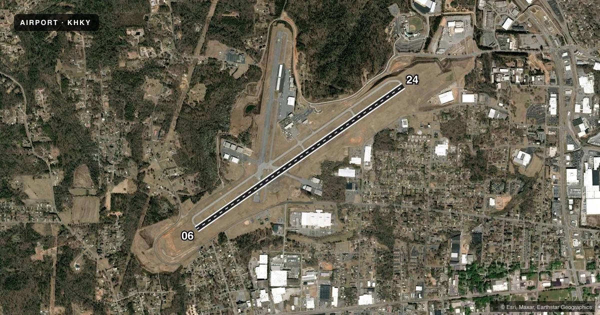
Runways & pattern
Full pagePattern entry · RWY 06
LEFT TRAFFICRunway end performance
| End | TORA | TODA | ASDA | LDA | VGSI | Approach lights | Obstruction |
|---|---|---|---|---|---|---|---|
| 06 | 6,401' | 6,401' | 6,401' | 6,401' | PAPI 4-box left(3°) | — | 68', trees, 1560' from thr, 300' R of cntrln, slope 20 |
| 24 | 6,401' | 6,401' | 6,401' | 6,401' | PAPI 4-box left(3°) | MALSR | — |
Declared distances in feet. TORA = takeoff run available, TODA = takeoff distance, ASDA = accelerate-stop, LDA = landing distance.
Airport sketch
Runways drawn to scale from FAA survey coordinates, rendered over satellite imagery. Not for navigation.
Approaches & charts
ILS · 1
Services on the field
Fuel grades, oxygen, maintenance, ramp storage and lighting — as declared to the FAA by the airport operator.
Fuel & services
- Fuel
- 100LLA1+
- Oxygen (bottled)
- Not available
- Oxygen (bulk)
- HIGH/LOW
- Airframe repair
- Major
- Power plant repair
- Major
- Other services
- AFRT,CHTR,INSTR,RNTL,SALES
Ramp & ground
- Transient storage
- Tie-down
- Hangar
- Landing fee
- No fee published
- Customs
- Not available
- Lighting schedule
- SEE RMK
- Beacon schedule
- SS-SR
- Beacon
- White / Green (civil land)(WG)
- Wind indicator
- Lighted
- Segmented circle
- Yes
Fuel & FBOs
Cheapest 100LL and Jet A on the field and nearby. Always confirm with the FBO before taxi.
Airport notes
Surface conditions, obstructions, local procedures, lighting outages and other notes published with each FAA cycle.
General notes
- AFT HRS SVCS CALL 828-327-0147.
Lighting notes
- DUSK-DAWN. ACTVT MALSR RWY 24; PAPI RWY 24; HIRL RWY 06/24 - CTAF (2100-0700). PAPI RWY 06 OPR CONSLY.
Fuel notes
- 100LL100LL AVBL AFT HRS WITH CREDIT CARD.
Runway surface & condition
- 06/24PCR VALUE: 550/F/B/X/T
Other notes
- AND BURKE COUNTY.
- CLSD TO UNSKED ACR OPNS WITH MORE THAN 30 PSGR SEATS EXCP 24 HR PPR CALL AMGR 828-327-0147.
- 1SVCS AVAIL M-F 0700-1900 LCL / S & S 0700-1900 LCL. AFT HRS SVCS CALL 828-327-0147.
VFR map & nearby airports
VFR sectional. Tap any ICAO chip to open that airport.
Key facts · KHKY
Answer card- ICAO
- KHKY
- Name
- HICKORY RGNL
- Location
- HICKORY, NORTH CAROLINA
- Elevation
- 1,189.6 ft MSL
- Traffic pattern altitude
- 2,189.6 ft MSL (1,000 AGL)
- Control tower
- Towered · 0700-2100
- Total runways
- 1
- Longest runway
- 06/24 · 6,401 ft
- Published ILS approaches
- 1
- Published frequencies
- 4
- Magnetic variation
- 6°
- Current flight rules
- VFR
- Current wind
- 000° at 0 kt
- Favored runway now
- –
Hickory Regional Airport sits in Hickory, North Carolina, in Burke County. The field elevation is 1,189.6 ft MSL. It has one runway, 06/24 and the longest runway is 6,401 ft of asphalt. The airport is towered. The control tower hours are 0700 to 2100 local. There is one ILS approach. It serves runway 24. Pattern altitude is not published. Use standard 1,000 ft AGL unless the current Chart Supplement says otherwise.
The on-field FBO is Hickory Regional Airport. It carries 100LL and Jet A with Prist. Call (828) 327-0147 for current service status or after-hours help. Published remarks say 100LL is available after hours with credit card payment. Lighting is available from dusk to dawn. The runway 24 approach lighting system includes MALSR and a PAPI. Runway 06 also has a PAPI. High intensity runway lights are available on 06 and 24. They are controlled by CTAF from 2100 to 0700.
For a first-time arrival, the big items are the tower schedule, the single runway layout and the instrument setup to 24. The airport is in a higher-elevation part of North Carolina, so expect performance to be a little different than at sea level. Check the current Chart Supplement for any noise or operational notes before you go.