METAR & TAF KAFP
Current METAR
Observed 06:35Z
KAFP 270635Z AUTO 00000KT 10SM SCT045 24/24 A2988 RMK AO2 T02410235
- Wind
- 000° @ 0 kt
- Visibility
- 10 SM
- Temp / Dew
- 24°C / 24°C
- Altimeter
- 29.88 inHg
- Clouds
- SCT
- Density alt
- 1,501 ft
- Ceiling
- Unlimited
- Rules
- VFR
Airport info & contacts
Manager on record, flight service, ARTCC, attendance schedule and pattern altitude — published by the FAA and refreshed every 28 days.
Location
- From city
- 3 NM N
- VFR sectional
- CHARLOTTE
- ARTCC
- ZTL · ATLANTA
- NOTAM facility
- RDU (NOTAM-D)
Airport manager
- Name
- REX EDWARDS
- Phone
- (704) 389-0633
- Address
- 2980 AIRPORT ROAD, WADESBORO NC 28170
Flight service · Hours
- FSS RDU
- RALEIGH1-800-WX-BRIEF
- Attendance
- MON-FRI · 0830-1700
Frequencies
Tap any row to copy the frequency to your clipboard.
Runways & pattern
Full pagePattern entry · RWY 16
LEFT TRAFFICRunway end performance
| End | TORA | TODA | ASDA | LDA | VGSI | Approach lights | Obstruction |
|---|---|---|---|---|---|---|---|
| 16 | — | — | — | — | PAPI 4-box left(3°) | — | 83', trees, 1426' from thr, 221' R of cntrln, slope 14 |
| 34 | — | — | — | — | PAPI 4-box left(3°) | — | 23', trees, 579' from thr, 356' R of cntrln, slope 16 |
Declared distances in feet. TORA = takeoff run available, TODA = takeoff distance, ASDA = accelerate-stop, LDA = landing distance.
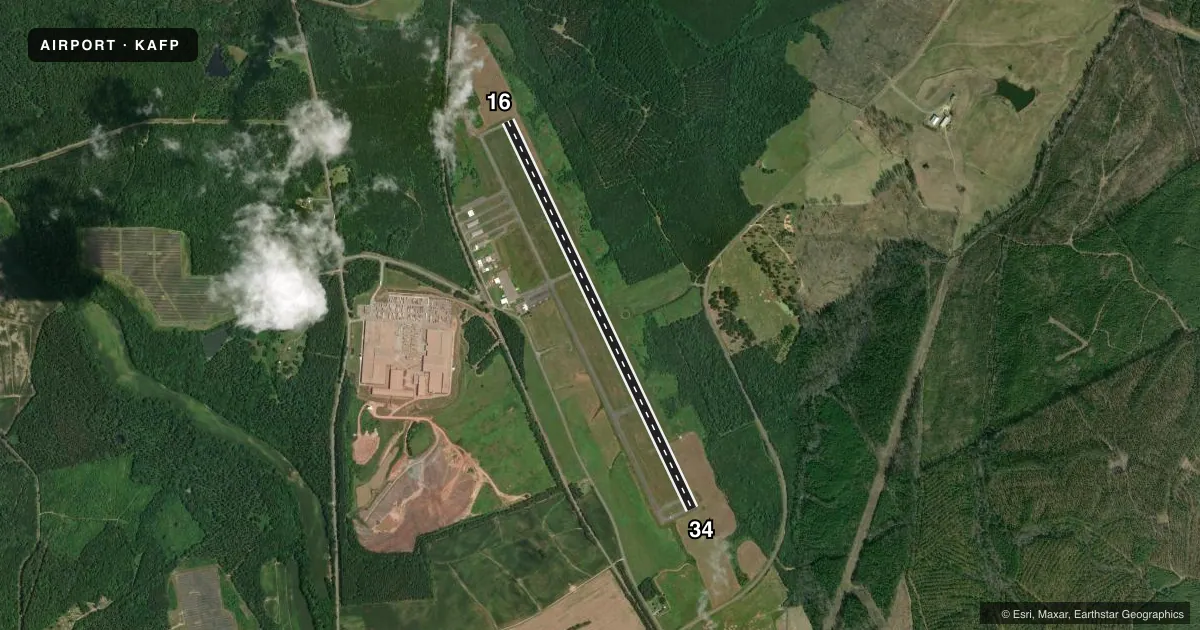
Airport sketch
Runways drawn to scale from FAA survey coordinates, rendered over satellite imagery. Not for navigation.
Approaches & charts
ILS · 1
Services on the field
Fuel grades, oxygen, maintenance, ramp storage and lighting — as declared to the FAA by the airport operator.
Fuel & services
- Fuel
- 100LLA1+
- Oxygen (bottled)
- Not available
- Oxygen (bulk)
- Not available
- Airframe repair
- Not available
- Power plant repair
- Not available
Ramp & ground
- Transient storage
- Tie-down
- Landing fee
- No fee published
- Customs
- Not available
- Lighting schedule
- SEE RMK
- Beacon schedule
- SS-SR
- Beacon
- White / Green (civil land)(WG)
- Wind indicator
- Lighted
- Segmented circle
- Yes
Fuel & FBOs
Cheapest 100LL and Jet A on the field and nearby. Always confirm with the FBO before taxi.
Airport notes
Surface conditions, obstructions, local procedures, lighting outages and other notes published with each FAA cycle.
General notes
- DEER IN VICINITY OF ARPT.
- FOR CD CTC CHARLOTTE APCH AT 704-359-0241.
- RWY 34 HAS 60+ FT UNMARKED POWER LINES 2700 FT FM THR BOTH SIDES OF CNTRLN.
Lighting notes
- ACTVT REILS RWY 16 & 34; PAPI RWY 16 & 34; MIRL RWY 16/34 - CTAF.
Fuel notes
- 100LL100LL FUEL - 24 HR SELF SVC AVBL WITH CREDIT CARD.
- A1+FOR JET-A AFT HRS CALL FBO DURG OFC HRS FOR PRE-ARNGMT.
Approach & departure obstructions
- 1614 FT TREES 139 FT FROM END OF RWY AND OFFSET 308 FT RIGHT OF CNTRLN.
- 3417 FT HILL 0-200 FT FROM END OF RWY AND 364 FT LEFT OF CNTRLN.
Other notes
- 1FOR AFT HRS SVC CALL 704-389-0633.
VFR map & nearby airports
VFR sectional. Tap any ICAO chip to open that airport.
Key facts · KAFP
Answer card- ICAO
- KAFP
- Name
- ANSON COUNTY/JEFF CLOUD FLD
- Location
- WADESBORO, NORTH CAROLINA
- Elevation
- 299.7 ft MSL
- Traffic pattern altitude
- 1,299.7 ft MSL (1,000 AGL)
- Control tower
- Non-towered (use CTAF)
- Total runways
- 1
- Longest runway
- 16/34 · 5,498 ft
- Published ILS approaches
- 1
- Published frequencies
- 4
- Magnetic variation
- 7°
- Current flight rules
- VFR
- Current wind
- 000° at 0 kt
- Favored runway now
- –
Anson County/Jeff Cloud Fld sits in Wadesboro, North Carolina. Field elevation is 299.7 ft MSL. The airport has one runway, 16/34, which is 5,498 ft long. There is no control tower. Pattern altitude is not published, so plan on the standard 1,000 ft AGL for light piston traffic unless the current FAA Chart Supplement says otherwise.
The field has one ILS approach to runway 34. CTAF and UNICOM are both 122.8. Charlotte Approach handles the published approach and departure frequencies. For clearance delivery, the remarks direct pilots to contact Charlotte Approach at 704-359-0241. The on-field FBO is Anson County Airport. It carries 100LL, Jet-A and Jet-A Prist. 100LL is available 24 hours self service with credit card. For Jet-A after hours, call ahead during office hours for prior arrangement.
There are a few things a first-time pilot should brief. Deer are reported in the area. Runway 34 has a hill near the departure end. Unmarked power lines are farther out on both sides of the centerline. Runway 16 has trees near the departure end. Runway end identifier lights, PAPI and medium intensity runway lights are installed on both ends. The runway lights are controlled by CTAF. This is a non-towered field with local terrain and obstruction issues close to both ends, so keep a sharp eye on the departure and arrival paths.