METAR & TAF KCQW
Current METAR
Observed 07:35Z
KCQW 270735Z AUTO 00000KT 3SM BR CLR 23/23 A2984 RMK AO2
- Wind
- 000° @ 0 kt
- Visibility
- 3 SM
- Temp / Dew
- 23°C / 23°C
- Altimeter
- 29.84 inHg
- Clouds
- CLR
- Density alt
- 1,355 ft
- Ceiling
- Unlimited
- Rules
- MVFR
Airport info & contacts
Manager on record, flight service, ARTCC, attendance schedule and pattern altitude — published by the FAA and refreshed every 28 days.
Location
- From city
- 3 NM NW
- VFR sectional
- CHARLOTTE
- ARTCC
- ZJX · JACKSONVILLE
- NOTAM facility
- AND (NOTAM-D)
Airport manager
- Name
- BRIAN ROGERS
- Phone
- 843-537-8400
- Address
- PO BOX 219, CHERAW SC 29520
Flight service · Hours
- FSS AND
- ANDERSON1-800-WX-BRIEF
- Attendance
- MON-SAT · 0800-1800
- SUN · 1300-1700
Frequencies
Tap any row to copy the frequency to your clipboard.
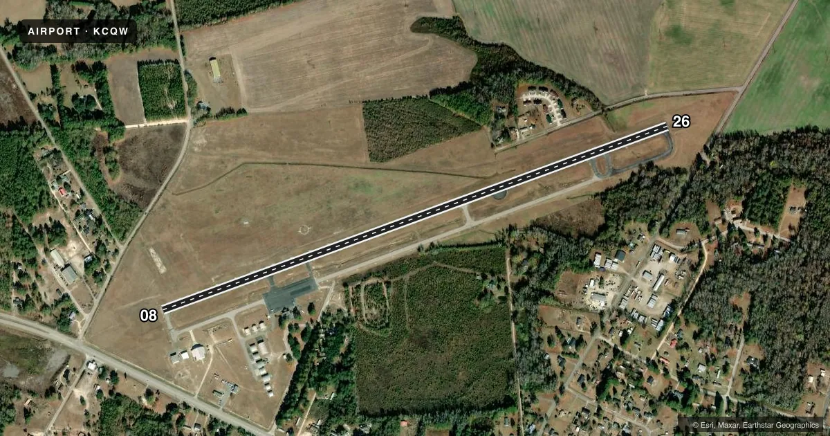
Runways & pattern
Full pagePattern entry · RWY 08
LEFT TRAFFICRunway end performance
| End | TORA | TODA | ASDA | LDA | VGSI | Approach lights | Obstruction |
|---|---|---|---|---|---|---|---|
| 08 | — | — | — | — | — | — | 46', tree, 906' from thr, 157' R of cntrln, slope 15 |
| 26 | — | — | — | — | — | — | 22', pole, 493' from thr, 187' R of cntrln, slope 13 |
Declared distances in feet. TORA = takeoff run available, TODA = takeoff distance, ASDA = accelerate-stop, LDA = landing distance.
Airport sketch
Runways drawn to scale from FAA survey coordinates, rendered over satellite imagery. Not for navigation.
Approaches & charts
Services on the field
Fuel grades, oxygen, maintenance, ramp storage and lighting — as declared to the FAA by the airport operator.
Fuel & services
- Fuel
- 100LLA
- Oxygen (bottled)
- Not available
- Oxygen (bulk)
- Not available
- Airframe repair
- Major
- Power plant repair
- Major
- Other services
- AVNCS,INSTR
Ramp & ground
- Transient storage
- Tie-down
- Landing fee
- No fee published
- Customs
- Not available
- Lighting schedule
- SEE RMK
- Beacon schedule
- SS-SR
- Beacon
- White / Green (civil land)(WG)
- Wind indicator
- Lighted
- Segmented circle
- Yes
Fuel & FBOs
Cheapest 100LL and Jet A on the field and nearby. Always confirm with the FBO before taxi.
Airport notes
Surface conditions, obstructions, local procedures, lighting outages and other notes published with each FAA cycle.
General notes
- FOR CD CTC FLORENCE APCH AT 843-665-0632, WHEN APCH CLSD CTC JACKSONVILLE ARTCC AT 904-845-1592.
Lighting notes
- ACTVT REILS RWY 08 & 26; MIRL RWY 08/26; AND WND CONE LGT - CTAF.
VFR map & nearby airports
VFR sectional. Tap any ICAO chip to open that airport.
Key facts · KCQW
Answer card- ICAO
- KCQW
- Name
- CHERAW MUNI/LYNCH BELLINGER FLD
- Location
- CHERAW, SOUTH CAROLINA
- Elevation
- 238.7 ft MSL
- Traffic pattern altitude
- 1,238.7 ft MSL (1,000 AGL)
- Control tower
- Non-towered (use CTAF)
- Total runways
- 1
- Longest runway
- 08/26 · 5,000 ft
- Published ILS approaches
- 0
- Published frequencies
- 4
- Magnetic variation
- 8°
- Current flight rules
- MVFR
- Current wind
- 000° at 0 kt
- Favored runway now
- –
Cheraw Muni/Lynch Bellinger Fld sits in Cheraw, South Carolina. Field elevation is 238.7 ft MSL. The airport has one runway. Runway 08/26 is 5,000 ft asphalt, which is the longest runway on the field. There is no control tower. Pattern altitude is not published, so use the standard 1,000 ft AGL for light piston traffic unless ATC or the Chart Supplement says otherwise.
No ILS approaches are published here. For clearance delivery, contact Florence Approach at 843-665-0632. When Approach is closed, Jacksonville ARTCC handles it at 904-845-1592. CTAF and UNICOM are both 122.8. Hall's Aviation is on the field. It carries 100LL and Jet A. The runway lighting is active on 08 and 26. Medium intensity runway lights are also on 08 and 26. The wind cone light is tied to the CTAF frequency. A power pole near runway 26 is marked and lighted, so keep that in mind on arrival and departure.
For a first-time arrival, the main items are the non-towered setup, the published obstacle near 26 and the lack of ILS. Check the current FAA Chart Supplement for any updated remarks before you go.