METAR & TAF 9W9
9W9 does not publish a METAR.
Showing the nearest reporting station: KBBP (MARLBORO COUNTY JETPORT/H E AVENT FLD) · 10.4 NM away. Conditions at 9W9 may differ.
METAR · KBBP
Observed 06:55Z
KBBP 270655Z AUTO 00000KT 4SM BR CLR 22/22 A2986 RMK AO2
- Wind
- 000° @ 0 kt
- Visibility
- 4 SM
- Temp / Dew
- 22°C / 22°C
- Altimeter
- 29.86 inHg
- Clouds
- CLR
- Density alt
- 1,153 ft
- Ceiling
- Unlimited
- Rules
- MVFR
Airport info & contacts
Manager on record, flight service, ARTCC, attendance schedule and pattern altitude — published by the FAA and refreshed every 28 days.
Location
- From city
- 2 NM SE
- VFR sectional
- CHARLOTTE
- Pattern altitude
- 600 ft AGL · 792 ft MSL
- ARTCC
- ZJX · JACKSONVILLE
- NOTAM facility
- AND (NOTAM-D)
Airport manager
- Name
- KEN HANKE
- Phone
- 843-586-9225
- Address
- PO BOX 422, CLIO SC 29525
Flight service · Hours
- FSS AND
- ANDERSON1-800-WX-BRIEF
- Attendance
- MON-FRI · 0800-DUSK
- SAT · 0800-1200
Frequencies
Tap any row to copy the frequency to your clipboard.
Runways & pattern
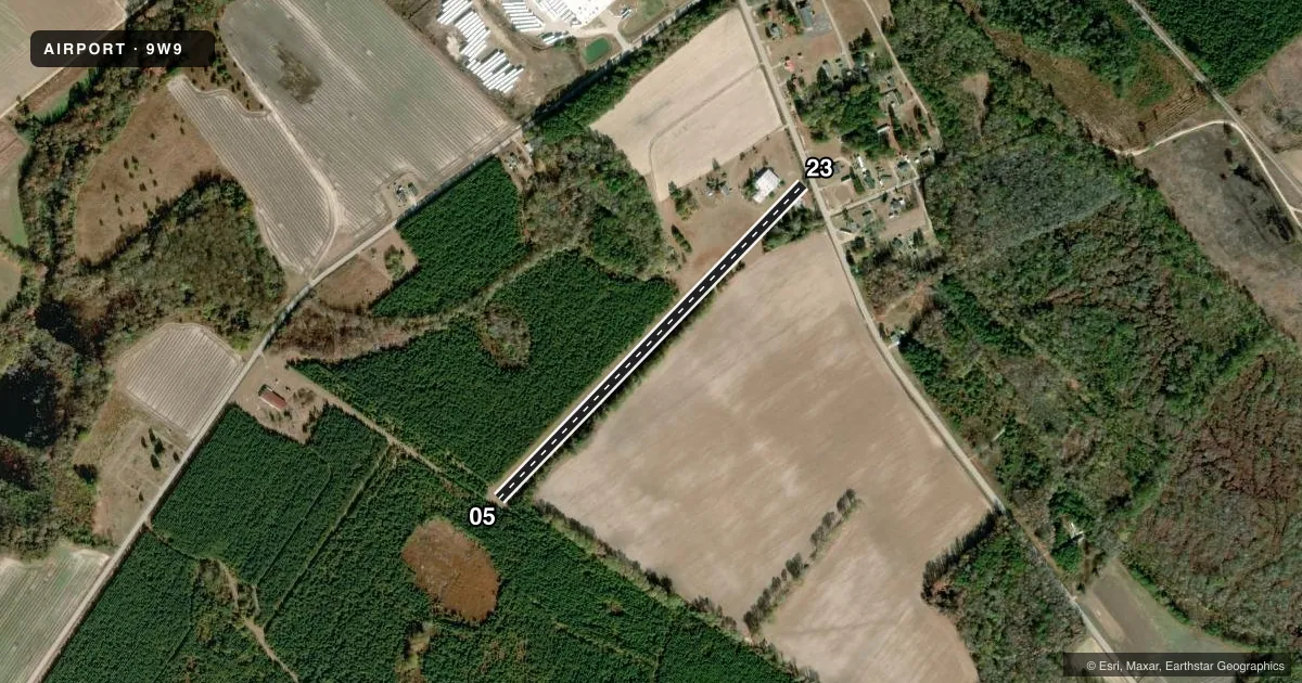
Full pagePattern entry · RWY 05
LEFT TRAFFICAirport sketch
Runways drawn to scale from FAA survey coordinates, rendered over satellite imagery. Not for navigation.
Approaches & charts
Services on the field
Fuel grades, oxygen, maintenance, ramp storage and lighting — as declared to the FAA by the airport operator.
Fuel & services
- Fuel
- Not available
- Oxygen (bottled)
- Not available
- Oxygen (bulk)
- Not available
- Airframe repair
- Major
- Power plant repair
- Major
- Other services
- AGRI
Ramp & ground
- Transient storage
- Tie-down
- Landing fee
- No fee published
- Customs
- Not available
- Wind indicator
- Yes
- Segmented circle
- No
Fuel & FBOs
Cheapest 100LL and Jet A on the field and nearby. Always confirm with the FBO before taxi.
Airport notes
Surface conditions, obstructions, local procedures, lighting outages and other notes published with each FAA cycle.
General notes
- RWY 23 100 FT R OF CNTRLN HGR & OFFICE AREA & TANKS 100 FT L 0 FT FM THR & CONCRETE BLDG 125 FT R 0-100 FT FM THR.
- FOR CD CTC FLORENCE APCH AT 843-665-0632, WHEN APCH CLSD CTC JACKSONVILLE ARTCC AT 904-845-1592.
- RWY WIDTH IS 105 FT DUE TO TREE ENCROACHMENT.
- NO THRS ARE MKD.
Other notes
- THIS AIRPORT HAS BEEN SURVEYED BY THE NATIONAL GEODETIC SURVEY.
- VFR USE ONLY.
- 05/23TALL GRASS.
VFR map & nearby airports
VFR sectional. Tap any ICAO chip to open that airport.
Key facts · 9W9
Answer card- ICAO
- 9W9
- Name
- CLIO CROP CARE
- Location
- CLIO, SOUTH CAROLINA
- Elevation
- 192.3 ft MSL
- Traffic pattern altitude
- 792.3 ft MSL (600 AGL)
- Control tower
- Non-towered (use CTAF)
- Total runways
- 1
- Longest runway
- 05/23 · 2,598 ft
- Published ILS approaches
- 0
- Published frequencies
- 1
- Magnetic variation
- 6°
- Current flight rules
- MVFR
- Current wind
- 000° at 0 kt
- Favored runway now
- –
Clio Crop Care Airport (9W9) is in Clio, South Carolina. Field elevation is 192.3 ft MSL. The airport has one runway, 05/23, which is 2,598 ft long and surfaced with turf. The published pattern altitude is 600 ft AGL, or 792.3 ft MSL. There is no control tower. CTAF is 122.9.
No ILS approaches are published here. The field is for VFR use only. That matters here because the runway surface is listed as tall grass. The published remarks also note tree encroachment, which has reduced the runway width to 105 feet. No thresholds are marked. Runway 23 has nearby hangar, office and tank obstacles close to the runway environment. First-time pilots should plan for a simple, visual arrival and pay close attention to the runway condition and the published obstacles.
There are no on-field FBOs listed. If you need fuel or other services, contact the airport operator directly before departure or call the field on CTAF for current availability. For clearance delivery, the Chart Supplement directs pilots to Florence Approach at 843-665-0632. When Approach is closed, contact Jacksonville ARTCC at 904-845-1592.