METAR & TAF KDLC
KDLC does not publish a METAR.
Showing the nearest reporting station: KMAO (MARION COUNTY) · 16.2 NM away. Conditions at KDLC may differ.
METAR · KMAO
Observed 10:35Z
KMAO 271035Z AUTO 00000KT 10SM BKN034 21/19 A2986 RMK AO2
- Wind
- 000° @ 0 kt
- Visibility
- 10 SM
- Temp / Dew
- 21°C / 19°C
- Altimeter
- 29.86 inHg
- Clouds
- BKN
- Density alt
- 959 ft
- Ceiling
- 3,400 ft AGL
- Rules
- VFR
Airport info & contacts
Manager on record, flight service, ARTCC, attendance schedule and pattern altitude — published by the FAA and refreshed every 28 days.
Location
- From city
- 3 NM N
- VFR sectional
- CHARLOTTE
- ARTCC
- ZJX · JACKSONVILLE
- NOTAM facility
- AND (NOTAM-D)
Airport manager
- Name
- TIM HARPER
- Phone
- 843-845-8529
- Address
- PO BOX 449, DILLON SC 29536
Flight service · Hours
- FSS AND
- ANDERSON1-800-WX-BRIEF
- Attendance
- Unattended
Frequencies
Tap any row to copy the frequency to your clipboard.
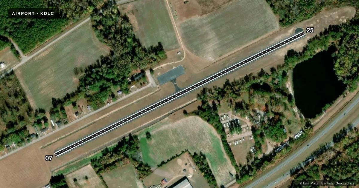
Runways & pattern
Full pagePattern entry · RWY 07
LEFT TRAFFICRunway end performance
| End | TORA | TODA | ASDA | LDA | VGSI | Approach lights | Obstruction |
|---|---|---|---|---|---|---|---|
| 07 | — | — | — | — | — | — | 44', pole, 773' from thr, 258' R of cntrln, slope 12 |
| 25 | — | — | — | — | — | — | 52', tree, 302' from thr, 135' R of cntrln, slope 1 |
Declared distances in feet. TORA = takeoff run available, TODA = takeoff distance, ASDA = accelerate-stop, LDA = landing distance.
Airport sketch
Runways drawn to scale from FAA survey coordinates, rendered over satellite imagery. Not for navigation.
Approaches & charts
Services on the field
Fuel grades, oxygen, maintenance, ramp storage and lighting — as declared to the FAA by the airport operator.
Fuel & services
- Fuel
- Not available
- Oxygen (bottled)
- Not available
- Oxygen (bulk)
- Not available
- Airframe repair
- Not available
- Power plant repair
- Not available
Ramp & ground
- Transient storage
- Tie-down
- Landing fee
- No fee published
- Customs
- Not available
- Lighting schedule
- SS-SR
- Beacon schedule
- SS-SR
- Beacon
- White / Green (civil land)(WG)
- Wind indicator
- Yes
- Segmented circle
- Yes
Fuel & FBOs
Cheapest 100LL and Jet A on the field and nearby. Always confirm with the FBO before taxi.
Airport notes
Surface conditions, obstructions, local procedures, lighting outages and other notes published with each FAA cycle.
General notes
- FOR CD CTC FLORENCE APCH AT 843-665-0632, WHEN APCH CLSD CTC JACKSONVILLE ARTCC AT 904-845-1592.
Approach & departure obstructions
- 25RWY 25 APCH HAS LINES OF TREES PARL TO THE RWY 135 FT BOTH SIDES OF CNTRLN.
Other notes
- THIS AIRPORT HAS BEEN SURVEYED BY THE NATIONAL GEODETIC SURVEY.
VFR map & nearby airports
VFR sectional. Tap any ICAO chip to open that airport.
Key facts · KDLC
Answer card- ICAO
- KDLC
- Name
- DILLON COUNTY
- Location
- DILLON, SOUTH CAROLINA
- Elevation
- 133.1 ft MSL
- Traffic pattern altitude
- 1,133.1 ft MSL (1,000 AGL)
- Control tower
- Non-towered (use CTAF)
- Total runways
- 1
- Longest runway
- 07/25 · 3,000 ft
- Published ILS approaches
- 0
- Published frequencies
- 3
- Magnetic variation
- 6°
- Current flight rules
- VFR
- Current wind
- 000° at 0 kt
- Favored runway now
- –
Dillon County Airport (KDLC) sits in Dillon, South Carolina. The field elevation is 133.1 ft MSL. It has one runway, 07/25, which is 3,000 ft long and asphalt. There is no control tower. Pattern altitude is not published, so plan on the standard 1,000 ft AGL for light piston traffic unless the current Chart Supplement says otherwise.
No ILS approaches are published here. The airport uses CTAF 122.9. Florence Approach handles clearance delivery on 118.6 and 341.7. If approach is closed, contact Jacksonville ARTCC directly at the number listed in the Chart Supplement. There are no on-field FBOs listed, so verify fuel and services with the airport operator or call the field before you go.
A published remark notes trees near the Runway 25 approach. They sit parallel to the runway about 135 feet from the centerline on both sides. That is worth keeping in mind on short final, especially if you are coming in low or at night. The airport has also been surveyed by the National Geodetic Survey. For a first visit, treat this as a small non-towered field with one short runway and no published ILS. Check the current Chart Supplement for any changes before departure.