METAR & TAF KHYW
Current METAR
Observed 08:35Z
KHYW 270835Z AUTO 00000KT 5SM BR CLR 21/21 A2985 RMK AO2 LTG DSNT S
- Wind
- 000° @ 0 kt
- Visibility
- 5 SM
- Temp / Dew
- 21°C / 21°C
- Altimeter
- 29.85 inHg
- Clouds
- CLR
- Density alt
- 850 ft
- Ceiling
- Unlimited
- Rules
- MVFR
Airport info & contacts
Manager on record, flight service, ARTCC, attendance schedule and pattern altitude — published by the FAA and refreshed every 28 days.
Location
- From city
- 3 NM W
- VFR sectional
- CHARLOTTE
- ARTCC
- ZJX · JACKSONVILLE
- NOTAM facility
- AND (NOTAM-D)
Airport manager
- Name
- JUDI OLMSTEAD
- Phone
- 843-448-1580
- Address
- 1100 JETPORT RD, MYRTLE BEACH SC 29577
Flight service · Hours
- FSS AND
- ANDERSON1-800-WX-BRIEF
- Attendance
- 0900-1700
Frequencies
Tap any row to copy the frequency to your clipboard.
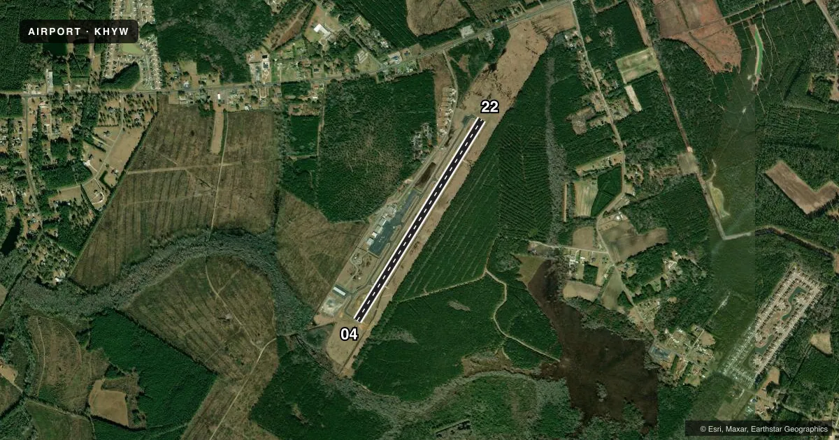
Runways & pattern
Full pagePattern entry · RWY 04
LEFT TRAFFICRunway end performance
| End | TORA | TODA | ASDA | LDA | VGSI | Approach lights | Obstruction |
|---|---|---|---|---|---|---|---|
| 04 | — | — | — | — | PAPI 4-box right(3.35°) | — | 89', tree, 1776' from thr, 220' R of cntrln, slope 17 |
| 22 | — | — | — | — | PAPI 4-box left(3°) | — | 76', tree, 2013' from thr, 449' R of cntrln, slope 23 |
Declared distances in feet. TORA = takeoff run available, TODA = takeoff distance, ASDA = accelerate-stop, LDA = landing distance.
Airport sketch
Runways drawn to scale from FAA survey coordinates, rendered over satellite imagery. Not for navigation.
Approaches & charts
Services on the field
Fuel grades, oxygen, maintenance, ramp storage and lighting — as declared to the FAA by the airport operator.
Fuel & services
- Fuel
- 100LLAA+
- Oxygen (bottled)
- Not available
- Oxygen (bulk)
- Not available
- Airframe repair
- Major
- Power plant repair
- Major
- Other services
- INSTR
Ramp & ground
- Transient storage
- Tie-down
- Landing fee
- No fee published
- Customs
- Not available
- Lighting schedule
- SEE RMK
- Beacon schedule
- SS-SR
- Beacon
- White / Green (civil land)(WG)
- Wind indicator
- Lighted
- Segmented circle
- Yes
Fuel & FBOs
Cheapest 100LL and Jet A on the field and nearby. Always confirm with the FBO before taxi.
Airport notes
Surface conditions, obstructions, local procedures, lighting outages and other notes published with each FAA cycle.
General notes
- FOR CD CTC MYRTLE BEACH APCH AT 843-477-2727 OR 843-477-2704, WHEN APCH CLSD CTC JACKSONVILLE ARTCC AT 904-845-1592.
Lighting notes
- ACTVT MIRL RWY 04/22 - CTAF.
Fuel notes
- 100LLFUEL 24 HR CREDIT CARD SVC AVBL.
VFR map & nearby airports
VFR sectional. Tap any ICAO chip to open that airport.
Key facts · KHYW
Answer card- ICAO
- KHYW
- Name
- CONWAY-HORRY COUNTY
- Location
- CONWAY, SOUTH CAROLINA
- Elevation
- 34.8 ft MSL
- Traffic pattern altitude
- 1,034.8 ft MSL (1,000 AGL)
- Control tower
- Non-towered (use CTAF)
- Total runways
- 1
- Longest runway
- 04/22 · 4,401 ft
- Published ILS approaches
- 0
- Published frequencies
- 4
- Magnetic variation
- 8°
- Current flight rules
- MVFR
- Current wind
- 000° at 0 kt
- Favored runway now
- –
Conway-Horry County Airport sits in Conway, South Carolina. Field elevation is 34.8 ft MSL. The airport has one runway, 04/22, which is 4,401 ft long. There is no control tower. The pattern altitude is not published, so use the standard 1,000 ft AGL for light piston traffic unless the current Chart Supplement says otherwise.
No ILS approaches are published here. CTAF and UNICOM are both 122.7. Approach and departure services are handled by Myrtle Beach on 127.4 and 257.95. For clearance delivery, contact Myrtle Beach Approach. If approach is closed, Jacksonville ARTCC is the backup contact listed in the remarks.
Beach Aviation Services is on the field. It carries AVGAS 100LL and Jet A. Fuel is available 24 hours with credit card service. Runway 04/22 has medium intensity lights that are activated by the CTAF. That matters for night arrivals because you will need to key the lights from the pattern or approach.
This is a low-elevation coastal airport. Density altitude can still climb on hot days, so plan performance with the summer weather in mind. Check the current Chart Supplement for any noise or curfew restrictions before flying in.