METAR & TAF KMYR
Current METAR
Observed 09:05Z
KMYR 270905Z AUTO 00000KT 10SM FEW018 24/23 A2985 RMK AO2 $
- Wind
- 000° @ 0 kt
- Visibility
- 10 SM
- Temp / Dew
- 24°C / 23°C
- Altimeter
- 29.85 inHg
- Clouds
- FEW
- Density alt
- 1,198 ft
- Ceiling
- Unlimited
- Rules
- VFR
Airport info & contacts
Manager on record, flight service, ARTCC, attendance schedule and pattern altitude — published by the FAA and refreshed every 28 days.
Location
- From city
- 3 NM SW
- VFR sectional
- CHARLOTTE
- ARTCC
- ZJX · JACKSONVILLE
- NOTAM facility
- MYR (NOTAM-D)
Airport manager
- Name
- JUDI OLMSTEAD
- Phone
- 843-448-1580
- Address
- 1100 JETPORT RD, MYRTLE BEACH SC 29577
Flight service · Hours
- FSS AND
- ANDERSON1-800-WX-BRIEF
- Attendance
- 0600-2100
Frequencies
Tap any row to copy the frequency to your clipboard.
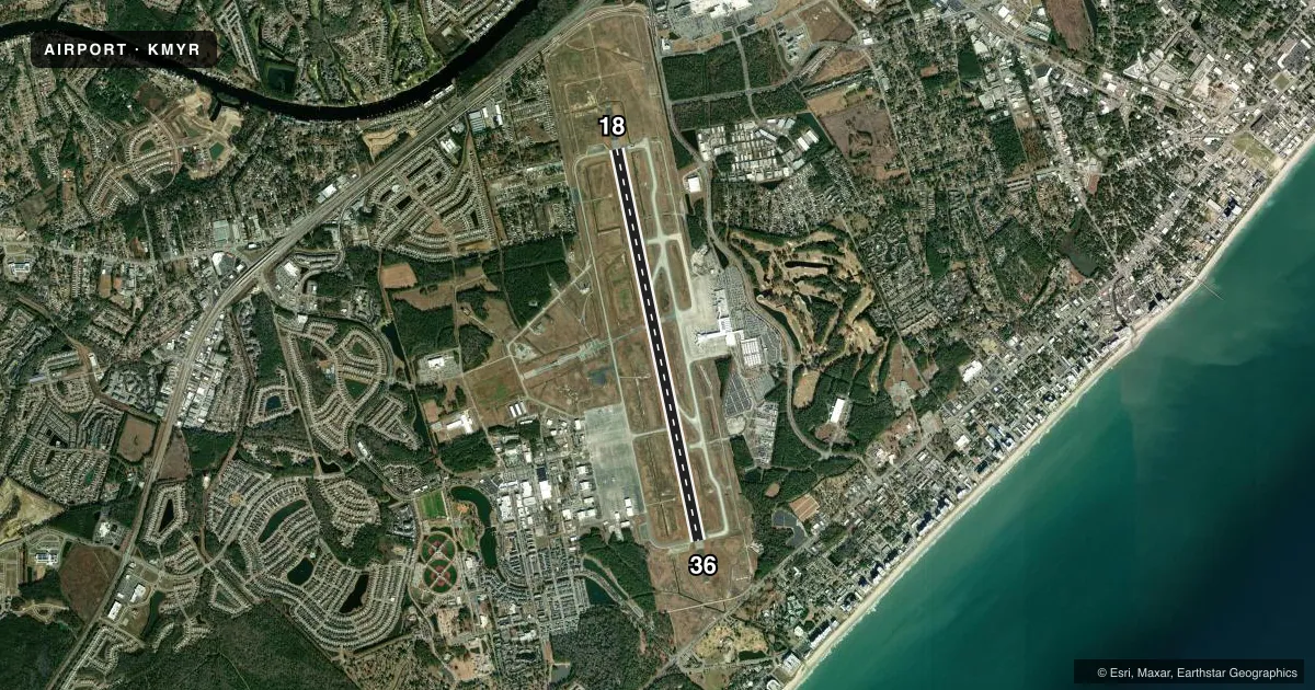
Runways & pattern
Full pagePattern entry · RWY 18
RIGHT TRAFFICRunway end performance
| End | TORA | TODA | ASDA | LDA | VGSI | Approach lights | Obstruction |
|---|---|---|---|---|---|---|---|
| 18 | — | — | — | — | PAPI 4-box left(3°) | MALSR | pline, 3000' from thr, slope 50 |
| 36 | — | — | — | — | PAPI 4-box left(3°) | MALSF | trees, 2100' from thr, slope 50 |
Declared distances in feet. TORA = takeoff run available, TODA = takeoff distance, ASDA = accelerate-stop, LDA = landing distance.
Airport sketch
Runways drawn to scale from FAA survey coordinates, rendered over satellite imagery. Not for navigation.
Approaches & charts
ILS · 2
Services on the field
Fuel grades, oxygen, maintenance, ramp storage and lighting — as declared to the FAA by the airport operator.
Fuel & services
- Fuel
- 100LLA
- Oxygen (bottled)
- Not available
- Oxygen (bulk)
- Not available
- Airframe repair
- Major
- Power plant repair
- Major
- Other services
- CHTR,INSTR,RNTL
Ramp & ground
- Transient storage
- Tie-down
- Customs
- Not available
- Lighting schedule
- SEE RMK
- Beacon schedule
- SS-SR
- Beacon
- White / Green (civil land)(WG)
- Wind indicator
- Yes
- Segmented circle
- Yes
Fuel & FBOs
Cheapest 100LL and Jet A on the field and nearby. Always confirm with the FBO before taxi.
Airport notes
Surface conditions, obstructions, local procedures, lighting outages and other notes published with each FAA cycle.
General notes
- GULLS ON & INVOF ARPT.
- APVL RQRD FOR PUSHBACK AT TRML GATES A9, A10, A11, A12, A14. CTC MYR GC 120.3; PUSH IS AT PILOT DISCRETION ALL OTR GATES; RMN CLR OF TWYS.
- CTC MYR OPS ON CTAF 128.45 PRIOR TO LNDG 2300-0600.
- MEDEVAC HEL DEPG GRAND STRAND MED CTR, SW BOUND, CTC MYR TWR ON 134.05 PRIOR TO DEP OR AS SOON AS AB.
- PILOTS CONDUCTING EFVS OPS; BE AWARE LED ALS IN USE RWY 18 & RWY 36.
- SIGHTSEEING HELS OPRG IN CLOSE PROXIMITY OF ARPT AND RWY AT OR BLW 1200 FT. HELS DEPG/ARRG PAD LCTD 700 FT SSE APCH END RWY 36. HEL RTES AND HLDG POINTS RMN CLR OF RWY.
Lighting notes
- WHEN ATCT CLSD ACTVT MALSR RWY 18, MALSF RWY 36; HIRL RWY 18/36 - CTAF.
Runway surface & condition
- 18/36PCR VALUE: 302/F/A/X/T
Other notes
- EXISTED PRIOR TO 1959.
- U.S. CUSTOMS SVC AVBL MON-FRI 0800-1700, OTR TIMES PPR & FEE CHARGED.
- MANAGERATCT MANAGER 843-238-3008, EXT 1. VANMOPPES@HORRYCOUNTY.ORG
VFR map & nearby airports
VFR sectional. Tap any ICAO chip to open that airport.
Key facts · KMYR
Answer card- ICAO
- KMYR
- Name
- MYRTLE BEACH INTL
- Location
- MYRTLE BEACH, SOUTH CAROLINA
- Elevation
- 25 ft MSL
- Traffic pattern altitude
- 1,025 ft MSL (1,000 AGL)
- Control tower
- Towered · 0600-2300
- Total runways
- 1
- Longest runway
- 18/36 · 9,503 ft
- Published ILS approaches
- 2
- Published frequencies
- 19
- Magnetic variation
- 9°
- Current flight rules
- VFR
- Current wind
- 000° at 0 kt
- Favored runway now
- –
MYRTLE BEACH INTL sits in Myrtle Beach, South Carolina. Field elevation is 25 ft MSL. The airport has one runway, 18/36, which is 9,503 ft long. The tower is open daily from 0600 to 2300. Two ILS approaches are published, one for runway 18 and one for runway 36. Pattern altitude is not published. Use 1,000 ft AGL for light piston traffic unless the current Chart Supplement says otherwise. That puts the pattern at 1,025 ft MSL here.
Beach Aviation Services is on the field. It carries 100LL, Jet A and Jet A Prist. The airport sits in Class C airspace, so expect standard tower and approach coordination. The field also has helicopter activity close to the airport and runway. Published remarks say sightseeing helicopters operate at or below 1,200 ft and use a pad 700 ft south-southeast of the approach end of runway 36. Gulls are also noted in the area, so bird activity is part of the normal picture.
If you plan to arrive between 2300 and 0600, contact Myrtle Beach operations on CTAF 128.45 before landing. Customs service is available Monday through Friday from 0800 to 1700. Other times need prior permission. The airport has a long paved runway, so performance is usually not the limiting factor. Traffic and coordination are the bigger items here.