METAR & TAF 5J9
5J9 does not publish a METAR.
Showing the nearest reporting station: KCPC (COLUMBUS COUNTY RGNL) · 13.3 NM away. Conditions at 5J9 may differ.
METAR · KCPC
Observed 12:55Z
KCPC 251255Z AUTO 00000KT 10SM CLR 24/20 A3010 RMK AO2 T02440204
- Wind
- 000° @ 0 kt
- Visibility
- 10 SM
- Temp / Dew
- 24°C / 20°C
- Altimeter
- 30.10 inHg
- Clouds
- CLR
- Density alt
- 980 ft
- Ceiling
- Unlimited
- Rules
- VFR
Airport info & contacts
Manager on record, flight service, ARTCC, attendance schedule and pattern altitude — published by the FAA and refreshed every 28 days.
Location
- From city
- 3 NM NE
- VFR sectional
- CHARLOTTE
- ARTCC
- ZJX · JACKSONVILLE
- NOTAM facility
- AND (NOTAM-D)
Airport manager
- Name
- JUDI OLMSTEAD
- Phone
- 843-448-1580
- Address
- 1100 JETPORT RD, MYRTLE BEACH SC 29577
Flight service · Hours
- FSS AND
- ANDERSON1-800-WX-BRIEF
- Attendance
- Unattended
Frequencies
Tap any row to copy the frequency to your clipboard.
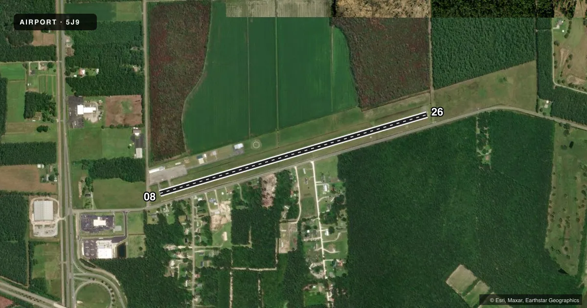
Runways & pattern
Full pagePattern entry · RWY 08
LEFT TRAFFICRunway end performance
| End | TORA | TODA | ASDA | LDA | VGSI | Approach lights | Obstruction |
|---|---|---|---|---|---|---|---|
| 08 | — | — | — | — | — | — | 17', road, 200' from thr, 0' R of cntrln, slope 1 |
| 26 | — | — | — | — | S2L 2-box left(3.5°) | — | 86', trees, 1759' from thr, 10' R of cntrln, slope 18 |
Declared distances in feet. TORA = takeoff run available, TODA = takeoff distance, ASDA = accelerate-stop, LDA = landing distance.
Airport sketch
Runways drawn to scale from FAA survey coordinates, rendered over satellite imagery. Not for navigation.
Approaches & charts
Services on the field
Fuel grades, oxygen, maintenance, ramp storage and lighting — as declared to the FAA by the airport operator.
Fuel & services
- Fuel
- Not available
- Oxygen (bottled)
- Not available
- Oxygen (bulk)
- Not available
- Airframe repair
- Not available
- Power plant repair
- Not available
Ramp & ground
- Transient storage
- Tie-down
- Landing fee
- No fee published
- Customs
- Not available
- Beacon schedule
- SS-SR
- Beacon
- White / Green (civil land)(WG)
- Wind indicator
- Lighted
- Segmented circle
- Yes
Fuel & FBOs
Cheapest 100LL and Jet A on the field and nearby. Always confirm with the FBO before taxi.
Airport notes
Surface conditions, obstructions, local procedures, lighting outages and other notes published with each FAA cycle.
General notes
- 30 FT POWER LINE 180 FT SOUTH OF RWY 8-26.
- BIRDS ON AND INVOF ARPT.
- FOR CD CTC MYRTLE BEACH APCH AT 843-477-2727 OR 843-477-2704, WHEN APCH CLSD CTC JACKSONVILLE ARTCC AT 904-845-1592.
Approach & departure obstructions
- 08RWY 08 ROADWAY AND 50FT TREES 150' TO 175' R;DIST 0 TO 200 FT FROM RWY. AIRCRAFT ACTIVITY APRON 150FT R, DIST 0 TO 125' FROM RWY.
- 08RWY 08 ST-IN APPR 21:1 TO DSP THR DUE TO 17' ROADWAY BOTH SIDES OF CENTERLINE; 358' FROM DSP THR. 50FT TREES 175' R AND AIRCRAFT ACTIVITY APRON 150' L LOCATED PARALLEL TO RWY.
Other notes
- THIS AIRPORT HAS BEEN SURVEYED BY THE NATIONAL GEODETIC SURVEY.
- VFR USE ONLY
VFR map & nearby airports
VFR sectional. Tap any ICAO chip to open that airport.
Key facts · 5J9
Answer card- ICAO
- 5J9
- Name
- TWIN CITY
- Location
- LORIS, SOUTH CAROLINA
- Elevation
- 99.3 ft MSL
- Traffic pattern altitude
- 1,099.3 ft MSL (1,000 AGL)
- Control tower
- Non-towered (use CTAF)
- Total runways
- 1
- Longest runway
- 08/26 · 3,694 ft
- Published ILS approaches
- 0
- Published frequencies
- 3
- Magnetic variation
- 8°
- Current flight rules
- VFR
- Current wind
- 000° at 0 kt
- Favored runway now
- –
Twin City Airport is in Loris, South Carolina. The field elevation is 99.3 ft MSL. It has one runway. Runway 08/26 is 3,694 ft long with asphalt pavement. There is no control tower, so use CTAF 122.9 and stay sharp on the radio. No ILS approaches are published here. The pattern altitude is not published, so use the standard 1,000 ft AGL for light piston operations unless the current Chart Supplement says otherwise.
This is a VFR-only airport. The published remarks call out several things that matter on short final. Runway 08 has a displaced threshold. The straight-in path to 08 has nearby roadway and tree obstructions. There is also a 30-foot power line south of the runway. Birds are reported on and near the airport, so keep a close scan on departure and in the pattern. Clearance delivery is handled by Myrtle Beach Approach when it is open. If approach is closed, contact Jacksonville ARTCC. No on-field FBOs are listed, so verify services with the airport operator or the FBO directly by phone before you go.