METAR & TAF KEYF
Current METAR
Observed 03:35Z
KEYF 120335Z AUTO 21007KT 10SM CLR 27/21 A2994 RMK AO2 T02670210
- Wind
- 210° @ 7 kt
- Visibility
- 10 SM
- Temp / Dew
- 27°C / 21°C
- Altimeter
- 29.94 inHg
- Clouds
- CLR
- Density alt
- 1,578 ft
- Ceiling
- Unlimited
- Rules
- VFR
Airport info & contacts
Manager on record, flight service, ARTCC, attendance schedule and pattern altitude — published by the FAA and refreshed every 28 days.
Location
- From city
- 2 NM SE
- VFR sectional
- CHARLOTTE
- ARTCC
- ZDC · WASHINGTON
- NOTAM facility
- EYF (NOTAM-D)
Airport manager
- Name
- KEN HADAWAY
- Phone
- 910-862-4522
- Address
- 466 AIRPORT RD, ELIZABETHTOWN NC 28337
Flight service · Hours
- FSS RDU
- RALEIGH1-800-WX-BRIEF
- Attendance
- MON-SAT · 0800-1700
Frequencies
Tap any row to copy the frequency to your clipboard.
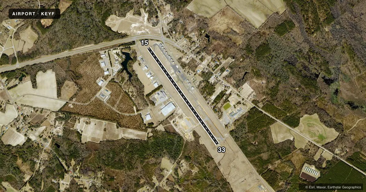
Runways & pattern
Full pagePattern entry · RWY 15
LEFT TRAFFICRunway end performance
| End | TORA | TODA | ASDA | LDA | VGSI | Approach lights | Obstruction |
|---|---|---|---|---|---|---|---|
| 15 | — | — | — | — | PAPI 2-box left(3°) | — | 6', fence, 248' from thr, 192' R of cntrln, slope 8 |
| 33 | — | — | — | — | PAPI 2-box left(3°) | — | 103', trees, 3980' from thr, 390' R of cntrln, slope 36 |
Declared distances in feet. TORA = takeoff run available, TODA = takeoff distance, ASDA = accelerate-stop, LDA = landing distance.
Airport sketch
Runways drawn to scale from FAA survey coordinates, rendered over satellite imagery. Not for navigation.
Approaches & charts
Services on the field
Fuel grades, oxygen, maintenance, ramp storage and lighting — as declared to the FAA by the airport operator.
Fuel & services
- Fuel
- 100LLA1+
- Oxygen (bottled)
- Not available
- Oxygen (bulk)
- Not available
- Airframe repair
- Minor
- Power plant repair
- Minor
- Other services
- AMB,INSTR,RNTL,SALES
Ramp & ground
- Transient storage
- Tie-down
- Hangar
- Landing fee
- No fee published
- Lighting schedule
- SEE RMK
- Beacon schedule
- SS-SR
- Beacon
- White / Green (civil land)(WG)
- Wind indicator
- Lighted
- Segmented circle
- Yes
Fuel & FBOs
Cheapest 100LL and Jet A on the field and nearby. Always confirm with the FBO before taxi.
Airport notes
Surface conditions, obstructions, local procedures, lighting outages and other notes published with each FAA cycle.
General notes
- DEER & BIRDS ON AND INVOF ARPT.
- LOW LEVEL MIL ACT INVOF ARPT.
- BCN OBSCURED BY TREES TO THE EAST.
- FOR CD CTC WASHINGTON ARTCC AT 703-771-3587.
- 10 FT DITCH ALONG LEFT SIDE TWY A TOWARD RWY 33.
Lighting notes
- ACTVT REIL RWY 15 & 33 - CTAF. PAPI RWY 15 & 33 ON DAWN TO 0100 OR WHEN MIRL RWY 15/33 ON. AFTER 0100 ACTVT MIRL RWY 15/33 AND TWY - CTAF.
Fuel notes
- 100LLSELF SVC FUEL AVBL 24 HRS WITH CREDIT CARD.
Approach & departure obstructions
- 15HAS 6 FT FENCE 0 TO 200 FT FM THR OFFSET 250 FT L OF CNTRLN.
Other notes
- VFR ONLY.
- 1FOR SVC AFTER HRS & EMERG CALL 910-862-4522. UNATNDD THANKSGIVING, CHRISTMAS, AND NEW YEARS DAY.
VFR map & nearby airports
VFR sectional. Tap any ICAO chip to open that airport.
Key facts · KEYF
Answer card- ICAO
- KEYF
- Name
- CURTIS L BROWN JR FLD
- Location
- ELIZABETHTOWN, NORTH CAROLINA
- Elevation
- 131.3 ft MSL
- Traffic pattern altitude
- 1,131.3 ft MSL (1,000 AGL)
- Control tower
- Non-towered (use CTAF)
- Total runways
- 1
- Longest runway
- 15/33 · 5,006 ft
- Published ILS approaches
- 0
- Published frequencies
- 4
- Magnetic variation
- 8°
- Current flight rules
- VFR
- Current wind
- 210° at 7 kt
- Favored runway now
- RWY 15
Curtis L Brown Jr Fld (KEYF) sits in Elizabethtown, North Carolina. Field elevation is 131.3 ft MSL. The airport has one runway. Runway 15/33 is 5,006 ft long and paved with asphalt. There is no control tower, so expect CTAF self-announce operations on 122.8. No ILS approaches are published here, so plan for VFR only. Pattern altitude is not published. Use the standard 1,000 ft AGL for light piston traffic unless the current Chart Supplement says otherwise.
Sovereign Aerospace is on the field. It carries 100LL and Jet A Prist. Self-serve 100LL is available 24 hours with credit card. The airport is unattended on Thanksgiving, Christmas and New Year's Day. For after-hours service or emergencies, the published number is 910-862-4522.
A few local items matter for the brief. Runway end identifier lights on 15 and 33 are CTAF-activated. The PAPI on both ends works from dawn to 0100 or when the medium intensity runway lights are on. After 0100, the runway lights and taxiways are activated by CTAF. Runway 15 has a fence near the departure end, offset left of centerline. There is also low level military activity in the area. Deer, birds and a tree-obscured beacon to the east are worth keeping in mind. Clearance delivery is handled through Washington ARTCC at 703-771-3587.