METAR & TAF KACZ
Current METAR
Observed 03:55Z
KACZ 270355Z AUTO 00000KT 10SM BKN080 24/22 A2990 RMK AO2 T02360219
- Wind
- 000° @ 0 kt
- Visibility
- 10 SM
- Temp / Dew
- 24°C / 22°C
- Altimeter
- 29.90 inHg
- Clouds
- BKN
- Density alt
- 1,152 ft
- Ceiling
- 8,000 ft AGL
- Rules
- VFR
Airport info & contacts
Manager on record, flight service, ARTCC, attendance schedule and pattern altitude — published by the FAA and refreshed every 28 days.
Location
- From city
- 1 NM SW
- VFR sectional
- CHARLOTTE
- ARTCC
- ZDC · WASHINGTON
- NOTAM facility
- RDU (NOTAM-D)
Airport manager
- Name
- BEN JONES
- Phone
- 910-285-6642
- Address
- 250 HENDERSON FIELD ROAD, WALLACE NC 28466
Flight service · Hours
- FSS RDU
- RALEIGH1-800-WX-BRIEF
- Attendance
- MON-SAT · 0800-1700
- SUN · 1300-1800
Frequencies
Tap any row to copy the frequency to your clipboard.
Runways & pattern
Full pagePattern entry · RWY 09
LEFT TRAFFICRunway end performance
| End | TORA | TODA | ASDA | LDA | VGSI | Approach lights | Obstruction |
|---|---|---|---|---|---|---|---|
| 09 | — | — | — | — | PAPI 2-box left(3.13°) | — | — |
| 27 | — | — | — | — | PAPI 2-box left(3.53°) | — | — |
Declared distances in feet. TORA = takeoff run available, TODA = takeoff distance, ASDA = accelerate-stop, LDA = landing distance.
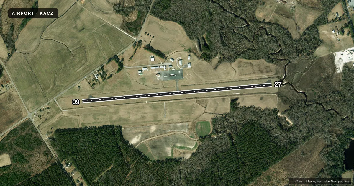
Airport sketch
Runways drawn to scale from FAA survey coordinates, rendered over satellite imagery. Not for navigation.
Approaches & charts
Services on the field
Fuel grades, oxygen, maintenance, ramp storage and lighting — as declared to the FAA by the airport operator.
Fuel & services
- Fuel
- 100LLA1+
- Oxygen (bottled)
- Not available
- Oxygen (bulk)
- Not available
- Airframe repair
- Major
- Power plant repair
- Major
- Other services
- INSTR,RNTL
Ramp & ground
- Transient storage
- Tie-down
- Landing fee
- No fee published
- Customs
- Not available
- Lighting schedule
- SEE RMK
- Beacon schedule
- SS-SR
- Beacon
- White / Green (civil land)(WG)
- Wind indicator
- Lighted
- Segmented circle
- Yes
Fuel & FBOs
Cheapest 100LL and Jet A on the field and nearby. Always confirm with the FBO before taxi.
Airport notes
Surface conditions, obstructions, local procedures, lighting outages and other notes published with each FAA cycle.
General notes
- 5 FT DITCH 135 FT RIGHT OF CNTRLN RWY 09.
- 7 FT DITCH 140 FT LEFT OF CNTRLN RWY 27.
- RWY 27 SAFETY AREA HAS 20 FT DEPRESSIONS/CREEK 160 FT FR THR BOTH SIDES CNTRLN.
- MIL ACFT LIMIT DLA ON RWY TO AVOID DAMAGE TO RWY SURFACES.
- NOISE ABATEMENT PROCS IN EFF, CALL AMGR 910-271-8955.
- WALLACE-PENDER ARPT CLSD TO TOUCH & GO/PRACTICE APCHS 2100-0600 LCL DLY.
- ARPT CLSD TO MIL ACFT EXCEPT 1 HR PPR.
- FOR CD CTC WILMINGTON APCH AT 910-815-4676, OR WHEN APCH CLSD CTC WASHINGTON ARTCC AT 703-771-3587.
Lighting notes
- ACTVT MIRLS RWY 09/27- CTAF. PAPIS OPR CONSLY.
Fuel notes
- 100LL24 HR SELF SVC FUEL WITH CREDIT CARD.
Approach & departure obstructions
- 09APCH SLOPE 27:1 TO DSPLCD THLD.
- 27APCH SLOPE 25:1 TO DSPLCD THLD.
Other notes
- 124 HR ACES TO PILOTS LOUNGE.
- MANAGERFBO (DAY): 910-285-6642. AFT HRS: 910-271-8955. ALTN (POLICE DEPT): 910-285-2126.
VFR map & nearby airports
VFR sectional. Tap any ICAO chip to open that airport.
Key facts · KACZ
Answer card- ICAO
- KACZ
- Name
- WALLACE-PENDER
- Location
- WALLACE, NORTH CAROLINA
- Elevation
- 38.1 ft MSL
- Traffic pattern altitude
- 1,038.1 ft MSL (1,000 AGL)
- Control tower
- Non-towered (use CTAF)
- Total runways
- 1
- Longest runway
- 09/27 · 4,153 ft
- Published ILS approaches
- 0
- Published frequencies
- 4
- Magnetic variation
- 9°
- Current flight rules
- VFR
- Current wind
- 000° at 0 kt
- Favored runway now
- –
Wallace-Pender Airport (KACZ) sits near Wallace, North Carolina. Field elevation is 38.1 ft MSL. The airport has one runway. Runway 09/27 is 4,153 ft long, which is the longest runway on the field. There is no control tower. Pattern altitude is not published, so use the standard 1,000 ft AGL for light piston operations unless the current Chart Supplement says otherwise.
No ILS approaches are published here. CTAF and UNICOM are both 122.8. Wilmington Approach handles approach and departure services on 135.75 and 317.425. The on-field FBO is Wallace-Pender Airport. It carries 100LL and Jet A Prist. The field also has 24-hour self-serve 100LL with credit card access.
First-time arrivals should pay close attention to the published remarks. Noise abatement procedures are in effect. Touch-and-goes and practice approaches are closed from 2100 to 0600 local daily. Runway 09 has a ditch 135 ft right of centerline. Runway 27 has depressions in the safety area and a creek near the threshold. There are also ditch and slope notes on both runway ends. If you need current clearance or operational details, call the airport manager or Wilmington Approach before you go.