METAR & TAF KDPL
Current METAR
Observed 14:55Z
KDPL 271455Z AUTO 21003KT 7SM SCT023 BKN028 BKN035 29/24 A2987 RMK AO2
- Wind
- 210° @ 3 kt
- Visibility
- 7 SM
- Temp / Dew
- 29°C / 24°C
- Altimeter
- 29.87 inHg
- Clouds
- BKN
- Density alt
- 1,911 ft
- Ceiling
- 2,800 ft AGL
- Rules
- MVFR
Airport info & contacts
Manager on record, flight service, ARTCC, attendance schedule and pattern altitude — published by the FAA and refreshed every 28 days.
Location
- From city
- 2 NM NW
- VFR sectional
- CHARLOTTE
- ARTCC
- ZDC · WASHINGTON
- NOTAM facility
- DPL (NOTAM-D)
Airport manager
- Name
- JOSH RAYNOR
- Phone
- 910-296-2188
- Address
- 260 AIRPORT ROAD, KENANSVILLE NC 28349
Flight service · Hours
- FSS RDU
- RALEIGH1-800-WX-BRIEF
- Attendance
- SUN · 1300-1800
- MON-FRI · 0700-1800
- SAT · 0800-1800
Frequencies
Tap any row to copy the frequency to your clipboard.
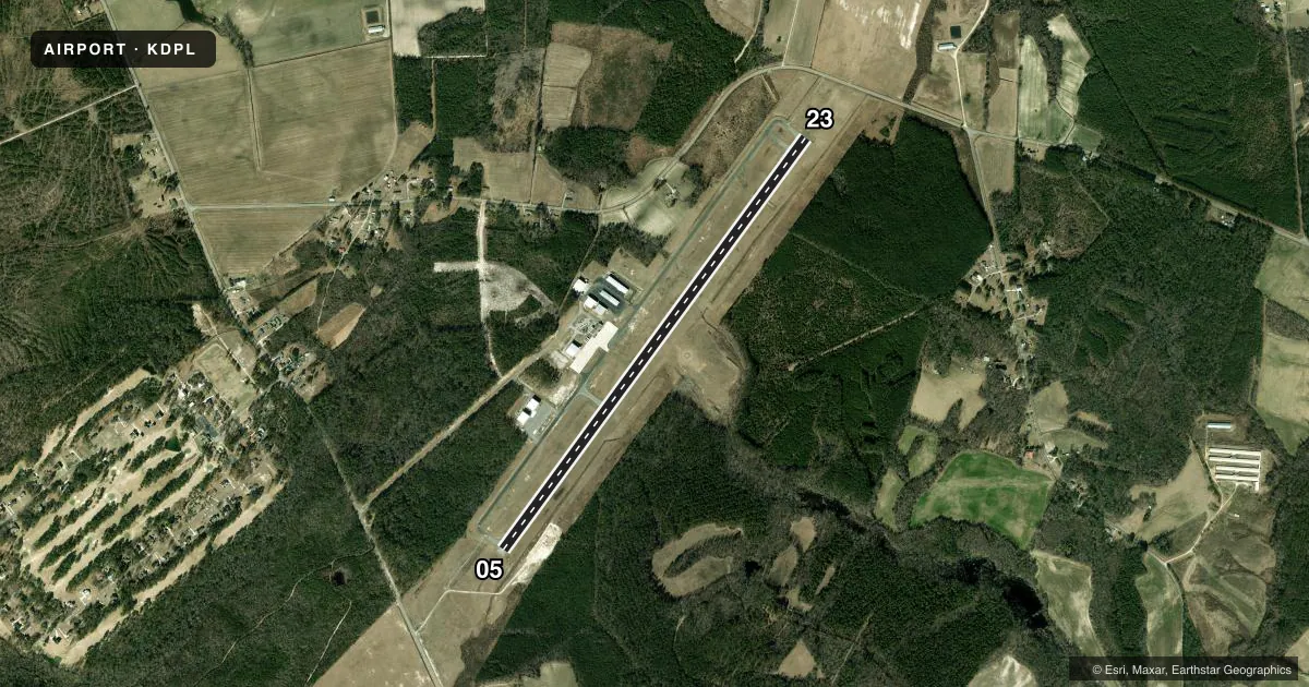
Runways & pattern
Full pagePattern entry · RWY 23
LEFT TRAFFICRunway end performance
| End | TORA | TODA | ASDA | LDA | VGSI | Approach lights | Obstruction |
|---|---|---|---|---|---|---|---|
| 05 | — | — | — | — | PAPI 4-box left(3°) | — | 13', trees, 309' from thr, 243' R of cntrln, slope 8 |
| 23 | — | — | — | — | PAPI 4-box left(3°) | — | 79', trees, 2951' from thr, 28' R of cntrln, slope 34 |
Declared distances in feet. TORA = takeoff run available, TODA = takeoff distance, ASDA = accelerate-stop, LDA = landing distance.
Airport sketch
Runways drawn to scale from FAA survey coordinates, rendered over satellite imagery. Not for navigation.
Approaches & charts
Services on the field
Fuel grades, oxygen, maintenance, ramp storage and lighting — as declared to the FAA by the airport operator.
Fuel & services
- Fuel
- 100LLA1+
- Oxygen (bottled)
- High pressure
- Oxygen (bulk)
- Not available
- Airframe repair
- Major
- Power plant repair
- Major
Ramp & ground
- Transient storage
- Tie-down
- Landing fee
- No fee published
- Customs
- Not available
- Lighting schedule
- SEE RMK
- Beacon schedule
- SS-SR
- Beacon
- White / Green (civil land)(WG)
- Wind indicator
- Lighted
- Segmented circle
- Yes
Fuel & FBOs
Cheapest 100LL and Jet A on the field and nearby. Always confirm with the FBO before taxi.
Airport notes
Surface conditions, obstructions, local procedures, lighting outages and other notes published with each FAA cycle.
General notes
- DEER/DOGS/BIRDS ON & INVOF ARPT.
- MIL ACFT LAND FORWARD OF NUMBERS AND LIMIT DELAY ON RWY TO AVOID DAMAGE TO RWY SURFACES.
- NOISE ABATEMENT PROCEDURES IN EFFECT, CALL AMGR 910-296-2188.
- DUPLIN CO ARPT CLSD TO TOUCH & GO/PRACTICE APPROACHES 2100-0600 LCL DLY. (ALL OTHER TIMES T&G/PRACTICE APPROACHES LIMITED TO 30 MINUTES EACH).
- ARPT CLSD TO MIL ACFT EXCEPT 1 HR PPR.
- CD CTC SEYMOUR JOHNSON APCH AT 919-722-4186.
Lighting notes
- ACTVT REIL RWY 05 & 23 - CTAF. PAPI RWY 05 & 23; MIRL RWY 05/23 OPR TO 2400. AFTER 0000, ACTVT - CTAF.
Fuel notes
- 100LLFUEL 24 HR CREDIT CARD SVC AVBL.
Other notes
- 3UNATNDD THANKSGIVING AND CHRISTMAS.
VFR map & nearby airports
VFR sectional. Tap any ICAO chip to open that airport.
Key facts · KDPL
Answer card- ICAO
- KDPL
- Name
- DUPLIN COUNTY
- Location
- KENANSVILLE, NORTH CAROLINA
- Elevation
- 136.6 ft MSL
- Traffic pattern altitude
- 1,136.6 ft MSL (1,000 AGL)
- Control tower
- Non-towered (use CTAF)
- Total runways
- 1
- Longest runway
- 05/23 · 6,003 ft
- Published ILS approaches
- 0
- Published frequencies
- 4
- Magnetic variation
- 9°
- Current flight rules
- MVFR
- Current wind
- 210° at 3 kt
- Favored runway now
- RWY 23
Duplin County Airport sits in Kenansville, North Carolina. Field elevation is 136.6 ft MSL. The airport has one runway. Runway 05/23 is 6,003 ft long with asphalt pavement. There is no control tower, so use CTAF 123.0 for traffic and runway lighting activation. No ILS approaches are published here. Pattern altitude is not published, so use the standard 1,000 ft AGL for light piston operations unless the current Chart Supplement says otherwise.
The on-field FBO is Duplin County Airport. It carries 100LL and Jet A with Prist. Fuel is available 24 hours with credit card service. Published remarks also note noise abatement procedures. Call the airport manager at 910-296-2188 before you go if you need the current guidance. The field is closed to touch-and-go and practice approaches from 2100 to 0600 local daily. At other times, those operations are limited to 30 minutes each. Deer, dogs and birds are reported on and near the airport. Keep a sharp scan on base and final. Medium intensity runway lights on 05/23 are on until midnight. After midnight, activate them by CTAF. The airport is also unattended on Thanksgiving and Christmas.