METAR & TAF KGWW
Current METAR
Observed 10:35Z
KGWW 271035Z AUTO 00000KT 2SM CLR 22/22 A2986 RMK AO2 T02150215
- Wind
- 000° @ 0 kt
- Visibility
- 2 SM
- Temp / Dew
- 22°C / 22°C
- Altimeter
- 29.86 inHg
- Clouds
- CLR
- Density alt
- 1,080 ft
- Ceiling
- Unlimited
- Rules
- IFR
Airport info & contacts
Manager on record, flight service, ARTCC, attendance schedule and pattern altitude — published by the FAA and refreshed every 28 days.
Location
- From city
- 3 NM N
- VFR sectional
- CHARLOTTE
- ARTCC
- ZDC · WASHINGTON
- NOTAM facility
- GWW (NOTAM-D)
Airport manager
- Name
- GENE DAWSON
- Phone
- 919-734-7630
- Address
- 240 AVIATION ROAD, PIKEVILLE NC 27863
Flight service · Hours
- FSS RDU
- RALEIGH1-800-WX-BRIEF
- Attendance
- MON-SAT · 0800-1700
- SUN · 1300-1700
Frequencies
Tap any row to copy the frequency to your clipboard.
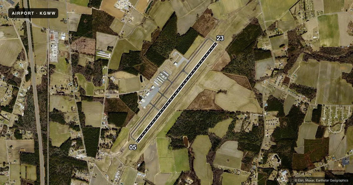
Runways & pattern
Full pagePattern entry · RWY 05
LEFT TRAFFICRunway end performance
| End | TORA | TODA | ASDA | LDA | VGSI | Approach lights | Obstruction |
|---|---|---|---|---|---|---|---|
| 05 | — | — | — | — | PAPI 4-box left(3°) | — | 68', trees, 2354' from thr, 462' R of cntrln, slope 31 |
| 23 | — | — | — | — | PAPI 4-box left(3°) | ODALS | 66', trees, 3198' from thr, 89' R of cntrln, slope 45 |
Declared distances in feet. TORA = takeoff run available, TODA = takeoff distance, ASDA = accelerate-stop, LDA = landing distance.
Airport sketch
Runways drawn to scale from FAA survey coordinates, rendered over satellite imagery. Not for navigation.
Approaches & charts
ILS · 1
Services on the field
Fuel grades, oxygen, maintenance, ramp storage and lighting — as declared to the FAA by the airport operator.
Fuel & services
- Fuel
- 100LLA1+
- Oxygen (bottled)
- Not available
- Oxygen (bulk)
- Not available
- Airframe repair
- Major
- Power plant repair
- Major
- Other services
- AGRI,INSTR,RNTL
Ramp & ground
- Transient storage
- Tie-down
- Hangar
- Landing fee
- No fee published
- Customs
- Not available
- Lighting schedule
- SEE RMK
- Beacon schedule
- SEE RMK
- Beacon
- White / Green (civil land)(WG)
- Wind indicator
- Lighted
- Segmented circle
- Yes
Fuel & FBOs
Cheapest 100LL and Jet A on the field and nearby. Always confirm with the FBO before taxi.
Airport notes
Surface conditions, obstructions, local procedures, lighting outages and other notes published with each FAA cycle.
General notes
- ULTRALIGHT; GLIDER & PARACHUTE ACTIVITY PPR CALL 919-734-7630.
- HELICOPTER OPS ON TWY LEADING TO T HANGERS. HELIPAD ON TWY WITH TRAFFIC CONES AND FLAGS.
- BIRD ACTIVITY INVOF ARPT.
- FOR EMERG SVC AFT HRS CALL 919-734-7630.
- FOR CD CTC SEYMOUR JOHNSON APCH AT 919-722-4186. WHEN APCH CLSD, FOR CD CTC WASHINGTON ARTCC AT 703-771-3587.
Lighting notes
- SS-SR
- ACTVT ODALS RWY 23; REIL RWY 05; MIRL RWY 05/23 - CTAF. PAPI RWYS 05 & 23 ON CONSLY.
Fuel notes
- 100LL24 HR SS FUEL AVAILABLE W CC.
Approach & departure obstructions
- 23RWY 23 PAPI NOT COINCIDENTAL WITH ILS RWY 23 GS.
Other notes
- 3UNATNDD FEDERAL HOL.
VFR map & nearby airports
VFR sectional. Tap any ICAO chip to open that airport.
Key facts · KGWW
Answer card- ICAO
- KGWW
- Name
- WAYNE EXEC JETPORT
- Location
- GOLDSBORO, NORTH CAROLINA
- Elevation
- 133.6 ft MSL
- Traffic pattern altitude
- 1,133.6 ft MSL (1,000 AGL)
- Control tower
- Non-towered (use CTAF)
- Total runways
- 1
- Longest runway
- 05/23 · 5,501 ft
- Published ILS approaches
- 1
- Published frequencies
- 4
- Magnetic variation
- 8°
- Current flight rules
- IFR
- Current wind
- 000° at 0 kt
- Favored runway now
- –
Wayne Executive Jetport is in Goldsboro, North Carolina. The field elevation is 133.6 ft MSL. It has one runway, 05/23, which is 5,501 ft long. There is no control tower. Clearance delivery is handled by Seymour Johnson Approach when it is open. If approach is closed, use Washington ARTCC for clearance delivery. The airport has one ILS approach to runway 23. Pattern altitude is not published. Use the standard 1,000 ft AGL for light piston traffic unless current local guidance says otherwise.
The on-field FBO is Wayne Executive Jetport. It carries 100LL and Jet A Prist. 100LL is available 24 hours after sunset with a credit card. Runway lighting is pilot-controlled on CTAF. Runway end identifier lights are active on both ends. PAPI is on both runway ends. Runway 23 also has an omni-directional approach lighting system. One thing to brief before arrival is the brush obstruction near runway 05. It is 9 ft high and sits 135 ft from the threshold, offset left of centerline. Bird activity is also reported in the area. Helicopter operations occur on the taxiway leading to the T hangars. A marked helipad is there. Ultralight, glider and parachute activity need prior permission. Check the current FAA Chart Supplement for any published noise or curfew restrictions before flying in.