METAR & TAF KJNX
Current METAR
Observed 03:35Z
KJNX 240335Z AUTO 00000KT 10SM OVC060 21/18 A3003 RMK AO2
- Wind
- 000° @ 0 kt
- Visibility
- 10 SM
- Temp / Dew
- 21°C / 18°C
- Altimeter
- 30.03 inHg
- Clouds
- OVC
- Density alt
- 787 ft
- Ceiling
- 6,000 ft AGL
- Rules
- VFR
Airport info & contacts
Manager on record, flight service, ARTCC, attendance schedule and pattern altitude — published by the FAA and refreshed every 28 days.
Location
- From city
- 3 NM NW
- VFR sectional
- CHARLOTTE
- Pattern altitude
- 1,035 ft AGL · 1,199 ft MSL
- ARTCC
- ZDC · WASHINGTON
- NOTAM facility
- JNX (NOTAM-D)
Airport manager
- Name
- DAVID HARRIS
- Phone
- 919-934-0992
- Address
- 3149 SWIFT CREEK RD, SMITHFIELD NC 27577-9803
Flight service · Hours
- FSS RDU
- RALEIGH1-800-WX-BRIEF
- Attendance
- 0800-1800
Frequencies
Tap any row to copy the frequency to your clipboard.
Runways & pattern
Full pagePattern entry · RWY 03
LEFT TRAFFICRunway end performance
| End | TORA | TODA | ASDA | LDA | VGSI | Approach lights | Obstruction |
|---|---|---|---|---|---|---|---|
| 03 | — | — | — | — | PAPI 4-box left(3°) | MALSR | 49', trees, 1167' from thr, 304' R of cntrln, slope 19 |
| 21 | — | — | — | — | PAPI 4-box left(4°) | — | 36', trees, 241' from thr, 435' R of cntrln, slope 1 |
Declared distances in feet. TORA = takeoff run available, TODA = takeoff distance, ASDA = accelerate-stop, LDA = landing distance.
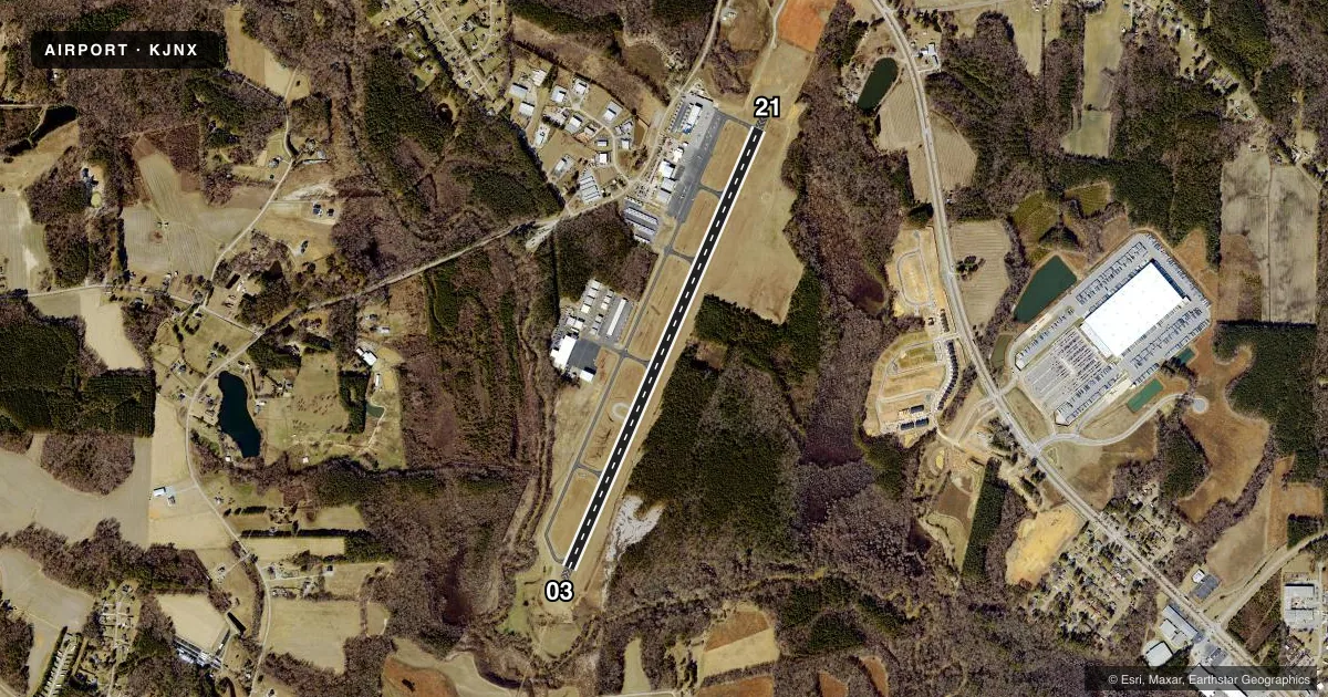
Airport sketch
Runways drawn to scale from FAA survey coordinates, rendered over satellite imagery. Not for navigation.
Approaches & charts
ILS · 1
Services on the field
Fuel grades, oxygen, maintenance, ramp storage and lighting — as declared to the FAA by the airport operator.
Fuel & services
- Fuel
- 100LLA1+
- Oxygen (bottled)
- Not available
- Oxygen (bulk)
- Not available
- Airframe repair
- Major
- Power plant repair
- Major
- Other services
- AMB,AVNCS,INSTR,RNTL
Ramp & ground
- Transient storage
- Tie-down
- Landing fee
- No fee published
- Lighting schedule
- SEE RMK
- Beacon schedule
- SS-SR
- Beacon
- White / Green (civil land)(WG)
- Wind indicator
- Lighted
- Segmented circle
- Yes
Fuel & FBOs
Cheapest 100LL and Jet A on the field and nearby. Always confirm with the FBO before taxi.
Airport notes
Surface conditions, obstructions, local procedures, lighting outages and other notes published with each FAA cycle.
General notes
- AVOID OVERFLIGHTS OF HOUSING AREA IN TFC PAT FOR NOISE ABATEMENT. FLY WIDER DNWNDS & LONGER DEP LEGS.
- DEER AND COYOTE ON & INVOF ARPT.
- RWY 21 HAS +65 FT UNMKD PLINE 2000 FT FM THR LEFT AND RIGHT OF CNTRLN.
- 50 FT AGL TWR 200 FT SW OF RWY 03 CNTRLN.
- GCO AVBL ON FREQ 135.075 THRU RDU CD & FLT SVCS.
- BE ALERT WHEN TAXING NEAR SOUTH RAMP/CORPORATE HNGR.
- KEY CODE ACES TO PILOT LOUNGE AT PILOT/CREW RAMP.
- HEL FLT T OPS INVOF ARPT.
- GPU AVBL.
- FOR CD IF RALEIGH APCH UNA VIA GCO CTC RALEIGH APCH AT 919-380-3144.
Lighting notes
- ACTVT MALSR RWY 03; REIL RWY 21; MIRL 03/21; TWY LGTS - CTAF. PAPI RWY 03 & 21 OPER CONSLY.
Runway surface & condition
- 03/21HAS A 150 FT SWY ON BOTH ENDS.
Approach & departure obstructions
- 0329 FT TREES 0-200 FT FROM THLD OFFSET 425 FT LEFT OF CNTRLN.
- 216 FT GROUND 0-200 FT FR THR OFFSET 301 FT LEFT OF CNTRLN, AND 54 FT TRESS 122 FT FR THR OFFSET 442 FT LEFT OF CNTRLN.
Other notes
- 1UNATNDD THANKSGIVING AND CHRISTMAS DAY.
VFR map & nearby airports
VFR sectional. Tap any ICAO chip to open that airport.
Key facts · KJNX
Answer card- ICAO
- KJNX
- Name
- JOHNSTON RGNL
- Location
- SMITHFIELD, NORTH CAROLINA
- Elevation
- 164 ft MSL
- Traffic pattern altitude
- 1,199 ft MSL (1,035 AGL)
- Control tower
- Non-towered (use CTAF)
- Total runways
- 1
- Longest runway
- 03/21 · 5,500 ft
- Published ILS approaches
- 1
- Published frequencies
- 4
- Magnetic variation
- 9°
- Current flight rules
- VFR
- Current wind
- 000° at 0 kt
- Favored runway now
- –
Johnston Regional Airport sits in Smithfield, North Carolina. Field elevation is 164 ft MSL. The airport has one runway, 03/21, which is 5,500 ft long with an asphalt surface. There is no control tower. Pattern altitude is 1,035 ft AGL, which is 1,199 ft MSL.
Runway 03 has an ILS approach. The field uses CTAF 122.725. Raleigh Approach handles approach and departure on 125.3 and 353.675. Johnston Regional Airport is on the field. It carries 100LL and Jet A. Call the FBO at (919) 934-0992 for current service details.
A few published remarks matter here. Runway 03 has MALSR lighting. Runway 21 has runway end identifier lights. PAPI runs continuously on both ends. Taxiway lights are controlled by CTAF. The airport also has a 150 ft stopway on both ends of runway 03/21. Noise abatement is a real factor here. Avoid overflights of the housing area in the pattern. Fly a wider downwind and longer departure legs. Helicopter training also happens in the area. Watch the south ramp and corporate hangar when taxiing.