METAR & TAF W03
W03 does not publish a METAR.
Showing the nearest reporting station: KRWI (ROCKY MOUNT/WILSON RGNL) · 6.4 NM away. Conditions at W03 may differ.
METAR · KRWI
Observed 13:15Z
KRWI 271315Z AUTO 20003KT 10SM BKN019 25/22 A2986 RMK AO2 T02500217
- Wind
- 200° @ 3 kt
- Visibility
- 10 SM
- Temp / Dew
- 25°C / 22°C
- Altimeter
- 29.86 inHg
- Clouds
- BKN
- Density alt
- 1,472 ft
- Ceiling
- 1,900 ft AGL
- Rules
- MVFR
Airport info & contacts
Manager on record, flight service, ARTCC, attendance schedule and pattern altitude — published by the FAA and refreshed every 28 days.
Location
- From city
- 3 NM N
- VFR sectional
- CHARLOTTE
- ARTCC
- ZDC · WASHINGTON
- NOTAM facility
- RDU (NOTAM-D)
Airport manager
- Name
- GRONNA JONES
- Phone
- 252-399-2489
- Address
- PO BOX 10, WILSON NC 27894
Flight service · Hours
- FSS RDU
- RALEIGH1-800-WX-BRIEF
- Attendance
- 0800-1800
Frequencies
Tap any row to copy the frequency to your clipboard.
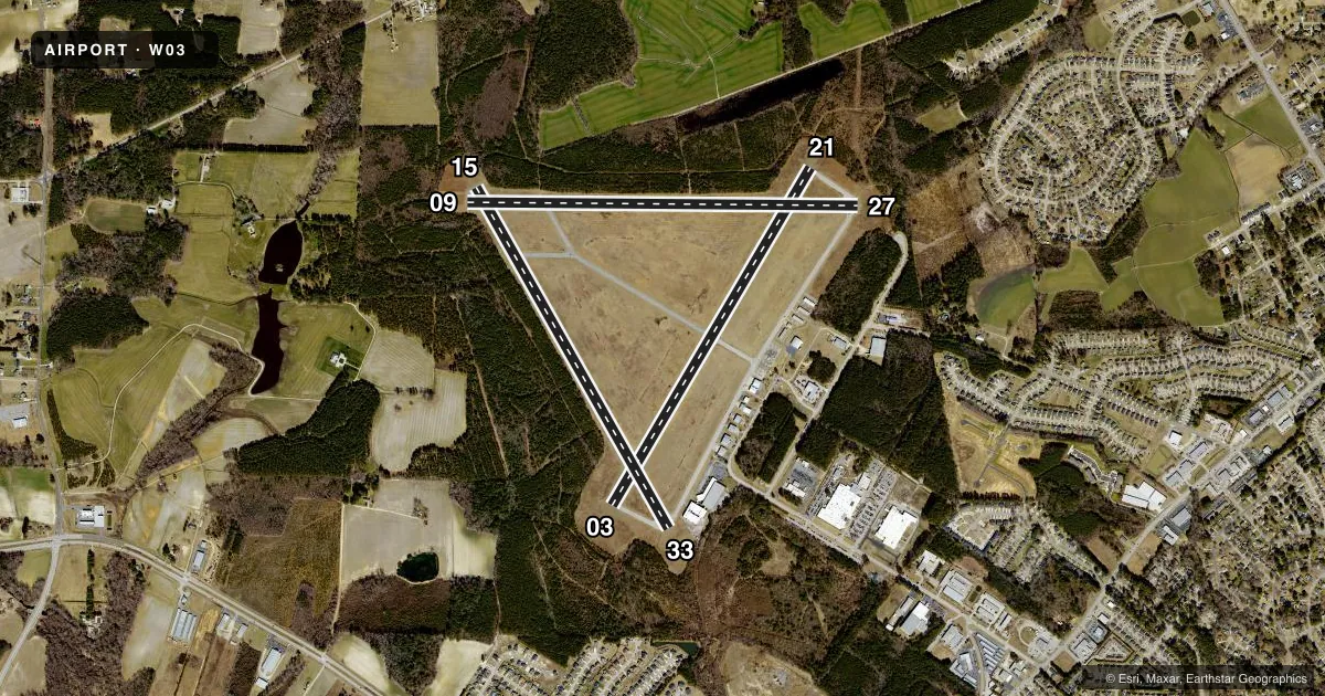
Runways & pattern
Full pagePattern entry · RWY 21
LEFT TRAFFIC| Runway | Heading (°M) | Length | Surface | Traffic |
|---|---|---|---|---|
| 03/21Favored | 23° / 203° | 4,500 ft | ASPH | Standard L |
| 15/33 | 142° / 322° | 4,499 ft | ASPH | Standard L |
| 09/27 | 82° / 262° | 4,498 ft | ASPH | Standard L |
Runway end performance
| End | TORA | TODA | ASDA | LDA | VGSI | Approach lights | Obstruction |
|---|---|---|---|---|---|---|---|
| 03 | — | — | — | — | — | — | 15', trees, 522' from thr, 212' R of cntrln, slope 21 |
| 21 | — | — | — | — | — | — | 13', trees, 271' from thr, 117' R of cntrln, slope 5 |
| 15 | — | — | — | — | — | — | 34', trees, 362' from thr, 201' R of cntrln, slope 4 |
| 33 | — | — | — | — | — | — | 44', trees, 328' from thr, 209' R of cntrln, slope 2 |
| 09 | — | — | — | — | — | — | 38', trees, 530' from thr, 57' R of cntrln, slope 8 |
| 27 | — | — | — | — | — | — | 43', trees, 464' from thr, 130' R of cntrln, slope 6 |
Declared distances in feet. TORA = takeoff run available, TODA = takeoff distance, ASDA = accelerate-stop, LDA = landing distance.
Airport sketch
Runways drawn to scale from FAA survey coordinates, rendered over satellite imagery. Not for navigation.
Approaches & charts
Services on the field
Fuel grades, oxygen, maintenance, ramp storage and lighting — as declared to the FAA by the airport operator.
Fuel & services
- Fuel
- 100LLA1+
- Oxygen (bottled)
- Not available
- Oxygen (bulk)
- Not available
- Airframe repair
- Not available
- Power plant repair
- Not available
Ramp & ground
- Transient storage
- Tie-down
- Hangar
- Landing fee
- No fee published
- Customs
- Not available
- Lighting schedule
- SEE RMK
- Beacon schedule
- SS-SR
- Beacon
- White / Green (civil land)(WG)
- Wind indicator
- Lighted
- Segmented circle
- No
Fuel & FBOs
Cheapest 100LL and Jet A on the field and nearby. Always confirm with the FBO before taxi.
Airport notes
Surface conditions, obstructions, local procedures, lighting outages and other notes published with each FAA cycle.
General notes
- NO LINE-OF-SIGHT BTN RWY ENDS.
- DEER ON & INVOF ARPT.
- FOR CD CTC WASHINGTON ARTCC AT 703-771-3587.
Lighting notes
- ACTVT REIL RWY 03/21; MIRL RWY 03/21 - CTAF.
Approach & departure obstructions
- 09DUE TO 28 FT TREES 0-200 FT FM END AND OFFSET 136 FT RIGHT OF CNTRLN.
- 15DUE TO 32 FT TREES 0-200 FT FM END AND OFFSET 169 FT LEFT OF CNTRLN.
- 33DUE TO 20 FT BLDG 5 FT FM END AND OFFSET 243 FT RIGHT OF CNTRLN.
- 03RWY 03/21 OTS INDEF.
- 09DUE TO LINE UNDER RWY NR AND LCTN FM END.
- 15DUE TO LINE UNDER RWY NR AND LCTN FM END.
Other notes
- CALL FOR AVBL.
- 1UNATNDD THANKSGIVING AND CHRISTMAS DAY. FOR SVC AFT HRS CALL 252-361-0663.
- 1FOR SVC AFT HRS CALL 252-292-8443.
- MANAGERARPT PHONE NR 252-991-6336.
- 09/27ROUGH SFC DUE TO EXCESSIVE CRACK SEALANT.
- 15/33L & T AND BLOCK CRACKING, FOD, FAILED SEALANT.
VFR map & nearby airports
VFR sectional. Tap any ICAO chip to open that airport.
Key facts · W03
Answer card- ICAO
- W03
- Name
- WILSON INDUSTRIAL AIR CENTER
- Location
- WILSON, NORTH CAROLINA
- Elevation
- 159.6 ft MSL
- Traffic pattern altitude
- 1,159.6 ft MSL (1,000 AGL)
- Control tower
- Non-towered (use CTAF)
- Total runways
- 3
- Longest runway
- 03/21 · 4,500 ft
- Published ILS approaches
- 0
- Published frequencies
- 2
- Magnetic variation
- 8°
- Current flight rules
- MVFR
- Current wind
- 200° at 3 kt
- Favored runway now
- RWY 21
Wilson Industrial Air Center sits in Wilson, North Carolina. Field elevation is 159.6 ft MSL. The airport has three asphalt runways. The longest is 4,500 ft on 03/21. There is no control tower. CTAF and UNICOM are both 123.0. No ILS approaches are published.
Pattern altitude is not published. Use the standard 1,000 ft AGL pattern for light piston traffic unless the current Chart Supplement says otherwise. Runway 03/21 has activated runway end identifier lights and medium intensity runway lights on CTAF. The runway end lights on 03/21 are out of service indefinitely. That matters at night or in reduced visibility.
The published remarks also show close-in obstructions on several ends. Runway 09 has trees near the departure end. Runway 15 has trees near the departure end. Runway 33 has a building close to the end. Runway 15/33 also has cracking. Foreign object debris and failed sealant are reported. There is no line of sight between runway ends, so do not assume you can visually confirm traffic from one end to the other. For clearance delivery, contact Washington ARTCC. If you need transient storage hangar space, call ahead. No on-field FBOs are listed, so verify services with the airport operator or call the field before arrival.