METAR & TAF KETC
Current METAR
Observed 16:35Z
KETC 271635Z AUTO 00000KT 7SM BKN024 OVC036 27/23 A2986 RMK AO2 T02750230
- Wind
- 000° @ 0 kt
- Visibility
- 7 SM
- Temp / Dew
- 27°C / 23°C
- Altimeter
- 29.86 inHg
- Clouds
- OVC
- Density alt
- 1,580 ft
- Ceiling
- 2,400 ft AGL
- Rules
- MVFR
Airport info & contacts
Manager on record, flight service, ARTCC, attendance schedule and pattern altitude — published by the FAA and refreshed every 28 days.
Location
- From city
- 2 NM N
- VFR sectional
- CHARLOTTE
- ARTCC
- ZDC · WASHINGTON
- NOTAM facility
- RDU (NOTAM-D)
Airport manager
- Name
- JASON NICHOLS
- Phone
- (252) 641-4229
- Address
- PO BOX 220, TARBORO NC 27886
Flight service · Hours
- FSS RDU
- RALEIGH1-800-WX-BRIEF
- Attendance
- Unattended
Frequencies
Tap any row to copy the frequency to your clipboard.
Runways & pattern
Full pagePattern entry · RWY 09
LEFT TRAFFICRunway end performance
| End | TORA | TODA | ASDA | LDA | VGSI | Approach lights | Obstruction |
|---|---|---|---|---|---|---|---|
| 09 | — | — | — | — | PAPI 2-box left(4°) | — | 9', trees, 212' from thr, 0' R of cntrln, slope 1 |
| 27 | — | — | — | — | PAPI 2-box left(3°) | — | 24', trees, 542' from thr, 272' R of cntrln, slope 14 |
Declared distances in feet. TORA = takeoff run available, TODA = takeoff distance, ASDA = accelerate-stop, LDA = landing distance.
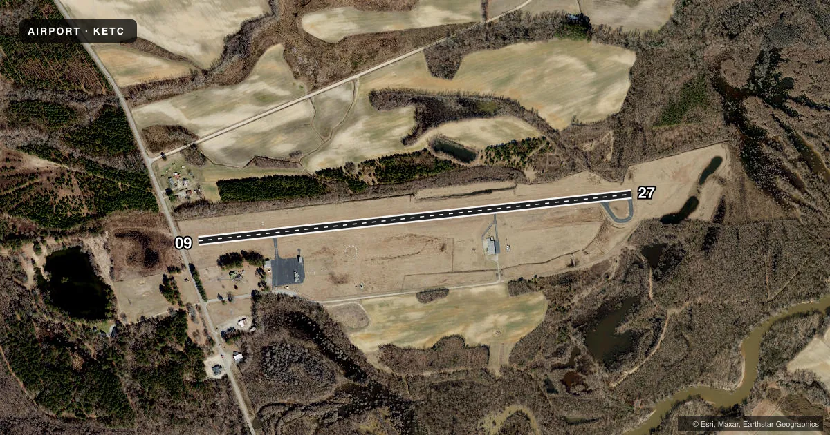
Airport sketch
Runways drawn to scale from FAA survey coordinates, rendered over satellite imagery. Not for navigation.
Approaches & charts
Services on the field
Fuel grades, oxygen, maintenance, ramp storage and lighting — as declared to the FAA by the airport operator.
Fuel & services
- Fuel
- 100LL
- Oxygen (bottled)
- Not available
- Oxygen (bulk)
- Not available
- Airframe repair
- Not available
- Power plant repair
- Not available
- Other services
- AGRI
Ramp & ground
- Transient storage
- Tie-down
- Landing fee
- No fee published
- Lighting schedule
- SEE RMK
- Beacon schedule
- SS-SR
- Beacon
- White / Green (civil land)(WG)
- Wind indicator
- Lighted
- Segmented circle
- Yes
Fuel & FBOs
Cheapest 100LL and Jet A on the field and nearby. Always confirm with the FBO before taxi.
Airport notes
Surface conditions, obstructions, local procedures, lighting outages and other notes published with each FAA cycle.
General notes
- DEER ON AND INVOF ARPT.
- 500 FT LOW LEVEL RTE 3 MI NE OF ARPT - BE ALERT FOR MIL ACFT INVOF ARPT.
- RWY 27 SAFETY AREA HAS SFC VARIATIONS & DEPRESSIONS AND A 20 FT DROP-OFF 100 FT FM BOTH SIDES.
- FOR CD CTC WASHINGTON ARTCC AT 703-771-3587.
Lighting notes
- ACTVT REIL RWY 27; PAPI RWY 09 & 27; MIRLS RWY 09/27 - CTAF.
Fuel notes
- 100LLSELF SVC 100LL AVBL 24 HRS WITH CREDIT CARD.
Approach & departure obstructions
- 0915 FT ROAD 162 FT FM END BOTH SIDES CNTRLN; 3 FT FENCE 126 FT FM END BOTH SIDES CNTRLN.
- 09RWY 09 APCH SLP 14:1 DUE TO 15 FT ROAD 385 FT FM THE DSPLCD THLD BOTH SIDES OF CNTRLN.
Other notes
- MANAGEREMERG PHONE DURG BUS HRS 252-641-4229 TOWN HALL; 252-641-4247 POLICE DISPATCH.
VFR map & nearby airports
VFR sectional. Tap any ICAO chip to open that airport.
Key facts · KETC
Answer card- ICAO
- KETC
- Name
- TARBORO-EDGECOMBE
- Location
- TARBORO, NORTH CAROLINA
- Elevation
- 52.6 ft MSL
- Traffic pattern altitude
- 1,052.6 ft MSL (1,000 AGL)
- Control tower
- Non-towered (use CTAF)
- Total runways
- 1
- Longest runway
- 09/27 · 3,999 ft
- Published ILS approaches
- 0
- Published frequencies
- 1
- Magnetic variation
- 8°
- Current flight rules
- MVFR
- Current wind
- 000° at 0 kt
- Favored runway now
- –
Tarboro-Edgecombe Airport sits in Tarboro, North Carolina. Field elevation is 52.6 ft MSL. The airport has one runway, 09/27, which is 3,999 ft long. There is no control tower. CTAF is 122.9.
No ILS approaches are published here. Pattern altitude is not published, so use the standard 1,000 ft AGL for light piston traffic unless the current FAA Chart Supplement says otherwise. Runway lighting is useful for night work. Runway 27 has REIL. PAPI is available on both runways. MIRLs are on 09 and 27 and are controlled by CTAF.
For fuel, self-service 100LL is available 24 hours with a credit card. No on-field FBOs are listed. First-time pilots should pay attention to the published runway 09 obstruction notes. The approach slope is affected by a road near the threshold. Runway 27 also has a reported safety area with surface variations and a drop-off beyond the edge. Deer are reported on and near the airport. There is also a low-level military route 3 miles northeast of the field, so keep a sharp scan in the area. For clearance delivery, contact Washington ARTCC at 703-771-3587.