METAR & TAF 05N
05N does not publish a METAR.
Showing the nearest reporting station: KPGV (PITT-GREENVILLE) · 9.3 NM away. Conditions at 05N may differ.
METAR · KPGV
Observed 16:15Z
KPGV 271615Z AUTO 20005KT 10SM SCT050 SCT060 BKN085 29/23 A2985 RMK AO2
- Wind
- 200° @ 5 kt
- Visibility
- 10 SM
- Temp / Dew
- 29°C / 23°C
- Altimeter
- 29.85 inHg
- Clouds
- BKN
- Density alt
- 1,829 ft
- Ceiling
- 8,500 ft AGL
- Rules
- VFR
Airport info & contacts
Manager on record, flight service, ARTCC, attendance schedule and pattern altitude — published by the FAA and refreshed every 28 days.
Location
- From city
- 5 NM SE
- VFR sectional
- CHARLOTTE
- ARTCC
- ZDC · WASHINGTON
- NOTAM facility
- RDU (NOTAM-D)
Airport manager
- Name
- CHARLES A. LEWIS JR
- Phone
- 252-714-0514
- Address
- 5245 COUNTY HOME ROAD, WINTERVILLE NC 28590
Flight service · Hours
- FSS RDU
- RALEIGH1-800-WX-BRIEF
- Attendance
- Unattended
Frequencies
Tap any row to copy the frequency to your clipboard.
Runways & pattern
Full pagePattern entry · RWY 25
LEFT TRAFFICRunway end performance
| End | TORA | TODA | ASDA | LDA | VGSI | Approach lights | Obstruction |
|---|---|---|---|---|---|---|---|
| 07 | — | — | — | — | — | — | 69', trees, 367' from thr, 100' R of cntrln, slope 5 |
| 25 | — | — | — | — | — | — | 66', trees, 279' from thr, 122' R of cntrln, slope 4 |
Declared distances in feet. TORA = takeoff run available, TODA = takeoff distance, ASDA = accelerate-stop, LDA = landing distance.
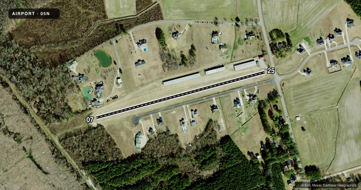
Airport sketch
Runways drawn to scale from FAA survey coordinates, rendered over satellite imagery. Not for navigation.
Approaches & charts
Services on the field
Fuel grades, oxygen, maintenance, ramp storage and lighting — as declared to the FAA by the airport operator.
Fuel & services
- Fuel
- Not available
- Other services
- INSTR
Ramp & ground
- Transient storage
- Tie-down
- Wind indicator
- Yes
- Segmented circle
- No
Fuel & FBOs
Cheapest 100LL and Jet A on the field and nearby. Always confirm with the FBO before taxi.
Airport notes
Surface conditions, obstructions, local procedures, lighting outages and other notes published with each FAA cycle.
General notes
- RWY 07/25 MKD WITH YELLOW CONES.
- DALGT USE ONLY.
- FOR CD CTC WASHINGTON ARTCC AT 703-771-3587.
- RWY 25 HAS 15 FT+/- ROAD 150 FT +/- FM THR BOTH SIDE OF CNTRLN AND 10 FT+/- DRIVEWAY 25 FT +/- FM THR OFFSET 5 FT +/- RIGHT OF CNTRLN.
- RWY 07 HAS 20 FT DROP-OFF 80 FT FR THR BOTH SIDES CNTRLN.
Other notes
- PRVDD VFR OPNS AND PRVT USE.
- OPEN SHELTERS AVBL.
- OWNERARPT PHYS ADS: 6440 COUNTY HOME ROAD
VFR map & nearby airports
VFR sectional. Tap any ICAO chip to open that airport.
Key facts · 05N
Answer card- ICAO
- 05N
- Name
- SOUTH OAKS AERODROME
- Location
- WINTERVILLE, NORTH CAROLINA
- Elevation
- 50 ft MSL
- Traffic pattern altitude
- 1,050 ft MSL (1,000 AGL)
- Control tower
- Non-towered (use CTAF)
- Total runways
- 1
- Longest runway
- 07/25 · 1,850 ft
- Published ILS approaches
- 0
- Published frequencies
- 2
- Magnetic variation
- –
- Current flight rules
- VFR
- Current wind
- 200° at 5 kt
- Favored runway now
- RWY 25
South Oaks Aerodrome sits in Winterville, North Carolina. The field elevation is 50 ft MSL. It has one runway. Runway 07/25 is 1,850 ft of turf, so this is a short-field stop for light aircraft only. There is no control tower. CTAF and UNICOM are both 122.8. No ILS approaches are published.
Pattern altitude is not published. Use the standard 1,000 ft AGL pattern for light piston operations unless the current Chart Supplement says otherwise. This is a daylight-use-only field. That matters here. Plan your arrival and departure with enough light to handle the turf surface and the nearby obstacles.
Published remarks call out a road near the Runway 25 threshold. They also note a driveway close to that end. Runway 07 has a drop-off near the threshold area. The runway is marked with yellow cones. Expect a private-use, VFR-only environment. Open shelters are available on the field. For clearance delivery, contact Washington ARTCC at 703-771-3587. There are no on-field FBOs listed, so verify fuel and services with the airport operator or the field directly before you go.