METAR & TAF KMCZ
Current METAR
Observed 16:35Z
KMCZ 261635Z AUTO 23003KT 10SM OVC031 26/20 A2996 RMK AO2 T02580205
- Wind
- 230° @ 3 kt
- Visibility
- 10 SM
- Temp / Dew
- 26°C / 20°C
- Altimeter
- 29.96 inHg
- Clouds
- OVC
- Density alt
- 1,363 ft
- Ceiling
- 3,100 ft AGL
- Rules
- VFR
Airport info & contacts
Manager on record, flight service, ARTCC, attendance schedule and pattern altitude — published by the FAA and refreshed every 28 days.
Location
- From city
- 6 NM W
- VFR sectional
- CHARLOTTE
- ARTCC
- ZDC · WASHINGTON
- NOTAM facility
- RDU (NOTAM-D)
Airport manager
- Name
- JESSE COUNCIL, JULIET CHARLIE AVIAT
- Phone
- 252-792-1971
- Address
- 2135 AIRPORT RD, WILLIAMSTON NC 27892
Flight service · Hours
- FSS RDU
- RALEIGH1-800-WX-BRIEF
- Attendance
- 0800-1700
Frequencies
Tap any row to copy the frequency to your clipboard.
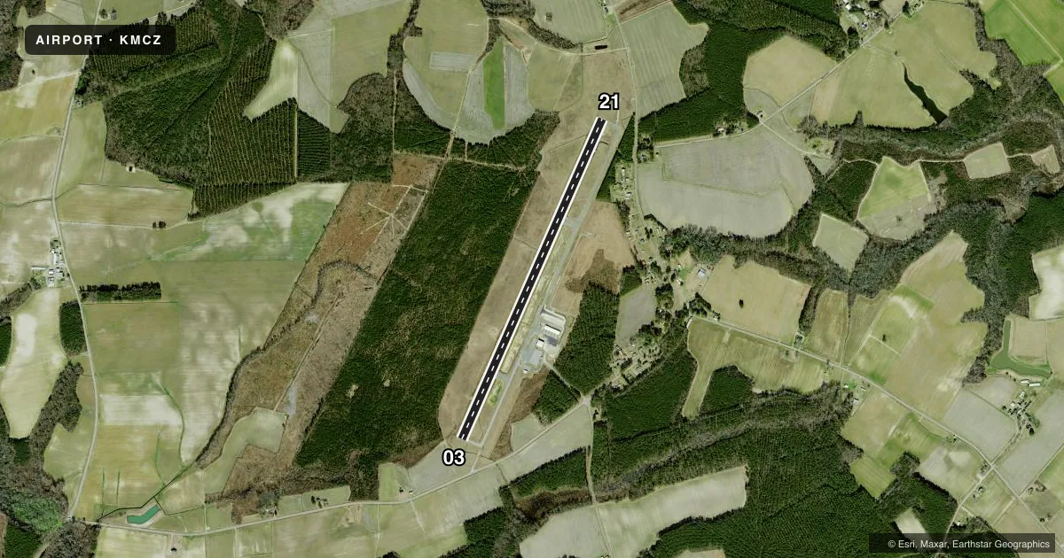
Runways & pattern
Full pagePattern entry · RWY 21
LEFT TRAFFICRunway end performance
| End | TORA | TODA | ASDA | LDA | VGSI | Approach lights | Obstruction |
|---|---|---|---|---|---|---|---|
| 03 | — | — | — | — | PAPI 2-box left(3°) | — | 16', road, 416' from thr, 259' R of cntrln, slope 13 |
| 21 | — | — | — | — | PAPI 2-box left(3°) | — | 15', road, 587' from thr, 242' R of cntrln, slope 25 |
Declared distances in feet. TORA = takeoff run available, TODA = takeoff distance, ASDA = accelerate-stop, LDA = landing distance.
Airport sketch
Runways drawn to scale from FAA survey coordinates, rendered over satellite imagery. Not for navigation.
Approaches & charts
Services on the field
Fuel grades, oxygen, maintenance, ramp storage and lighting — as declared to the FAA by the airport operator.
Fuel & services
- Fuel
- 100LLA1
- Oxygen (bottled)
- Not available
- Oxygen (bulk)
- Not available
- Airframe repair
- Not available
- Power plant repair
- Not available
- Other services
- INSTR
Ramp & ground
- Transient storage
- Tie-down
- Hangar
- Landing fee
- No fee published
- Lighting schedule
- SEE RMK
- Beacon schedule
- SS-SR
- Beacon
- White / Green (civil land)(WG)
- Wind indicator
- Lighted
- Segmented circle
- Yes
Fuel & FBOs
Cheapest 100LL and Jet A on the field and nearby. Always confirm with the FBO before taxi.
Airport notes
Surface conditions, obstructions, local procedures, lighting outages and other notes published with each FAA cycle.
General notes
- DEER ON AND INVOF ARPT.
- FOR CD CTC WASHINGTON ARTCC AT 703-771-3587.
- RWY 03 HAS 10-15 FT DROP-OFF 70 FT FM CNTRLN BOTH SIDES.
- RWY 03 HAS A MKD DSPLCD THR OF 45 FT (UNPUBLD).
Lighting notes
- PAPI RWY 03 & 21 OPR CONSLY. MIRL RWY 03/21 DUSK TO DAWN; TO CHG INTST - CTAF.
Fuel notes
- 100LL100LL AND JET-A HAS 24 HR SELF-SVC WITH CREDIT CARD.
Approach & departure obstructions
- 03OTS INDEF.
- 03APCH SLOPE 23:1 AT DSPLCD.
Other notes
- 1FOR SVC AFT HRS CALL 252-799-8718 OR 252-217-4023.
VFR map & nearby airports
VFR sectional. Tap any ICAO chip to open that airport.
Key facts · KMCZ
Answer card- ICAO
- KMCZ
- Name
- MARTIN COUNTY
- Location
- WILLIAMSTON, NORTH CAROLINA
- Elevation
- 74.9 ft MSL
- Traffic pattern altitude
- 1,074.9 ft MSL (1,000 AGL)
- Control tower
- Non-towered (use CTAF)
- Total runways
- 1
- Longest runway
- 03/21 · 5,000 ft
- Published ILS approaches
- 0
- Published frequencies
- 2
- Magnetic variation
- 9°
- Current flight rules
- VFR
- Current wind
- 230° at 3 kt
- Favored runway now
- RWY 21
Martin County Airport (KMCZ) sits in Williamston, North Carolina. Field elevation is 74.9 ft MSL. The airport has one runway. Runway 03/21 is 5,000 ft asphalt. There is no control tower. CTAF and UNICOM are both 122.8. No ILS approaches are published here.
Pattern altitude is not published. Use the standard 1,000 ft AGL for light piston operations unless the current Chart Supplement says otherwise. Deer are reported on and near the airport. Runway 03 has a marked displaced threshold of 45 ft. The approach slope at that displaced threshold is steep. Runway 03 also has a 10 to 15 ft drop-off about 70 ft from centerline on both sides. That makes the departure and landing environment worth a close look, especially on 03.
Juliet Charlie Aviation is on the field. It carries 100LL and Jet-A. Fuel is available 24 hours self-service with credit card. For after-hours service, call the numbers in the Chart Supplement or the FBO directly. The PAPI on 03 and 21 runs continuously. Medium intensity runway lights on 03 and 21 run from dusk to dawn. Use CTAF to change intensity. For clearance delivery, contact Washington ARTCC. This is a non-towered field. Plan your self-announce work and watch for local traffic.