METAR & TAF KPMZ
KPMZ does not publish a METAR.
Showing the nearest reporting station: KEDE (NORTHEASTERN RGNL) · 16.0 NM away. Conditions at KPMZ may differ.
METAR · KEDE
Observed 05:15Z
KEDE 270515Z AUTO 16005KT 10SM CLR 23/18 A2992 RMK AO2 T02340178
- Wind
- 160° @ 5 kt
- Visibility
- 10 SM
- Temp / Dew
- 23°C / 18°C
- Altimeter
- 29.92 inHg
- Clouds
- CLR
- Density alt
- 1,005 ft
- Ceiling
- Unlimited
- Rules
- VFR
Airport info & contacts
Manager on record, flight service, ARTCC, attendance schedule and pattern altitude — published by the FAA and refreshed every 28 days.
Location
- From city
- 2 NM S
- VFR sectional
- CHARLOTTE
- ARTCC
- ZDC · WASHINGTON
- NOTAM facility
- RDU (NOTAM-D)
Airport manager
- Name
- MARY MQSCATO
- Phone
- 252-793-9801
- Address
- 1069 AIRPORT RD., PLYMOUTH NC 27962
Flight service · Hours
- FSS RDU
- RALEIGH1-800-WX-BRIEF
- Attendance
- 0800-1700
Frequencies
Tap any row to copy the frequency to your clipboard.
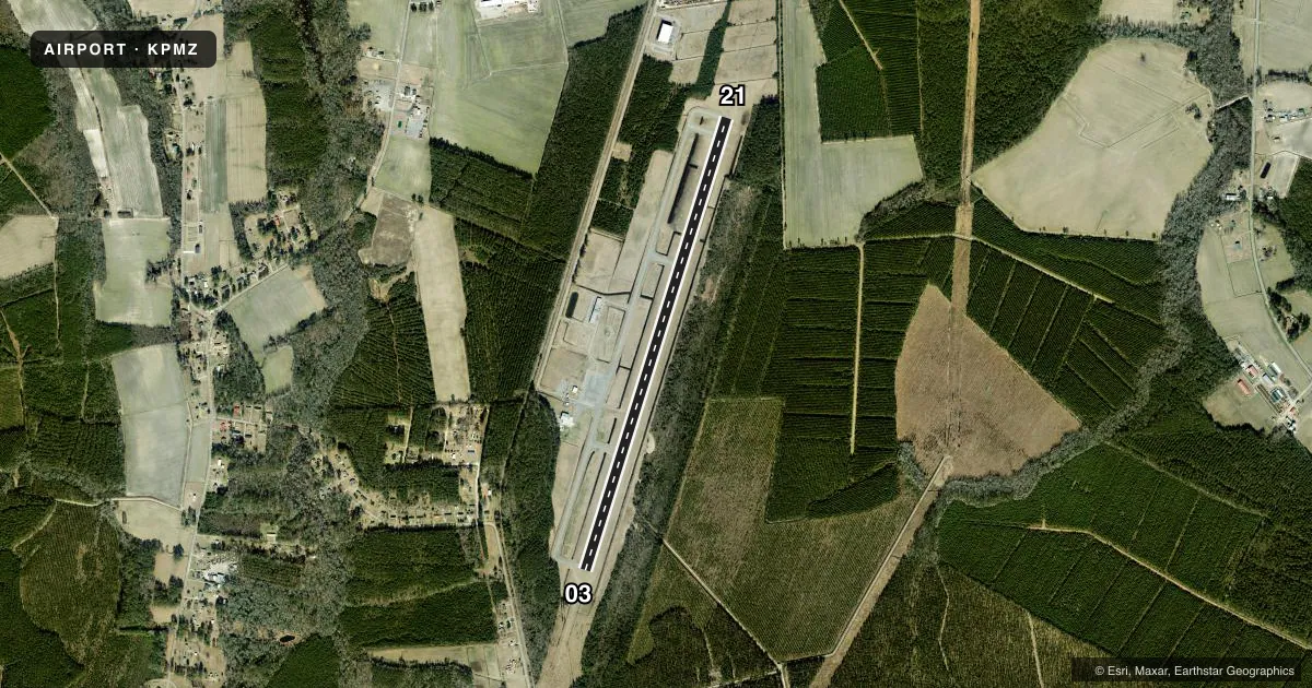
Runways & pattern
Full pagePattern entry · RWY 21
LEFT TRAFFICRunway end performance
| End | TORA | TODA | ASDA | LDA | VGSI | Approach lights | Obstruction |
|---|---|---|---|---|---|---|---|
| 03 | — | — | — | — | PAPI 2-box left(4°) | — | 43', trees, 514' from thr, 256' R of cntrln, slope 1 |
| 21 | — | — | — | — | PAPI 2-box left(4°) | — | 32', trees, 1257' from thr, 26' R of cntrln, slope 33 |
Declared distances in feet. TORA = takeoff run available, TODA = takeoff distance, ASDA = accelerate-stop, LDA = landing distance.
Airport sketch
Runways drawn to scale from FAA survey coordinates, rendered over satellite imagery. Not for navigation.
Approaches & charts
Services on the field
Fuel grades, oxygen, maintenance, ramp storage and lighting — as declared to the FAA by the airport operator.
Fuel & services
- Fuel
- 100LLA1+
- Oxygen (bottled)
- Not available
- Oxygen (bulk)
- Not available
- Airframe repair
- Not available
- Power plant repair
- Not available
- Other services
- AGRI,INSTR,RNTL
Ramp & ground
- Transient storage
- Tie-down
- Landing fee
- No fee published
- Lighting schedule
- SEE RMK
- Beacon schedule
- SS-SR
- Beacon
- White / Green (civil land)(WG)
- Wind indicator
- Lighted
- Segmented circle
- Yes
Fuel & FBOs
Cheapest 100LL and Jet A on the field and nearby. Always confirm with the FBO before taxi.
Airport notes
Surface conditions, obstructions, local procedures, lighting outages and other notes published with each FAA cycle.
General notes
- CTN: ARPT LCTD 5 MI WEST OF MIL RSTRD AREA; HI PER MIL ACFT XNG ARPT BLW 3000 FT MSL ENRT TO RSTRD AREA - XNGS ARE UNANNCD.
- DEER ACT ON & INVOF ARPT.
- FOR CD CTC WASHINGTON ARTCC AT 703-771-3587.
Lighting notes
- ACTVT REIL RWY 03 & 21; PAPI RWY 03 & 21; MIRL RWY 03/21 - CTAF.
Fuel notes
- 100LL24 HR SS FUELING WITH CC.
Other notes
- 1FOR SVC AFTER HRS CALL 252-793-9801.
VFR map & nearby airports
VFR sectional. Tap any ICAO chip to open that airport.
Key facts · KPMZ
Answer card- ICAO
- KPMZ
- Name
- PLYMOUTH MUNI
- Location
- PLYMOUTH, NORTH CAROLINA
- Elevation
- 36.3 ft MSL
- Traffic pattern altitude
- 1,036.3 ft MSL (1,000 AGL)
- Control tower
- Non-towered (use CTAF)
- Total runways
- 1
- Longest runway
- 03/21 · 5,500 ft
- Published ILS approaches
- 0
- Published frequencies
- 4
- Magnetic variation
- 10°
- Current flight rules
- VFR
- Current wind
- 160° at 5 kt
- Favored runway now
- RWY 21
Plymouth Muni sits in Plymouth, North Carolina. Field elevation is 36.3 ft MSL. The airport has one runway. Runway 03/21 is 5,500 ft of asphalt, so it gives light aircraft and many twins enough room for normal operations. There is no control tower. Pattern altitude is not published, so use the standard 1,000 ft AGL for light piston traffic unless current local guidance says otherwise. No ILS approaches are published here.
The on-field FBO is Plymouth Municipal Airport. It carries 100LL and Jet A Prist. The field also has 24-hour sunset fueling with credit card access. For after-hours service, call the airport at (252) 793-9801. Runway end identifier lights are installed on 03 and 21. PAPI is installed on both ends. Medium intensity runway lights are controlled on CTAF. That makes night ops straightforward if you brief the lighting before arrival.
There are a few local items to respect. The airport is 5 miles west of a military restricted area. High performance military aircraft cross below 3,000 ft MSL without notice. Deer are active on and near the airport. If you need clearance delivery, contact Washington ARTCC at 703-771-3587. Check the current Chart Supplement and plan your arrival with the local traffic picture in mind.