METAR & TAF KEDE
Current METAR
Observed 16:35Z
KEDE 271635Z AUTO 15006KT 10SM SCT034 BKN047 OVC110 28/24 A2985 RMK AO2 T02750243
- Wind
- 150° @ 6 kt
- Visibility
- 10 SM
- Temp / Dew
- 28°C / 24°C
- Altimeter
- 29.85 inHg
- Clouds
- OVC
- Density alt
- 1,670 ft
- Ceiling
- 4,700 ft AGL
- Rules
- VFR
Airport info & contacts
Manager on record, flight service, ARTCC, attendance schedule and pattern altitude — published by the FAA and refreshed every 28 days.
Location
- From city
- 3 NM SE
- VFR sectional
- WASHINGTON
- ARTCC
- ZDC · WASHINGTON
- NOTAM facility
- EDE (NOTAM-D)
Airport manager
- Name
- DURWOOD COPELAND
- Phone
- 252-333-6665
- Address
- 113 AIRPORT ROAD, EDENTON NC 27932
Flight service · Hours
- FSS RDU
- RALEIGH1-800-WX-BRIEF
- Attendance
- 0800-1700
Frequencies
Tap any row to copy the frequency to your clipboard.
Runways & pattern
Full pagePattern entry · RWY 19
LEFT TRAFFICRunway end performance
| End | TORA | TODA | ASDA | LDA | VGSI | Approach lights | Obstruction |
|---|---|---|---|---|---|---|---|
| 01 | — | — | — | — | PAPI 2-box left(3°) | — | 78', trees, 2182' from thr, 272' R of cntrln, slope 25 |
| 19 | — | — | — | — | PAPI 2-box right(3°) | — | 36', trees, 1131' from thr, 561' R of cntrln, slope 25 |
Declared distances in feet. TORA = takeoff run available, TODA = takeoff distance, ASDA = accelerate-stop, LDA = landing distance.
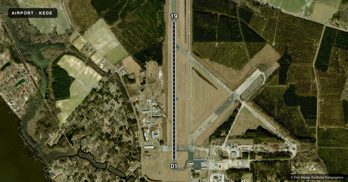
Airport sketch
Runways drawn to scale from FAA survey coordinates, rendered over satellite imagery. Not for navigation.
Approaches & charts
ILS · 1
Services on the field
Fuel grades, oxygen, maintenance, ramp storage and lighting — as declared to the FAA by the airport operator.
Fuel & services
- Fuel
- 100LLA1+
- Oxygen (bottled)
- Not available
- Oxygen (bulk)
- Not available
- Airframe repair
- Major
- Power plant repair
- Major
- Other services
- AGRI,INSTR
Ramp & ground
- Transient storage
- Tie-down
- Hangar
- Landing fee
- No fee published
- Customs
- Not available
- Lighting schedule
- SEE RMK
- Beacon schedule
- SS-SR
- Beacon
- White / Green (civil land)(WG)
- Wind indicator
- Lighted
- Segmented circle
- Yes
Fuel & FBOs
Cheapest 100LL and Jet A on the field and nearby. Always confirm with the FBO before taxi.
Airport notes
Surface conditions, obstructions, local procedures, lighting outages and other notes published with each FAA cycle.
General notes
- SEASONAL PROBLEM WITH BIRDS & DEER ON & INVOF ARPT.
- TWYS SERVING RWY 01/19 HAVE GREEN CNTRLN REFLECTORS AND NSTD SOLAR LGTS.
- FOR CD CTC WASHINGTON ARTCC AT 703-771-3587.
Lighting notes
- PAPI RWY 01 & 19 OPER CONSLY. ACTVT REIL RWY 01 & 19; MIRL RWY 01/19 - CTAF.
Fuel notes
- 100LLAFT HRS SELF SVC FUEL FOR 100LL AND A1+ AVBL WITH CREDIT CARD.
- A1+JET A TRUCK AVBL WITH SINGLE POINT AND OVER THE WING FILLING.
Runway surface & condition
- 01/19RWY 01/19 HAS 1500 FT STOPWAY AT N END & 500 FT STOPWAY AT S END.
Other notes
- 1FOR AFT HRS SVC CALL 252-217-4975.
VFR map & nearby airports
VFR sectional. Tap any ICAO chip to open that airport.
Key facts · KEDE
Answer card- ICAO
- KEDE
- Name
- NORTHEASTERN RGNL
- Location
- EDENTON, NORTH CAROLINA
- Elevation
- 18.7 ft MSL
- Traffic pattern altitude
- 1,018.7 ft MSL (1,000 AGL)
- Control tower
- Non-towered (use CTAF)
- Total runways
- 1
- Longest runway
- 01/19 · 6,001 ft
- Published ILS approaches
- 1
- Published frequencies
- 2
- Magnetic variation
- 10°
- Current flight rules
- VFR
- Current wind
- 150° at 6 kt
- Favored runway now
- RWY 19
Northeastern Rgnl sits in Edenton, North Carolina. The field elevation is 18.7 ft MSL. It has one runway, 01/19, which is 6,001 ft long and paved. There is no control tower. CTAF and UNICOM are both 123.0.
Runway 19 has the published ILS approach. Pattern altitude is not published, so use 1,000 ft AGL for light piston operations unless the current Chart Supplement says otherwise. The runway lighting is pilot controlled on CTAF. PAPI runs continuously on both ends. The remarks also note stopways at both ends of 01/19. Taxiways use green centerline reflectors and nonstandard solar lights, so expect a little extra visual scan on the ground at night.
Edenton Aviation Services is on the field. It carries 100LL and Jet A. Jet A truck service is available with single point and over the wing filling. After hours self-serve fuel is available for 100LL and Jet A plus with a credit card. Seasonal birds and deer are a real factor here. Keep a sharp lookout on taxi, takeoff and landing. For clearance delivery, contact Washington ARTCC. If you need current operating details, verify with the airport operator or the FBO directly by phone.