METAR & TAF KOCW
Current METAR
Observed 13:15Z
KOCW 271315Z AUTO 23005KT 10SM SCT044 SCT055 BKN085 26/22 A2987 RMK AO2 T02640217
- Wind
- 230° @ 5 kt
- Visibility
- 10 SM
- Temp / Dew
- 26°C / 22°C
- Altimeter
- 29.87 inHg
- Clouds
- BKN
- Density alt
- 1,429 ft
- Ceiling
- 8,500 ft AGL
- Rules
- VFR
Airport info & contacts
Manager on record, flight service, ARTCC, attendance schedule and pattern altitude — published by the FAA and refreshed every 28 days.
Location
- From city
- 0 NM NE
- VFR sectional
- CHARLOTTE
- ARTCC
- ZDC · WASHINGTON
- NOTAM facility
- OCW (NOTAM-D)
Airport manager
- Name
- JOSHUA WATERS
- Phone
- 252-946-3900
- Address
- 200 AIRPORT ROAD, WASHINGTON NC 27889-9681
Flight service · Hours
- FSS RDU
- RALEIGH1-800-WX-BRIEF
- Attendance
- MON-SAT · 0800-1700
- SUN · 1000-1700
Frequencies
Tap any row to copy the frequency to your clipboard.
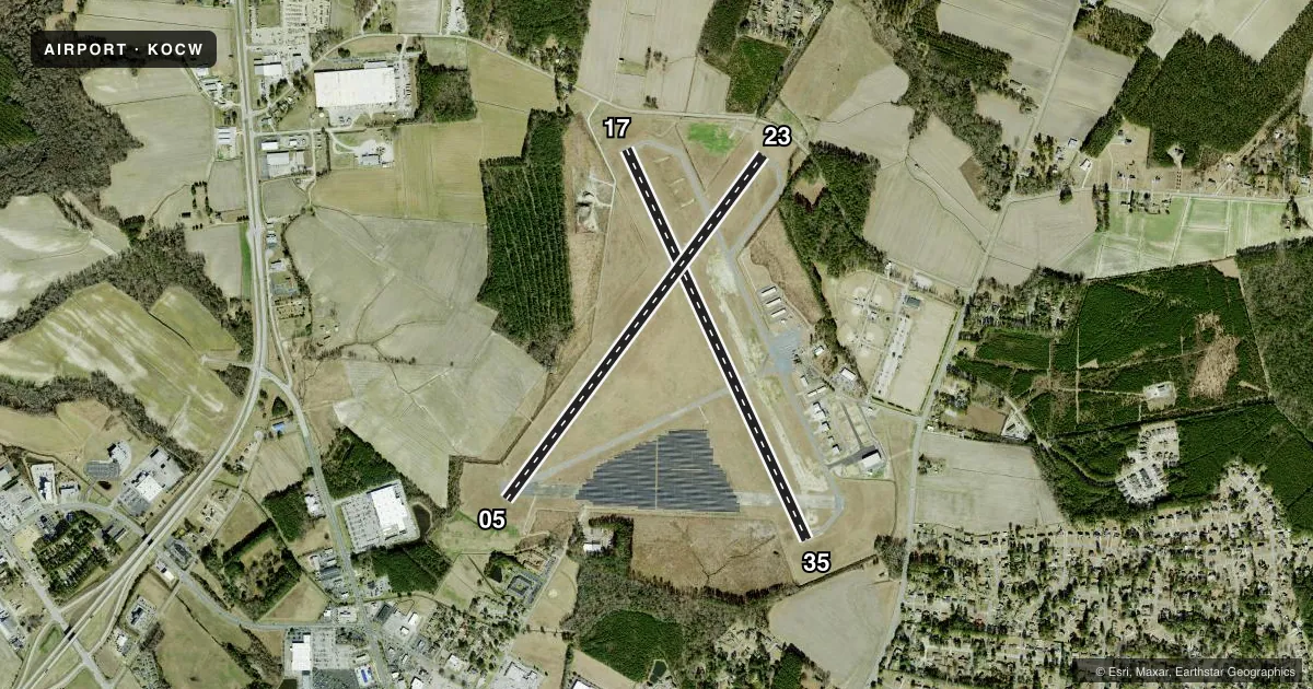
Runways & pattern
Full pagePattern entry · RWY 23
LEFT TRAFFIC| Runway | Heading (°M) | Length | Surface | Traffic |
|---|---|---|---|---|
| 17/35 | 147° / 327° | 5,001 ft | ASPH-CONC | Standard L |
| 05/23Favored | 29° / 209° | 5,000 ft | ASPH | Standard L |
Runway end performance
| End | TORA | TODA | ASDA | LDA | VGSI | Approach lights | Obstruction |
|---|---|---|---|---|---|---|---|
| 17 | — | — | — | — | — | — | 39', pole, 325' from thr, 254' R of cntrln, slope 3 |
| 35 | — | — | — | — | — | — | 16', trees, 501' from thr, 20' R of cntrln, slope 18 |
| 05 | — | — | — | — | PAPI 2-box left(3°) | — | 43', trees, 665' from thr, 253' R of cntrln, slope 10 |
| 23 | — | — | — | — | PAPI 2-box left(3.75°) | — | 17', road, 348' from thr, 0' R of cntrln, slope 8 |
Declared distances in feet. TORA = takeoff run available, TODA = takeoff distance, ASDA = accelerate-stop, LDA = landing distance.
Airport sketch
Runways drawn to scale from FAA survey coordinates, rendered over satellite imagery. Not for navigation.
Approaches & charts
ILS · 1
Services on the field
Fuel grades, oxygen, maintenance, ramp storage and lighting — as declared to the FAA by the airport operator.
Fuel & services
- Fuel
- 100LLA1+
- Oxygen (bottled)
- Not available
- Oxygen (bulk)
- Not available
- Airframe repair
- Minor
- Power plant repair
- Minor
- Other services
- AMB,INSTR,RNTL
Ramp & ground
- Transient storage
- Tie-down
- Hangar
- Landing fee
- No fee published
- Customs
- Not available
- Lighting schedule
- SEE RMK
- Beacon schedule
- SS-SR
- Beacon
- White / Green (civil land)(WG)
- Wind indicator
- Lighted
- Segmented circle
- No
Fuel & FBOs
Cheapest 100LL and Jet A on the field and nearby. Always confirm with the FBO before taxi.
Airport notes
Surface conditions, obstructions, local procedures, lighting outages and other notes published with each FAA cycle.
General notes
- TWYS NOT LGTD.
- DEER & BIRDS ON & INVOF ARPT.
- FOR CD CTC CHERRY POINT APCH AT 252-466-5960.
- RWY 17/35 UNLGTD.
- 120 FT+ TWR 3700 FT+ FM RWY 5 THLD ON CNTRLN.
Lighting notes
- MIRL RWY 05/23 PRESET ON LOW INTST; TO INCR INTST & ACTVT PAPIS RWY 05 & 23, AND REILS RWY 05 & 23 - CTAF. REILS RWY 35 OTS.
Fuel notes
- 100LLFUEL 24 HR CREDIT CARD SVC AVBL.
Approach & departure obstructions
- 17DSPLCD THLD NOT MKD AT STATED DIST OF 500 FT BUT AT 1073 FT ON RWY.
- 17APCH RATIO 18:1 TO DSPLCD THLD DUE 127 FT TREES 2597 FT FM DSPLCD THLD OFFSET 5 FT RIGHT OF CNTRLN.
- 23APCH RATIO 17:1 TO DSPLCD THLD.
Other notes
- 2FOR SVC AFTER HRS CALL 252-946-3900.
- 2UNATNDD NEW YEARS DAY, EASTER, JULY 4TH, THANKSGIVING & CHRISTMAS.
VFR map & nearby airports
VFR sectional. Tap any ICAO chip to open that airport.
Key facts · KOCW
Answer card- ICAO
- KOCW
- Name
- WASHINGTON-WARREN
- Location
- WASHINGTON, NORTH CAROLINA
- Elevation
- 37.7 ft MSL
- Traffic pattern altitude
- 1,037.7 ft MSL (1,000 AGL)
- Control tower
- Non-towered (use CTAF)
- Total runways
- 2
- Longest runway
- 17/35 · 5,001 ft
- Published ILS approaches
- 1
- Published frequencies
- 4
- Magnetic variation
- 8°
- Current flight rules
- VFR
- Current wind
- 230° at 5 kt
- Favored runway now
- RWY 23
Washington-Warren Airport sits in Washington, North Carolina. Field elevation is 37.4 ft MSL. The airport has two runways. The longest is 5,000 ft. There is no control tower. The field has one ILS approach to runway 05. Pattern altitude is not published. Use 1,000 ft AGL for light piston traffic unless the current Chart Supplement says otherwise. That puts the pattern at about 1,037 ft MSL here.
Washington-Warren Airport has one on-field FBO. Washington-Warren Airport carries 100LL and Jet A Prist. Fuel is available with 24-hour credit card service. For after-hours service, call the airport at (252) 946-3900. The airport is unattended on New Year's Day, Easter, July 4th, Thanksgiving and Christmas.
A few published remarks matter for planning. Deer and birds are on and near the airport. Taxiways are not lighted. Runway 17/35 is unlighted. Runway 05/23 has medium intensity lights preset to low. Use CTAF to raise intensity. That also activates the PAPI and runway end identifier lights on 05 and 23. There is a 120-foot or higher tower on the centerline near the runway 05 threshold. The airport also has displaced threshold and approach slope notes on both ends. Review the current Chart Supplement before arrival. This is a non-towered field with Cherry Point Approach handling clearance delivery.