METAR & TAF KPGV
Current METAR
Observed 16:35Z
KPGV 271635Z AUTO 25005KT 10SM FEW085 29/22 A2984 RMK AO2 LTG DSNT NE
- Wind
- 250° @ 5 kt
- Visibility
- 10 SM
- Temp / Dew
- 29°C / 22°C
- Altimeter
- 29.84 inHg
- Clouds
- FEW
- Density alt
- 1,812 ft
- Ceiling
- Unlimited
- Rules
- VFR
Airport info & contacts
Manager on record, flight service, ARTCC, attendance schedule and pattern altitude — published by the FAA and refreshed every 28 days.
Location
- From city
- 2 NM N
- VFR sectional
- CHARLOTTE
- ARTCC
- ZDC · WASHINGTON
- NOTAM facility
- PGV (NOTAM-D)
Airport manager
- Name
- BRANDON CRAFT
- Phone
- 252-902-2026
- Address
- 400 AIRPORT RD, GREENVILLE NC 27834
Flight service · Hours
- FSS RDU
- RALEIGH1-800-WX-BRIEF
- Attendance
- ALL
Frequencies
Tap any row to copy the frequency to your clipboard.
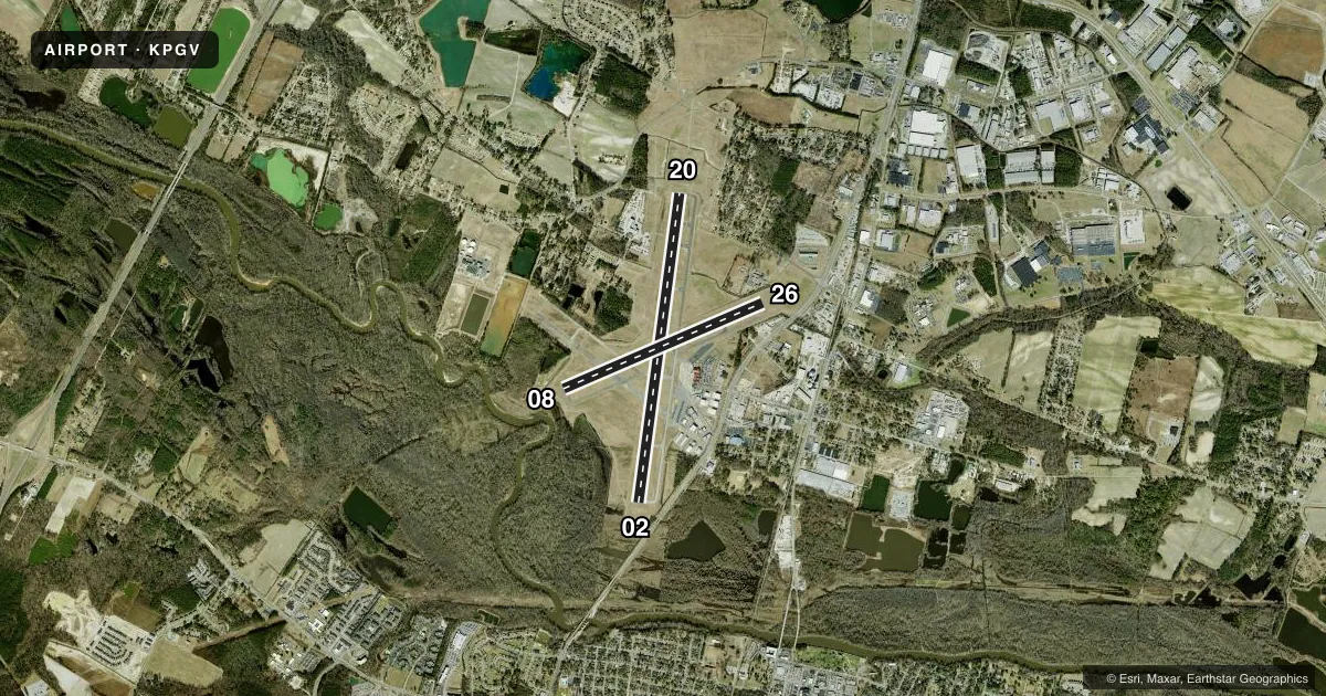
Runways & pattern
Full pagePattern entry · RWY 26
LEFT TRAFFIC| Runway | Heading (°M) | Length | Surface | Traffic |
|---|---|---|---|---|
| 02/20 | 359° / 179° | 7,175 ft | ASPH | Standard L |
| 08/26Favored | 58° / 238° | 4,997 ft | ASPH | Standard L |
Runway end performance
| End | TORA | TODA | ASDA | LDA | VGSI | Approach lights | Obstruction |
|---|---|---|---|---|---|---|---|
| 02 | 7,175' | 7,175' | 7,175' | 6,905' | PAPI 4-box left(3.1°) | — | 13', trees, 1000' from thr, 200' R of cntrln, slope 33 |
| 20 | 7,175' | 7,175' | 6,505' | 6,505' | PAPI 4-box left(3°) | MALSR | 65', trees, 2800' from thr, 800' R of cntrln, slope 40 |
| 08 | 4,997' | 4,997' | 4,997' | 4,997' | PAPI 4-box left(4°) | — | 110', trees, 1526' from thr, 200' R of cntrln, slope 12 |
| 26 | 4,997' | 4,997' | 4,997' | 4,997' | PAPI 4-box left(3°) | — | 37', pole, 1441' from thr, 77' R of cntrln, slope 33 |
Declared distances in feet. TORA = takeoff run available, TODA = takeoff distance, ASDA = accelerate-stop, LDA = landing distance.
Airport sketch
Runways drawn to scale from FAA survey coordinates, rendered over satellite imagery. Not for navigation.
Approaches & charts
ILS · 1
Services on the field
Fuel grades, oxygen, maintenance, ramp storage and lighting — as declared to the FAA by the airport operator.
Fuel & services
- Fuel
- 100LLA
- Oxygen (bottled)
- Not available
- Oxygen (bulk)
- Not available
- Airframe repair
- Major
- Power plant repair
- Major
- Other services
- AFRT,AMB,CARGO,CHTR,INSTR,RNTL
Ramp & ground
- Transient storage
- Tie-down
- Hangar
- Landing fee
- No fee published
- Customs
- Not available
- Lighting schedule
- SEE RMK
- Beacon schedule
- SS-SR
- Beacon
- White / Green (civil land)(WG)
- Wind indicator
- Lighted
- Segmented circle
- Yes
Fuel & FBOs
Cheapest 100LL and Jet A on the field and nearby. Always confirm with the FBO before taxi.
Airport notes
Surface conditions, obstructions, local procedures, lighting outages and other notes published with each FAA cycle.
General notes
- 24 HR HELICOPTER OPNS AT HOSPITAL 1.5 NM SSW OF ARPT; MONITORING CTAF.
- JET ACFT DEPARTING FROM RWY 20 SHALL HOLD ON AIR CARRIER OR GA APRON UNTIL TAKE OFF CLEARANCE IS RECEIVED.
- FOR CD IF UNA TO CTC ON FSS FREQ, CTC WASHINGTON ARTCC AT 703-771-3587.
Lighting notes
- ACTVT MALSR RWY 20; PAPI RWYS 02, 20, 08 & 26; HIRL RWY 02/20; MIRL RWY 08/26 - CTAF.
Runway surface & condition
- 02/20PCR VALUE: 326/F/B/X/T
- 08/26PCR VALUE: 153/F/B/X/T
- 08/26RWY 08/26 NOT AVBL FOR PART 121/PART 380 OPS WITH SKED PAX CARRYING OPS MORE THAN 9 PAX SEATS AND NON-SKED PAX CARRYING OPS MORE THAN 30 PAX SEATS.
Approach & departure obstructions
- 08RUNWAY 8-26 MARKINGS LACK VISIBILITY
- 26RUNWAY 8-26 MARKINGS LACK VISIBILITY
Other notes
- ARPT CLSD TO UNSKED ACR OPS EXCP 8 HRS PPR 252-902-2026 DAILY 0200-1000. INDEX C ARFF EQUIP AVBL UPON REQ.
- 08/26RUNWAY 8-26 NOT AVAILABLE FOR AIR CARRIER USE; UNEVEN SURFACE.
VFR map & nearby airports
VFR sectional. Tap any ICAO chip to open that airport.
Key facts · KPGV
Answer card- ICAO
- KPGV
- Name
- PITT-GREENVILLE
- Location
- GREENVILLE, NORTH CAROLINA
- Elevation
- 26.4 ft MSL
- Traffic pattern altitude
- 1,026.4 ft MSL (1,000 AGL)
- Control tower
- Non-towered (use CTAF)
- Total runways
- 2
- Longest runway
- 02/20 · 7,175 ft
- Published ILS approaches
- 1
- Published frequencies
- 2
- Magnetic variation
- 9°
- Current flight rules
- VFR
- Current wind
- 250° at 5 kt
- Favored runway now
- RWY 26
Pitt-Greenville Airport sits in Greenville, North Carolina. Field elevation is 26.4 ft MSL. The airport has two asphalt runways. The longest is 02/20 at 7,175 ft. Runway 08/26 is 4,997 ft. There is no control tower. Pilots use CTAF 122.8 for self-announce traffic. Pattern altitude is not published. Use the standard 1,000 ft AGL for light piston traffic unless the current FAA Chart Supplement says otherwise.
One ILS is published for runway 20. The field also has PAPI on runways 02, 20, 08 and 26. The lighting setup on 20 includes medium intensity approach lights with runway alignment indicator lights. High intensity runway lights are installed on 02/20. Medium intensity runway lights are installed on 08/26. The on-field FBO is Pitt-Greenville Airport. It carries AVGAS 100LL and Jet A. Call ahead at (252) 902-2026.
A few remarks matter for planning. Runway 08/26 is not available for air carrier use because of an uneven surface. Its markings also lack visibility. The airport is closed to unscheduled aircraft operations unless you get permission eight hours ahead by calling the airport number during the published window. Jet departures from runway 20 are supposed to hold on the apron until takeoff clearance is received. The hospital helicopter traffic 1.5 NM south-southwest is another reason to stay sharp on CTAF.