METAR & TAF 7NC
7NC does not publish a METAR.
Showing the nearest reporting station: KEDE (NORTHEASTERN RGNL) · 18.5 NM away. Conditions at 7NC may differ.
METAR · KEDE
Observed 15:15Z
KEDE 271515Z AUTO 20004KT 10SM BKN090 28/24 A2988 RMK AO2 T02810235
- Wind
- 200° @ 4 kt
- Visibility
- 10 SM
- Temp / Dew
- 28°C / 24°C
- Altimeter
- 29.88 inHg
- Clouds
- BKN
- Density alt
- 1,632 ft
- Ceiling
- 9,000 ft AGL
- Rules
- VFR
Airport info & contacts
Manager on record, flight service, ARTCC, attendance schedule and pattern altitude — published by the FAA and refreshed every 28 days.
Location
- From city
- 8 NM SE
- VFR sectional
- CHARLOTTE
- ARTCC
- ZDC · WASHINGTON
- NOTAM facility
- RDU (NOTAM-D)
Airport manager
- Name
- DONALD L. STOTESBERRY
- Phone
- 252-809-9010
- Address
- 5212 NC HWY 99 SOUTH, PANTEGO NC 27860-8916
Flight service · Hours
- FSS RDU
- RALEIGH1-800-WX-BRIEF
- Attendance
- MON-SAT · 0800-1700
- SUN · 1300-1700
Frequencies
Tap any row to copy the frequency to your clipboard.
Runways & pattern
Full pagePattern entry · RWY 23
LEFT TRAFFICRunway end performance
| End | TORA | TODA | ASDA | LDA | VGSI | Approach lights | Obstruction |
|---|---|---|---|---|---|---|---|
| 05 | — | — | — | — | — | — | 13', brush, 21' from thr, 81' R of cntrln, slope 1 |
| 23 | — | — | — | — | — | — | 32', pole, 57' from thr, 67' R of cntrln, slope 1 |
Declared distances in feet. TORA = takeoff run available, TODA = takeoff distance, ASDA = accelerate-stop, LDA = landing distance.
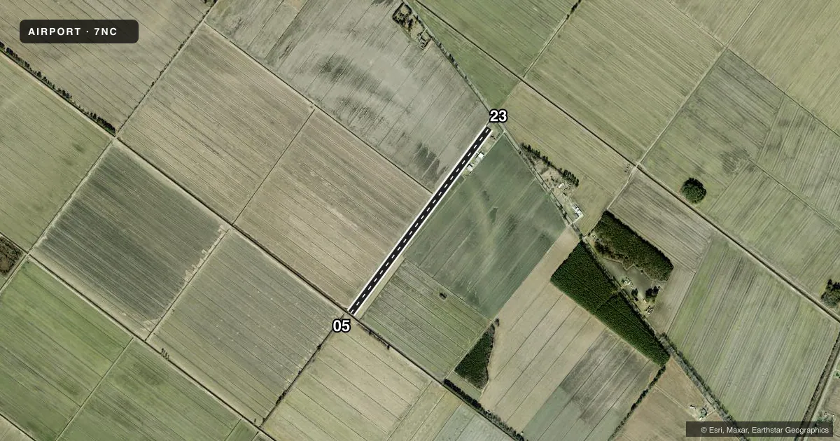
Airport sketch
Runways drawn to scale from FAA survey coordinates, rendered over satellite imagery. Not for navigation.
Approaches & charts
Services on the field
Fuel grades, oxygen, maintenance, ramp storage and lighting — as declared to the FAA by the airport operator.
Fuel & services
- Fuel
- Not available
- Airframe repair
- Major
- Power plant repair
- Minor
- Other services
- AGRI,INSTR,SALES,SURV
Ramp & ground
- Transient storage
- Tie-down
- Landing fee
- No fee published
- Lighting schedule
- SEE RMK
- Wind indicator
- Yes
- Segmented circle
- No
Fuel & FBOs
Cheapest 100LL and Jet A on the field and nearby. Always confirm with the FBO before taxi.
Airport notes
Surface conditions, obstructions, local procedures, lighting outages and other notes published with each FAA cycle.
General notes
- HEAVY AGRICULTURAL ACFT OPS MAR-NOV.
- RWY 23 HAS UNMKD PLINE 60 FT +/- EACH SIDE OF THLD; POWER POLES EACH SIDE OF THLD WITH PLINE BURIED ACRS RWY WIDTH AT THLD. ADDNL UNMKD 50 FT PLINE 1200 FT FROM RWY 23 THLD.
- PARL TURF RWY ARPT WI 3/4 MILE NW.
- FOR CD CTC WASHINGTON ARTCC AT 703-771-3587.
- RWY 05 HAS 8 FT DITCH 12 FT FROM THLD BOTH SIDES CNTRLN.
- MNT FREQ 122.8 FOR TFC ADZY.
Lighting notes
- TO ACTVT LIRL RWY 05/23 CALL 252-809-9010.
Runway surface & condition
- 05/23NSTD LIRL DUE TO SPACING OF RWY LGTS AND NO END LGTS.
Approach & departure obstructions
- 05RWY 05 & 23 MKD WITH YELLOW CONES.
- 23DUE TO BURIED PLINE, NO MKD DTHR.
Other notes
- VFR ONLY.
VFR map & nearby airports
VFR sectional. Tap any ICAO chip to open that airport.
Key facts · 7NC
Answer card- ICAO
- 7NC
- Name
- DONALD'S AIR PARK INC
- Location
- PLYMOUTH, NORTH CAROLINA
- Elevation
- 18 ft MSL
- Traffic pattern altitude
- 1,018 ft MSL (1,000 AGL)
- Control tower
- Non-towered (use CTAF)
- Total runways
- 1
- Longest runway
- 05/23 · 4,195 ft
- Published ILS approaches
- 0
- Published frequencies
- 1
- Magnetic variation
- 9°
- Current flight rules
- VFR
- Current wind
- 200° at 4 kt
- Favored runway now
- RWY 23
Donald's Air Park Inc sits in Plymouth, North Carolina. Field elevation is 18 ft MSL. The airport has one runway. Runway 05/23 is 4,195 ft of turf, so it is the runway to plan around here. There is no control tower. CTAF is 122.9. The published notes also say to maintain 122.8 for traffic advisory, so verify the current Chart Supplement and use the published radio guidance before arrival.
No ILS approaches are published. Pattern altitude is not published. Use the standard 1,000 ft AGL pattern for light piston aircraft unless the current Chart Supplement says otherwise. The field is VFR only. That matters here because runway 23 has unmarked power lines near the threshold. There is also an additional unmarked 50-foot power line about 1,200 ft from the runway 23 threshold. Runway 05 has an 8-foot ditch 12 feet from the threshold on both sides of the centerline. Runway 05/23 is marked with yellow cones. Low intensity runway lights are installed, but they are nonstandard and there are no end lights. To turn the lights on, call the number in the current Chart Supplement. Heavy agricultural aircraft operations occur from March through November. There is also a parallel turf runway airport within three quarters of a mile northwest, so keep your eyes up in the pattern.