METAR & TAF 7W6
Current METAR
Observed 13:15Z
K7W6 271315Z AUTO 16003KT 10SM CLR 26/21 A2988 RMK AO2 T02560212
- Wind
- 160° @ 3 kt
- Visibility
- 10 SM
- Temp / Dew
- 26°C / 21°C
- Altimeter
- 29.88 inHg
- Clouds
- CLR
- Density alt
- 1,378 ft
- Ceiling
- Unlimited
- Rules
- VFR
Airport info & contacts
Manager on record, flight service, ARTCC, attendance schedule and pattern altitude — published by the FAA and refreshed every 28 days.
Location
- From city
- 7 NM N
- VFR sectional
- CHARLOTTE
- ARTCC
- ZDC · WASHINGTON
- NOTAM facility
- RDU (NOTAM-D)
Airport manager
- Name
- JOHNNY GIBBS
- Phone
- 252-473-3444
- Address
- PO BOX 189, SWAN QUARTER NC 27885
Flight service · Hours
- FSS RDU
- RALEIGH1-800-WX-BRIEF
- Attendance
- Unattended
Frequencies
Tap any row to copy the frequency to your clipboard.
Runways & pattern
Full pagePattern entry · RWY 11
RIGHT TRAFFICRunway end performance
| End | TORA | TODA | ASDA | LDA | VGSI | Approach lights | Obstruction |
|---|---|---|---|---|---|---|---|
| 11 | — | — | — | — | PAPI 2-box left(3°) | — | — |
| 29 | — | — | — | — | PAPI 2-box left(3°) | — | 37', trees, 1415' from thr, 27' R of cntrln, slope 32 |
Declared distances in feet. TORA = takeoff run available, TODA = takeoff distance, ASDA = accelerate-stop, LDA = landing distance.
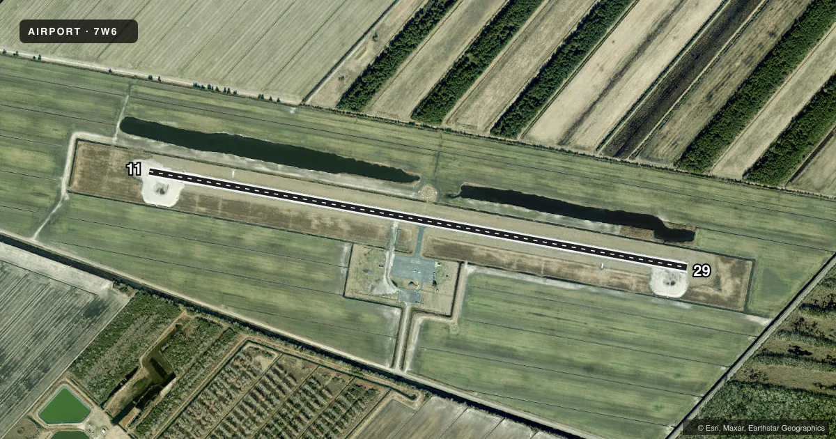
Airport sketch
Runways drawn to scale from FAA survey coordinates, rendered over satellite imagery. Not for navigation.
Approaches & charts
Services on the field
Fuel grades, oxygen, maintenance, ramp storage and lighting — as declared to the FAA by the airport operator.
Fuel & services
- Fuel
- 100LL
- Oxygen (bottled)
- Not available
- Oxygen (bulk)
- Not available
- Airframe repair
- Not available
- Power plant repair
- Not available
Ramp & ground
- Transient storage
- Tie-down
- Landing fee
- No fee published
- Lighting schedule
- SEE RMK
- Beacon schedule
- SS-SR
- Beacon
- White / Green (civil land)(WG)
- Wind indicator
- Lighted
- Segmented circle
- Yes
Fuel & FBOs
Cheapest 100LL and Jet A on the field and nearby. Always confirm with the FBO before taxi.
Airport notes
Surface conditions, obstructions, local procedures, lighting outages and other notes published with each FAA cycle.
General notes
- R5314 5 MI NORTH OF ARPT AND R5313 5 MI EAST HAVE HVY CONCENTRATIONS OF MIL ACFT WI 1000 FT AGL AND IN EXCESS OF 500 KTS. MNVRNG FOR LDG AND AFT TKOF SHOULD RMN OVER LAND EAST OF ARPT.
- DEER & BIRDS ON & INVOF ARPT.
- GEESE NESTING NORTH SIDE OF RWY AT UPPER AND MIDDLE PONDS.
- FOR CD CTC WASHINGTON ARTCC AT 703-771-3587.
Lighting notes
- ACTVT PAPI RWY 11 & 29; MIRL RWY 11/29 - CTAF.
Fuel notes
- 100LL24 HR SELF SERVE WITH CREDIT CARD.
Other notes
- 1FOR ASSISTANCE CTC HYDE COUNTY DISPATCH 252-473-3444.
VFR map & nearby airports
VFR sectional. Tap any ICAO chip to open that airport.
Key facts · 7W6
Answer card- ICAO
- 7W6
- Name
- HYDE COUNTY
- Location
- ENGELHARD, NORTH CAROLINA
- Elevation
- 6.7 ft MSL
- Traffic pattern altitude
- 1,006.7 ft MSL (1,000 AGL)
- Control tower
- Non-towered (use CTAF)
- Total runways
- 1
- Longest runway
- 11/29 · 5,002 ft
- Published ILS approaches
- 0
- Published frequencies
- 4
- Magnetic variation
- 9°
- Current flight rules
- VFR
- Current wind
- 160° at 3 kt
- Favored runway now
- RWY 11
Hyde County Airport (7W6) sits in Engelhard, North Carolina. Field elevation is 6.7 ft MSL. The airport has one runway. Runway 11/29 is 5,002 ft asphalt. There is no control tower. Pattern altitude is not published, so use the standard 1,000 ft AGL for light piston operations unless the current Chart Supplement says otherwise.
No ILS approaches are published here. CTAF and UNICOM are both 122.7. Cherry Point Approach and Departure are on 119.75 and 360.775. Published remarks matter here. PAPI is available on both runway ends. Medium intensity runway lights are controlled on CTAF. 24-hour self-serve 100LL is available with credit card. There are no on-field FBOs listed. Call the airport operator or the field directly before you go if you need ramp or service details.
This is a low-elevation coastal field, so watch the weather and the traffic picture closely. The published remarks also call out military activity near restricted areas north and east of the airport. Keep maneuvering for landing and after takeoff over land east of the airport. Deer, birds and nesting geese are also noted on and near the field. For clearance delivery, contact Washington ARTCC at 703-771-3587.