METAR & TAF KHSE
Current METAR
Observed 15:51Z
KHSE 271551Z AUTO 12006KT 10SM CLR 28/20 A2990 RMK AO2 SLP123 T02780200 $
- Wind
- 120° @ 6 kt
- Visibility
- 10 SM
- Temp / Dew
- 28°C / 20°C
- Altimeter
- 29.90 inHg
- Clouds
- CLR
- Density alt
- 1,605 ft
- Ceiling
- Unlimited
- Rules
- VFR
Airport info & contacts
Manager on record, flight service, ARTCC, attendance schedule and pattern altitude — published by the FAA and refreshed every 28 days.
Location
- From city
- 4 NM E
- VFR sectional
- CHARLOTTE
- ARTCC
- ZDC · WASHINGTON
- NOTAM facility
- HSE (NOTAM-D)
Airport manager
- Name
- MARK SEAMAN
- Phone
- 252-475-9000
- Address
- 1401 NATIONAL PARK DRIVE, MANTEO NC 27954
Flight service · Hours
- FSS RDU
- RALEIGH1-800-WX-BRIEF
- Attendance
- Unattended
Frequencies
Tap any row to copy the frequency to your clipboard.
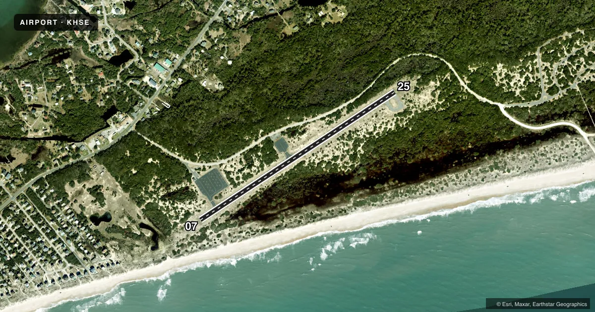
Runways & pattern
Full pagePattern entry · RWY 07
LEFT TRAFFICRunway end performance
| End | TORA | TODA | ASDA | LDA | VGSI | Approach lights | Obstruction |
|---|---|---|---|---|---|---|---|
| 07 | — | — | — | — | — | — | 15', brush, 413' from thr, 232' R of cntrln, slope 14 |
| 25 | — | — | — | — | — | — | 24', tree, 282' from thr, 121' R of cntrln, slope 3 |
Declared distances in feet. TORA = takeoff run available, TODA = takeoff distance, ASDA = accelerate-stop, LDA = landing distance.
Airport sketch
Runways drawn to scale from FAA survey coordinates, rendered over satellite imagery. Not for navigation.
Approaches & charts
Services on the field
Fuel grades, oxygen, maintenance, ramp storage and lighting — as declared to the FAA by the airport operator.
Fuel & services
- Fuel
- Not available
- Oxygen (bottled)
- Not available
- Oxygen (bulk)
- Not available
- Airframe repair
- Not available
- Power plant repair
- Not available
Ramp & ground
- Transient storage
- Tie-down
- Landing fee
- No fee published
- Customs
- Not available
- Wind indicator
- Lighted
- Segmented circle
- No
Fuel & FBOs
Cheapest 100LL and Jet A on the field and nearby. Always confirm with the FBO before taxi.
Airport notes
Surface conditions, obstructions, local procedures, lighting outages and other notes published with each FAA cycle.
General notes
- +10-35 FT SAND DUNES AND SCRUB TREES BOTH SIDES OF RWY WITHIN ROFA.
- ARPT CLSD 30 MIN AFTER SS TIL 30 MIN BEFORE SR. ALL NIGHTTIME OPNS PROHIBITED.
- HIGH SPEED LOW LEVEL MIL OPNS IN VIC OF ARPT.
- FLOCKS OF SEAGULLS ON & INVOF OF ARPT.
- RWY 07/25 SAFETY AREA IS LOOSE SAND & DUNES - NOT SUITABLE FOR ACFT.
- ADDITIONAL ACFT PARKING AVBL ON MID-FIELD APRON.
- ARPT LCTD IN CAPE HATTERAS NTL SEASHORE. MNTN 2000 FT VER & HORIZONTAL DIST FM SEASHORE BEACHES.
- FOR CD CTC CHERRY POINT APCH AT 252-466-5960.
Approach & departure obstructions
- 075 FT SAND DUNES 0-200 FT FM THR 122 FT R OF CNTRLN, AND 10 FT SAND DUNES 0-200 FT FM THR 138 FT L OF CNTRLN.
- 258 FT DUNE 52 FT FM THR 126 FT L OF CNTRLN; 15 FT WINDSOCK 72 FT FM THR 221 FT L OF CNTRLN; AND 26 FT TREES 0-100 FT FM THR 152 FT R OF CNTRLN.
Other notes
- OWNERNCDOT DIVISION OF AVIATION COOPERATING AGENCY UNDER MOU; CTC NR 919-814-0550.
- MANAGERNTL PARKS SVC NR ANSWERED 7 DAYS A WEEK BTWN 0800 TO 1700.
VFR map & nearby airports
VFR sectional. Tap any ICAO chip to open that airport.
Key facts · KHSE
Answer card- ICAO
- KHSE
- Name
- BILLY MITCHELL
- Location
- HATTERAS, NORTH CAROLINA
- Elevation
- 16.3 ft MSL
- Traffic pattern altitude
- 1,016.3 ft MSL (1,000 AGL)
- Control tower
- Non-towered (use CTAF)
- Total runways
- 1
- Longest runway
- 07/25 · 3,002 ft
- Published ILS approaches
- 0
- Published frequencies
- 3
- Magnetic variation
- 10°
- Current flight rules
- VFR
- Current wind
- 120° at 6 kt
- Favored runway now
- RWY 07
Billy Mitchell (KHSE) sits in Hatteras, North Carolina. Field elevation is 16.3 ft MSL. The airport has one runway. Runway 07/25 is 3,002 ft long with asphalt pavement. There is no control tower. Pattern altitude is not published, so use 1,000 ft AGL for light piston traffic unless the current Chart Supplement says otherwise.
No ILS approaches are published here. Clearance delivery is handled through Cherry Point Approach at 252-466-5960. The airport is in Cape Hatteras National Seashore. Keep 2,000 ft vertical and horizontal distance from seashore beaches. That matters here because the field sits low and exposed near the coast. Expect sand dunes, scrub trees and bird activity around the runway environment. Published remarks also note high speed low level military operations in the area.
There are no on-field FBOs listed. Check with the airport operator or the FBO directly by phone for current fuel and service availability before you go. The airport is closed 30 minutes after sunset until 30 minutes before sunrise. All nighttime operations are prohibited. Additional aircraft parking is available on the mid-field apron. Runway 07 and 25 both have nearby dune and obstacle notes, so a careful look at the current Chart Supplement is smart before arrival.